4:30 PM UPDATE: More Heat & Storms for Saturday
4:30 PM UPDATE: Well we did it! We hit 90° again in Milwaukee! The first time we've hit back-to-back 90s in years, but we will fall short of the record of 95° set in 1933.
Storms have still stayed out of our area, but a few storms are beginning to pop in Illinois and northern Iowa. Model trend continues to show these storms staying away from Wisconsin, but we will keep the chance in until around 7:00 PM - it doesn't look likely.
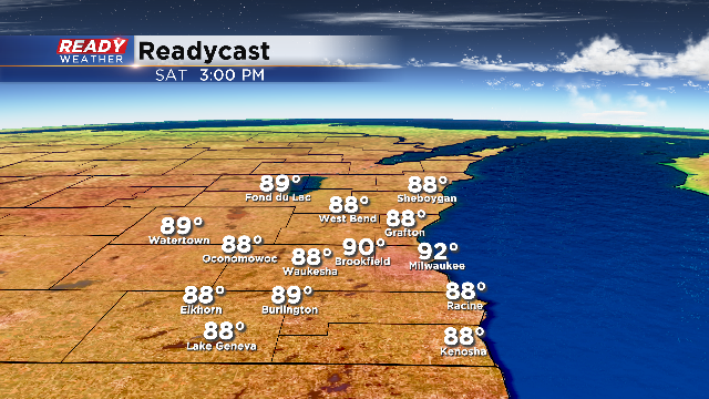
Noon UPDATE: The heat and humidity is in full force with most spots in the 80s as of noon with high humidity as well. Temperatures will continue warming the next few hours with high temperatures for most in the lower 90s. The record is 95 in Milwaukee.
We are still tracking the threat for showers and storms this afternoon and evening with the isolated threat of a stronger storm. The latest runs of the majority of weather models keep SE Wisconsin out of the threat for severe weather today, but there are still a few models who have showers and storms forming over the area over the next few hours. The best time for strong to severe storms will be from now until around 7 PM.
If strong storms do form, they will likely go severe very quickly. That means that the storm could go from just a tiny shower on radar to a full blown damaging wind and hail maker in less than 30 minutes. Because of this, it is a good idea to make sure you have a way to get warnings all day long and download the CBS 58 weather app and keep your phone volume on so you can get any alerts.
ORIGINAL: Southwest to west winds on Saturday will push temperatures back into the lower 90s across southeastern Wisconsin! The record high for Saturday is 95 degrees, so we will approach the record along with some very thick humidity. We average 2 days of 90 degree heat for the entire month of June!

Along with the heat and humidity will be the prospect of storms! The storms from Friday night have left an outflow boundary across southeastern Wisconsin. This boundary serves as a focus for additional showers and storms when peak heating is achieved.

The 4KM NAM shows a blowup of storms for Saturday afternoon and evening along and south of I-94. If storms can go they will quickly go severe and produce damaging winds, large hail, and even an isolated tornado.
If the outflow boundary sets up south we might not see much, so we will need to monitor it closely throughout your Saturday. The best timing for storms is from 2 pm till 7 pm as they move south.
Sunday will be completely different with a high near 70 and low humidity!