8 PM Severe Weather Update


8 pm Update...

Over the last hour there has been an increase in scattered showers and some rumbles of thunder across southern Wisconsin. We will continue to see scattered showers and a few storms through midnight. No watches or warnings are expected.

Our attention quickly shifts to falling temperatures on Wednesday. A mix of rain and sleet will begin the morning and quickly transition to all snow between 8 am and 10 am. Many areas will pick up 2" to 4" of snow by Wednesday evening!
6 pm Update...
Thankfully the strongest of the storms have remained just to the south of our area. Central and northern Illinois have been pounded with severe weather this afternoon. Numerous reports of tornadoes have occurred, including damage around the city of Ottawa, IL.

Scattered showers and storms remain possible this evening; however, the overall severe threat looks to stay to our south.
4 pm Update...
A new tornado watch has been issued for all of northern Illinois. We will need to watch those cells very carefully. If those storms pull across southern Wisconsin they will have a chance to rotate and possible produce a quick tornado. I do want to stress that there is no watch or warning for southeastern Wisconsin at this time!
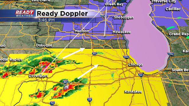
We are expecting scattered showers and storms to move in between 5 pm and 10 pm. Storms that do arrive could produce quarter hail, strong winds, and very heavy rainfall! Snow arrives for tomorrow! Please scroll down to find out the latest snowfall forecast.
We've tracked one round of severe thunderstorms this morning with heavy rain and hail. Take a look at these hail stones from the Cedar Grove area.

Now, conditions are relatively quiet. While an isolated isolated storm can't be ruled out this afternoon, we are anticipating storms to re-fire this evening. The latest info has storms rolling over the IL/WI border around 6pm and pushing into the metro area during the 8 o' clock hour. Once again, heavy rain and hail are likely. Isolated rotation is something we will be watching closely as well.
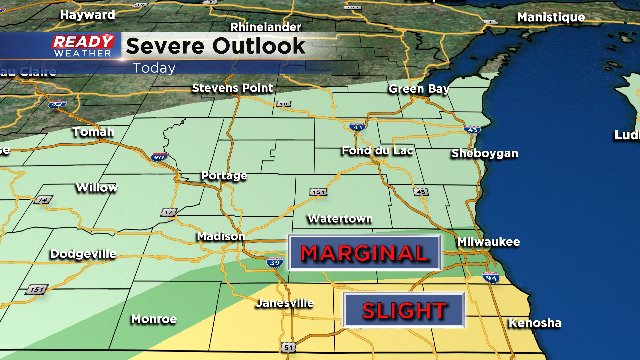
The National Weather Service's "Storm Prediction Center" has central parts of the viewing area under a marginal risk for severe storms this evening and a "slight" or slightly greater chance for severe storms, just south of the marginal risk.
Stay tuned to the latest forecasts over the next 24 hours as much will change. While storms are in the forecast tonight, the switch from rain to snow tomorrow morning could be equally as hazardous.
The National Weather Service has also issued a "Winter Weather Advisory" for all but our southern counties as shown below. This kicks off at 6AM tomorrow morning and runs until 6PM.

Snowfall amounts will be in the range of 2-5" with highest amounts expected across our northern locations.
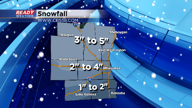
Rain transitions to snow from west to east through 6AM-9AM. This transition will likely make the commute tricky, especially if you have a later commute in the Milwaukee area as the transitions occurs lakeside mid morning. Snow showers will be likely the rest of the day and by the evening these are the totals you can expect in your area.
Stay tuned to the Ready Weather Team for additional updates through the day and overnight.
If you have hail or other storm pictures, please send them to [email protected] or download our free CBS58 weather app and send it this way.
We'll start to see a changeover to snow around the morning commute on Wednesday at least for the metro area. The snow will come earlier north and west of Milwaukee and Waukesha. It should be snow for everyone by mid morning, say 9 or 10am. The snow won't stop until 8pm. So this is almost a 12-hour event at least for the immediate area. 1-3" of snow can be expected along and south of I-94. From I-94 and points north, 3-5 inches of snowfall is possible as the snow continues most of Wednesday.


There are a few more chances of snow Thursday and Friday night. Accumulations should be minor. Regardless, this is a perfect time to download the free CBS58 weather app when you're on the go.