Another Cool Stretch Ahead
The work week started off with a bang across eastern Wisconsin with hail producing scattered storms. We had reports of hail as large as 1.75" and golf ball size hail has reportedly smashed one viewer's windshield as storms went under warning late yesterday afternoon in Washington and Ozaukee counties.

Monday also tied with the 18th of the month as our warmest day of the year in Milwaukee, as we topped out at 78°. Now the storms are gone and so is the warmth. Take a look at the temperature change from noon today to noon time yesterday.

I looked thrilled about this, don't I?! And if you're a lakeside dweller, this next stretch of weather might be especially hard to take. As water temperatures hover around forty degrees any days with a lake breeze are still pretty much a doozy. And unfortunately, the weather pattern over the next ten days will feature many days with an onshore wind, at least now through next Monday. That means we'll be looking at highs in the 40s and lower 50s into next week. Additionally, four days will include a chance for rain, with the first at bat coming by tomorrow evening. Rain will be scattered about through Thursday before we clear out Friday. As we head into the weekend, more chances return starting late Saturday and lingering through Sunday night. A persistent lake breeze will keep us ten to fifteen degrees below the normal high of 58° through this weekend.
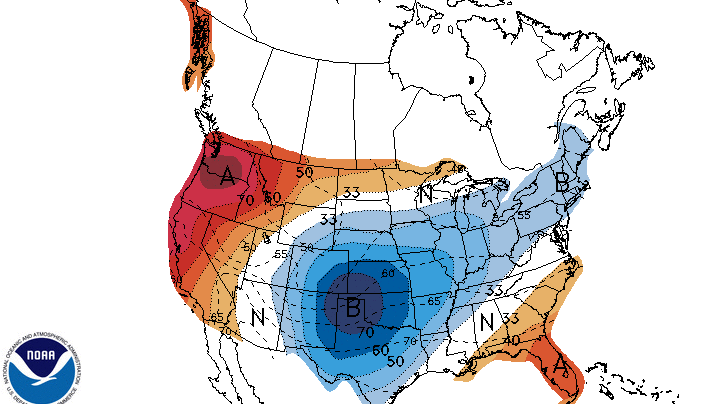
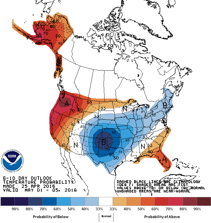
The National Weather Service's "Climate Prediction Center" also mirrors our thoughts on a continued cool stretch into the first few days of May.
As we head into next week we start to dry out, but temps remain on the cool side. We start to turn the corner with some more sun back in the forecast and by the end of the week and into that following weekend, some model data has us warming up nicely. Fingers crossed! Until then... mother nature is still trying to load in spring across southeast Wisconsin.
I'm meteorologist Rebecca Schuld