Major Storm To Impact Wisconsin Tuesday
A storm brewing in the Pacific is now onshore across the West Coast. As we are now able to sample the storm, our confidence is increasing in terms of the track and intensity of this storm as well as precipitation types and amounts expected here across our area. At this time Fond du Lac and Dodge County are under a Winter Storm Watch for the potential of snowfall over six inches along with gusty winds which will make travel difficult and at times dangerous. The watch begins 6AM Tuesday and runs until 6AM Wednesday. Take a look at the areas across the state and region under the watch and in the green, a blizzard watch.

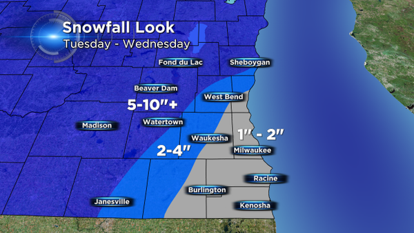
Snowfall amounts in the blue shaded counties will likely be in the range of 5 to 10 inches with localized spots possibly seeing a bit more. For the rest of our area, we may still need to shovel, but snow amounts will be much less and more rain is expected in places like Milwaukee, Waukesha, Racine and Kenosha. Here's the latest snowfall forecast from the CBS58 weather team.
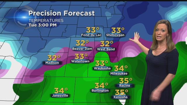
As you can see, you may not need to shovel much at all in the metro. However, during the first part of Tuesday snowfall is still likely across the entire area. As the day unfolds, temps will warm to the middle 30s and snow will mix with sleet and then transition to rain by the middle of the afternoon. Additionally, winds will ramp up from the east at 12 to 25 mph. This will lead to reduced visibilities and as the storm winds down, blowing snow may still be an issue into early Wednesday.
There is still some time for adjustments to this forecast so please continue to stay with CBS58 for the latest updates on this storm.
I'm meteorologist Rebecca Schuld