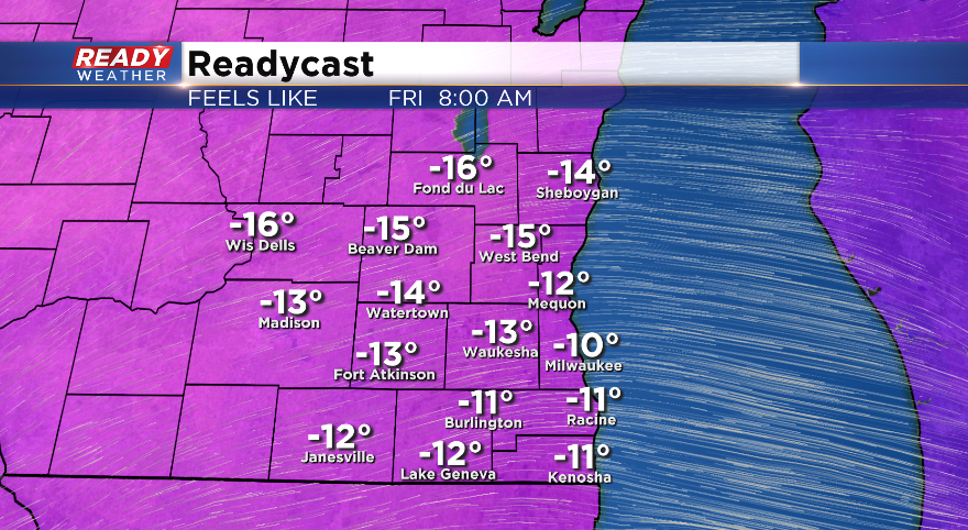
9 AM Update: Light snow ending; wind chills below-zero


Updated: 8:42 a.m. February 13, 2020
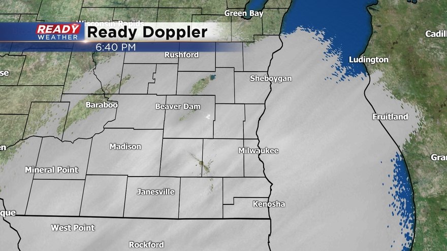
This will be the final update for the snow even February 12th into February 13th.
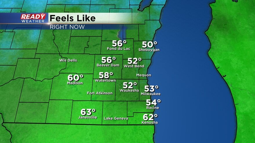
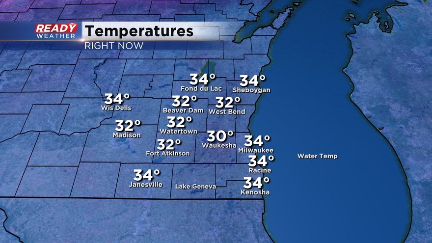
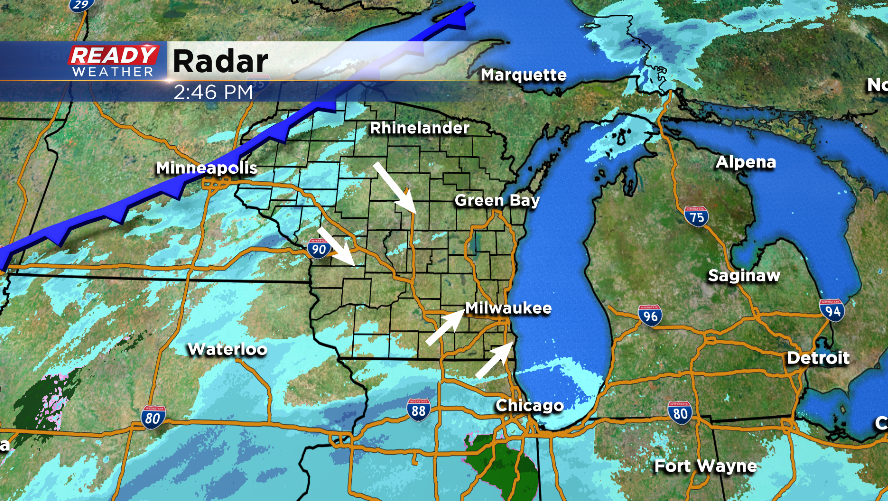
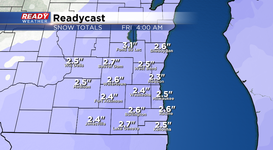
Just a little bit of lingering snow left in areas like Milwaukee, Waukesha and spots south of there. Little to no additional accumulation is expected. Snow reports are still coming in with most spots in the 2-4" range.

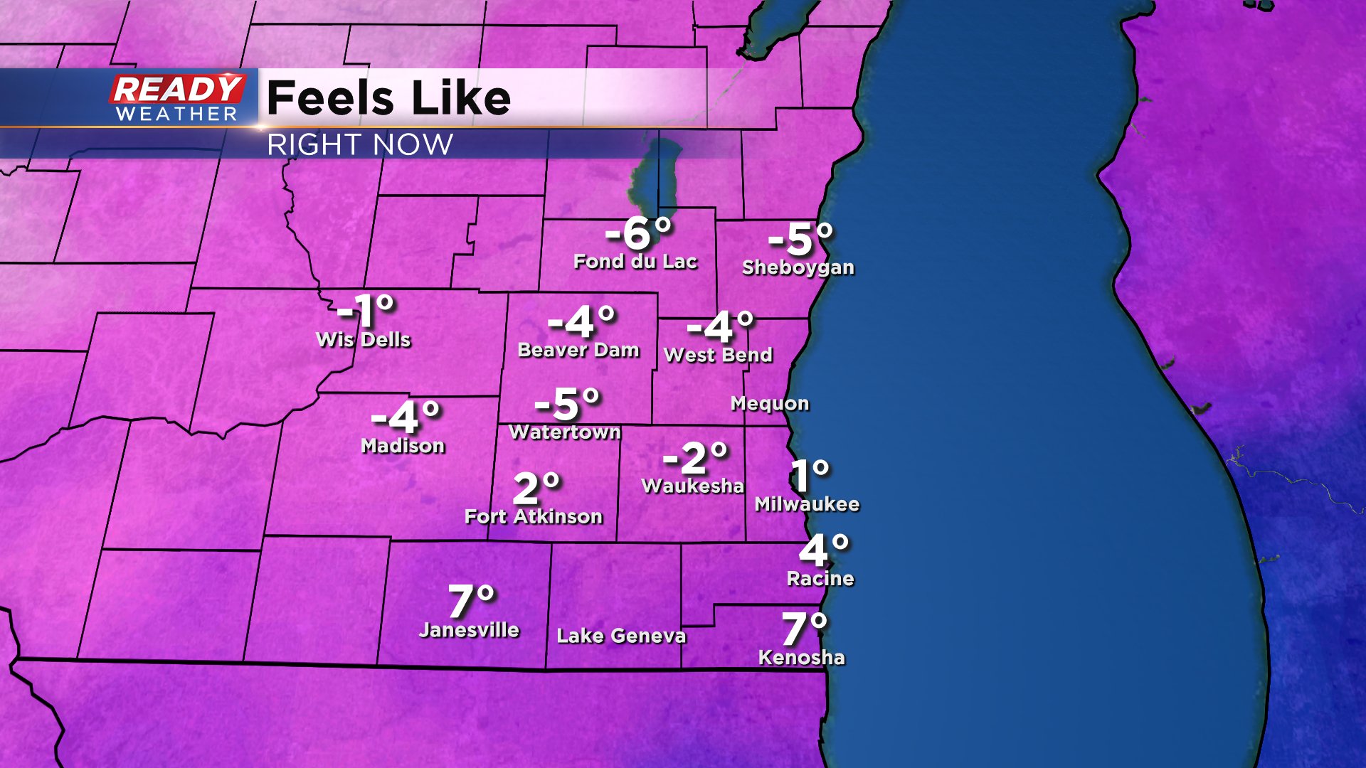
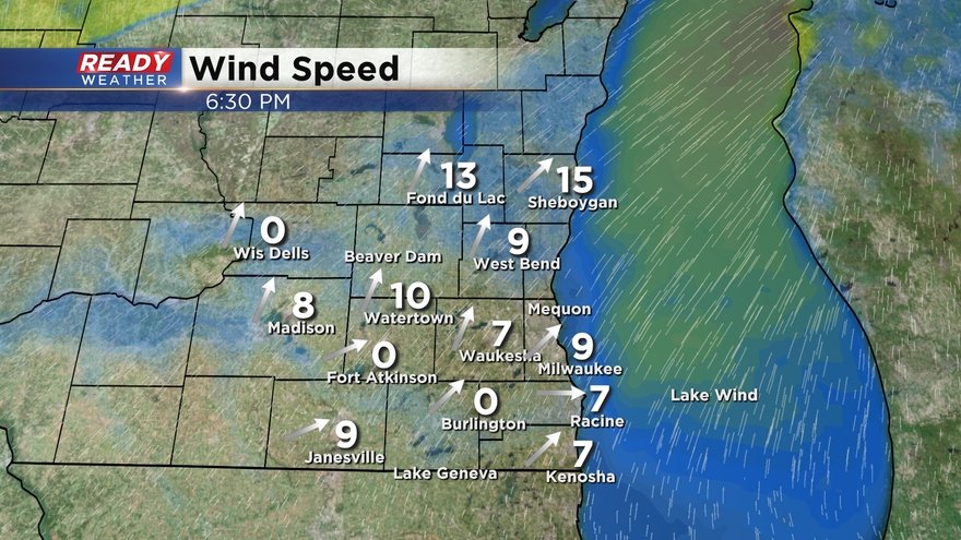
As the snow wraps up the focus shifts. Current wind chills are in the single digits and teens below-zero and are expected to stay there most of the day with wind gusting to 25 mph.
------
Updated: 4:52 a.m. February 13, 2020
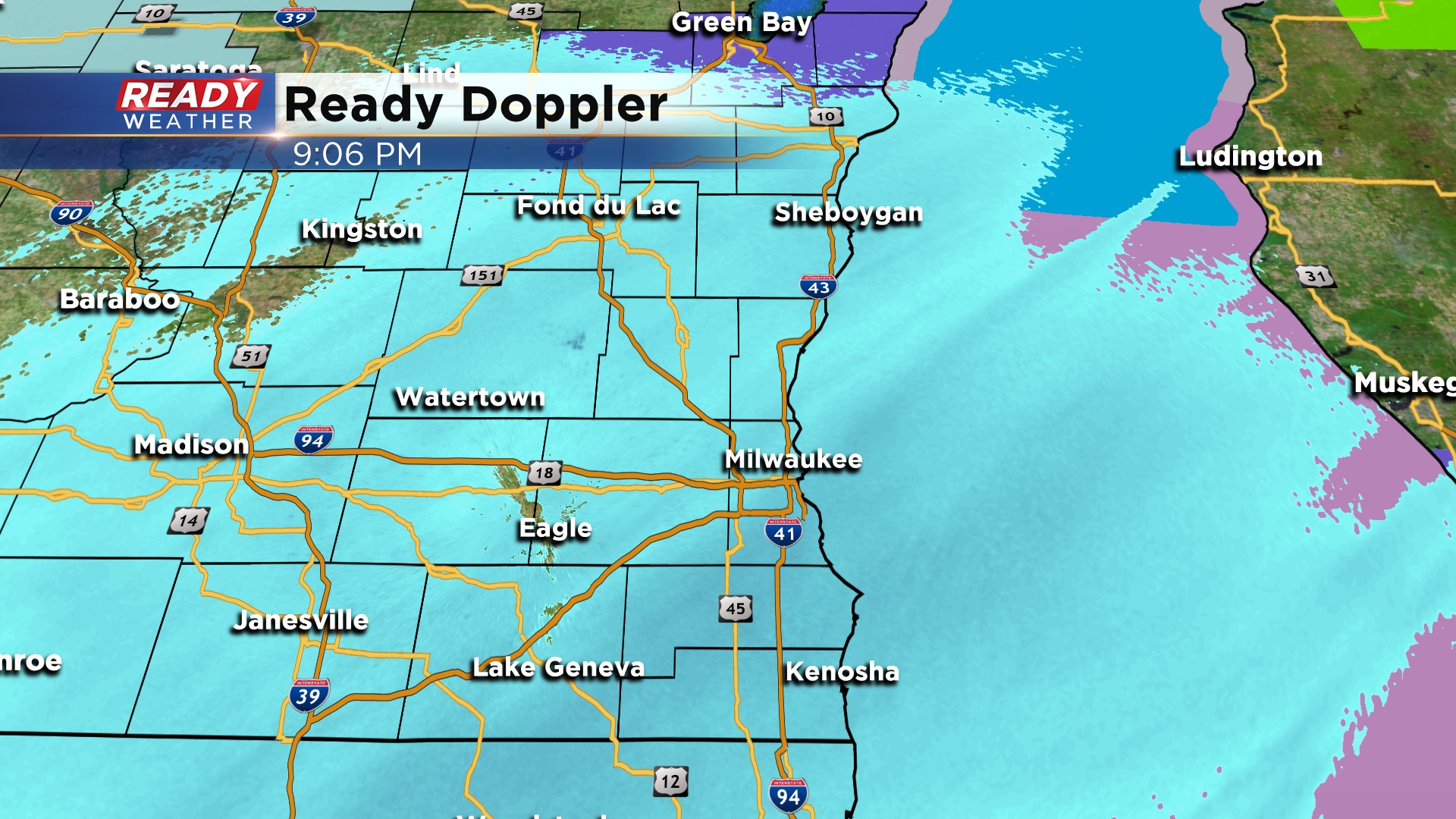
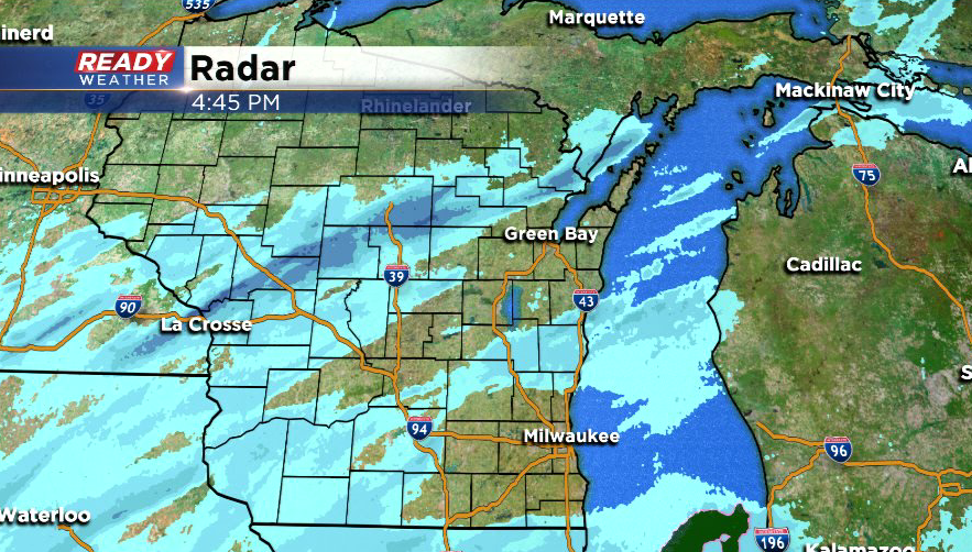
Light snow continues to fall across most of southeast Wisconsin. The accumulating snow will wrap up by 7 or 8 a.m. with up to an additional inch of snow possible. So far most of southeast Wisconsin has picked up 1-3" of snow.

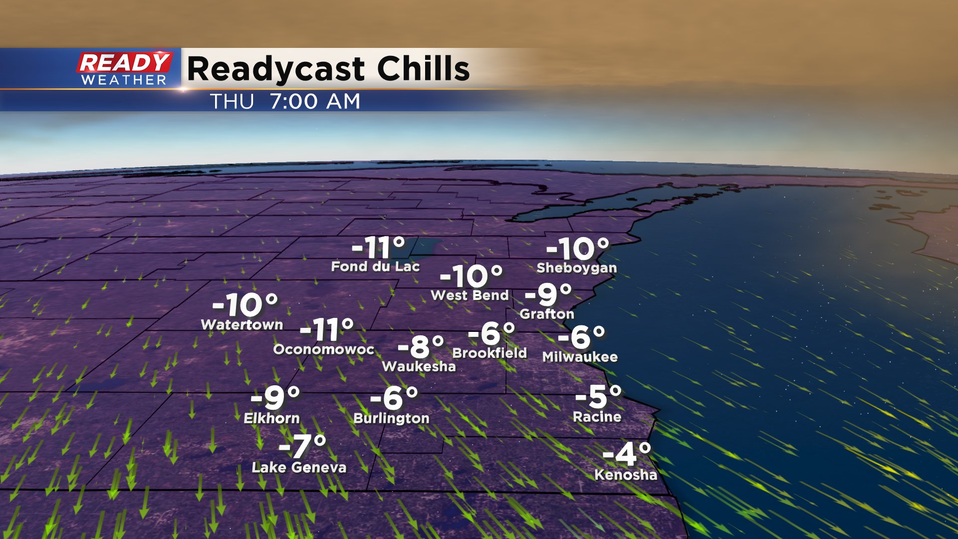
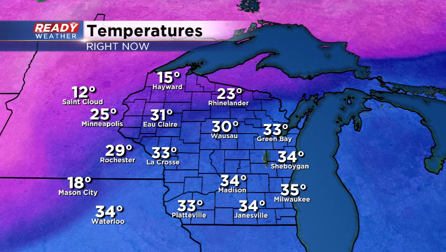
Temperatures continue to drop with many spots in the teens as of 4 a.m. and wind chills on either side of 0°. Wind chills will get as cold as -15° Thursday morning and then warm to around 0° by Thursday afternoon. Wind chills will drop to -20° by Friday morning. No wind chill advisories have been issued, yet.
------
Updated: 11:00 p.m. February 12, 2020
Temperatures by morning will fall into the single digits and the teens across the area. Wind chills will drop between -5 to -15 below! Slick roads are possible with the arctic air turning the wet streets into some ice. Use caution on driveways and sidewalks.
Some lingering snow is also possible for the early morning commute; however, it should be pretty light and not cause additional accumulation.
------
Updated: 9:00 p.m. February 12, 2020
No major reports of main roads being impacted by the snow. Thankfully surface temperatures are in the lower 30s, and that's helping to keep the interstates mainly wet. Side roads are slick in spots, so use caution there.
Snow will continue through early tomorrow with 1" to 3" possible.
The arctic front will arrive between midnight and 3 am. A quick drop in temperature overnight will create blowing and drifting snow along with slick roads for the morning commute. Wind chills will fall to -5 to -15 by morning!
------
Updated: 7 p.m. February 12th, 2020
Light snow is now reaching the ground across all of southeastern Wisconsin, reducing visibilities to around 2 miles.
So far, main roads are just wet as temps in most places remain at or slightly above freezing, but some less traveled side streets are starting to see a bit of accumulation. Temps will plummet into the teens behind the cold front overnight, with slippery spots expected for the morning commute.
Winds will continue to be from the southwest at 10-15 mph ahead of the cold front this evening but will turn to the northwest behind the front and gust up to 30 mph through mid morning Thursday. Arctic air will push in behind the front and be with us through Friday.
------
Updated: 5 p.m. February 12, 2020
Light snow has started reaching the ground near the WI/IL border, but isn't quite reaching the ground yet in parts of Sheboygan and Fond du Lac counties due to some dry air. The snow will overcome the dry air over the next couple of hours.
Recent model runs have come into a good consensus of 1-3" of snow across the area, with blowing and drifting expected through tomorrow morning.
The arctic cold front is making its way through northern Wisconsin right now and will push through our area between 10 p.m. and 2 a.m. from north to south.
---------------------------------------
Updated: 3 p.m. February 12, 2020
After starting the day with some sunshine, clouds have filled in ahead of a low pressure system tracking to the south and a cold front approaching from the north.
The forecast remains on track with snow overspreading the area this evening and picking up in intensity after midnight as the cold front sweeps through. A general 2-3" looks likely for the entire area, making roads slippery for the Thursday morning commute.
It'll be noticeably colder.when you head out to shovel Thursday morning, with wind chills below zero as winds gust to 30 mph. The wind will likely cause blowing and drifting overnight, especially in rural areas.
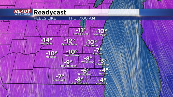
Temperatures and wind chills will be even colder Friday morning, with wind chills approaching -15°.
------
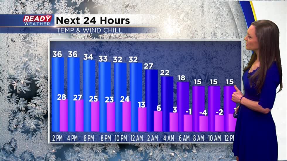
Updated 1 p.m. February 12, 2020
Snow is still on the way for this evening lasting through early Thursday morning. A solid 2-3" snowfall looks likely across the board. The cold is also looking inevitable, and in my honest opinion, that will be the biggest deal with this next event. Check out the temps and feels-like numbers the next 24 hours:
------
Updated: 9:53 a.m. February 12, 2020
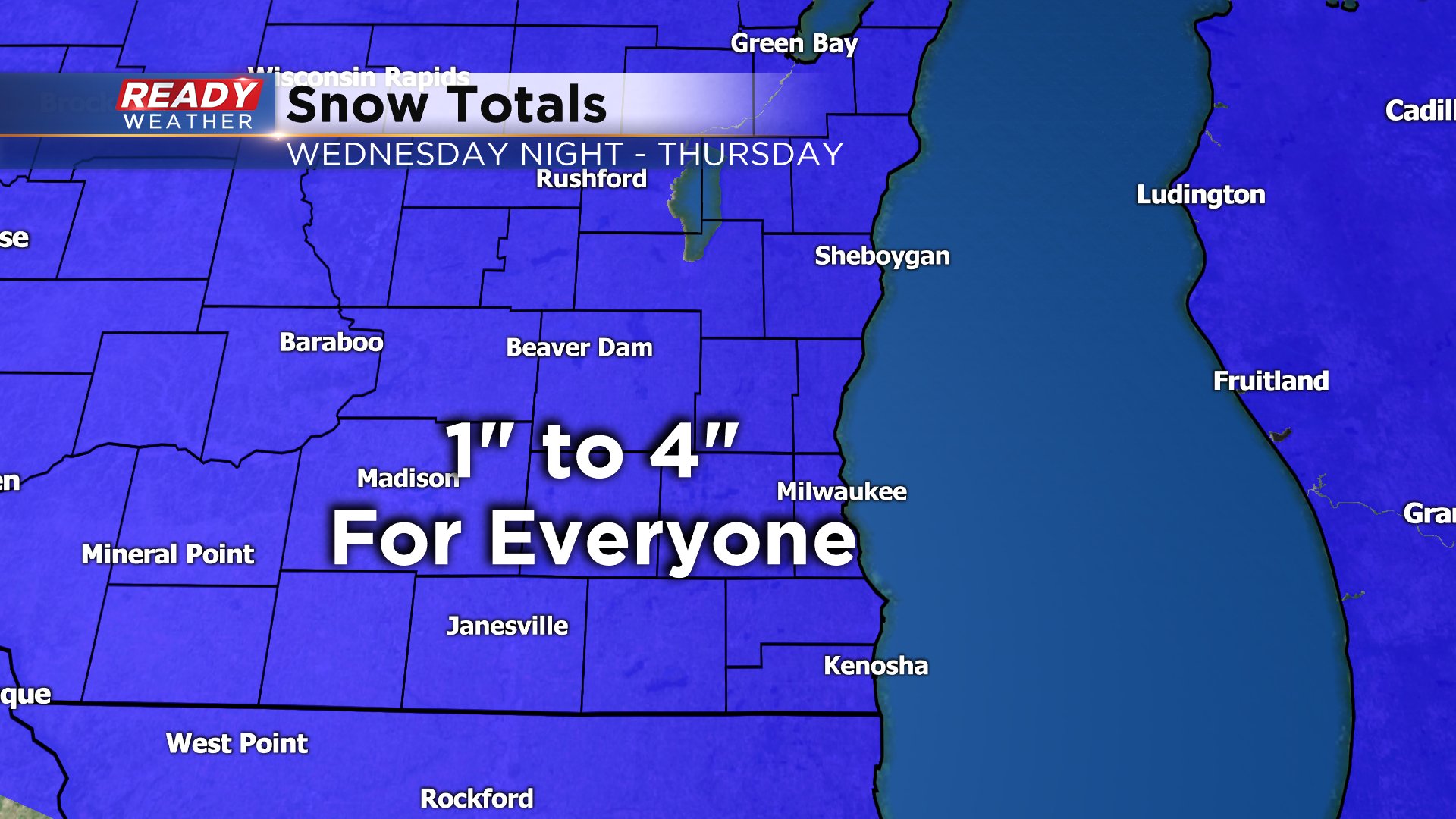
Our storm systems are on track with a low pressure approaching from the south and strong cold front moving in from the northwest. The storms collide bringing us a chance for snow after 6 p.m. although a few flurries could fly before that. The bulk of the accumulating snow happens overnight with 1-4" for most by Thursday morning and a few lingering snow showers through noon.

------
Posted: 6:04 a.m. February 12, 2020
Wednesday starts out like the previous days this week with sunshine and temperatures near average. Highs on Wednesday will be mild in the upper 30s. Clouds arrive in the afternoon with snow moving in just after the evening commute. Snow starts falling after 6 p.m. in most communities becoming steady by 11 p.m. with light to moderate snow falling overnight.

The bulk of the accumulating snow happens early Thursday with lingering light snow showers through noon. Snow totals look a little less than yesterday morning. More of a nuisance snow with 1-4" for everyone.
Our snow is the result of two different storm systems coming together. The first is a large low pressure storm to our south. It will drop 3-6" of snow across Central Illinois and Indiana where a winter weather advisory has been issued. Our snow is borderline advisory criteria but at this point none has been issued. The other storm system is a strong cold front to our northwest bringing snow and blizzard conditions across Minnesota and the Dakotas.

The cold front is also bringing bitter wind chills with wind chill advisories and warnings issued for most of Minnesota, Iowa and western Wisconsin. A wind chill advisory could be issued here for Friday morning but once again it is borderline on the criteria with wind chills to -20°.

Download the CBS 58 Ready Weather app to track the snow for tonight and cold to follow.