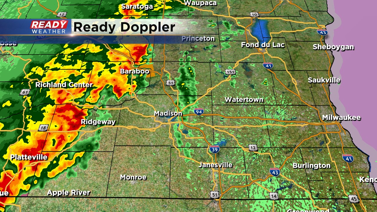
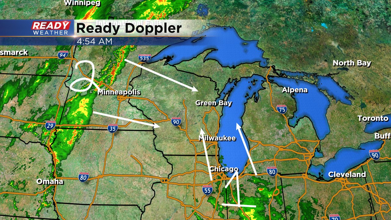
Late Monday Night Update: Storm threat exists into the overnight


Updated 11:00 pm Sept. 20, 2021
Some robust storms still west of the metro. They'll move through the area in the next hour or so. Gusty winds more than 60 mph will be the biggest threat. Heavy rain too.
_____________________________________________________________________________________________________________
Updated: 9:30 pm Sept 20, 2021
A severe thunderstorm warning has been allowed to expire. The warning was issued for Dodge county until 9:45 pm. The storm is moving northeast at 50 mph. Strong gusty winds remain possible.
____________________________________________________________________________________________________________
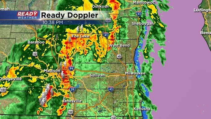
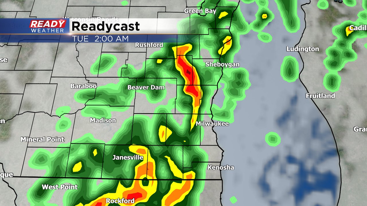
Updated: 8:30 p.m. Sept. 20, 2021
The line of showers and storms continues to move east. The timing is slightly faster than what we were looking at earlier in the day.
Western areas will start to see scattered storms closer to 10 pm compared to 11 pm. There have been a few warnings; however, the overall trend is for the line to weaken as it moves into southeastern Wisconsin.
______________________________________________________________________________________________________________
Updated: 5:30 p.m. Sept. 20, 2021
A line of strong to severe storms has setup across western Wisconsin right now. Storms will remain strong over the next several hours within a thunderstorm watch area.
We don't anticipate a watch to be issued for our area this evening. Those storms are expected to weaken as they move east. We still feel like the main line will arrive between 11 pm and 3 am. Gusty winds, small hail, and locally heavy rain will push through before the Tuesday morning commute.
_____________________________________________________________________________________________________________
Updated: 3:30 p.m. Sept. 20, 2021
Models remain consistent with a line of showers and storms to move through between 11 pm and 3 am.
The main threat will be gusty winds along with locally heavy rainfall. Widespread severe weather is not expected. An isolated strong to severe thunderstorm is possible into early Tuesday morning.
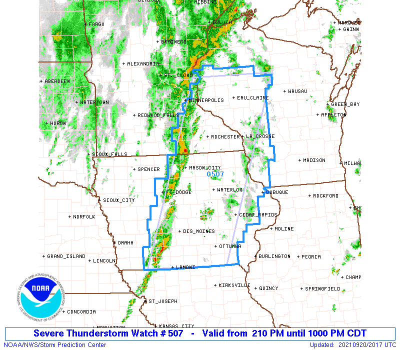
A severe thunderstorm watch has been issued for western Wisconsin until 10 pm. Any severe weather this evening will stay away from southeastern Wisconsin. The best ingredients for severe weather will remain within the watch.
______________________________________________________________________________________________________________
Updated: 1 p.m. Sept. 20, 2021
No changes in the overall forecast for tonight. Ahead of a cold front we do expect widely scattered showers and a few rumbles of thunder during the afternoon and evening; however, no severe weather is expected through the early evening.

The models move the main line through between 11 pm and 2 am from west to east. Scattered thunderstorms with heavy rain, small hail, and some gusty winds are possible.
The thought is the line will weaken as it moves east into our area. While a strong to severe storm can't be ruled out, widespread severe weather is not expected. The greatest severe weather risk will be west of our area.
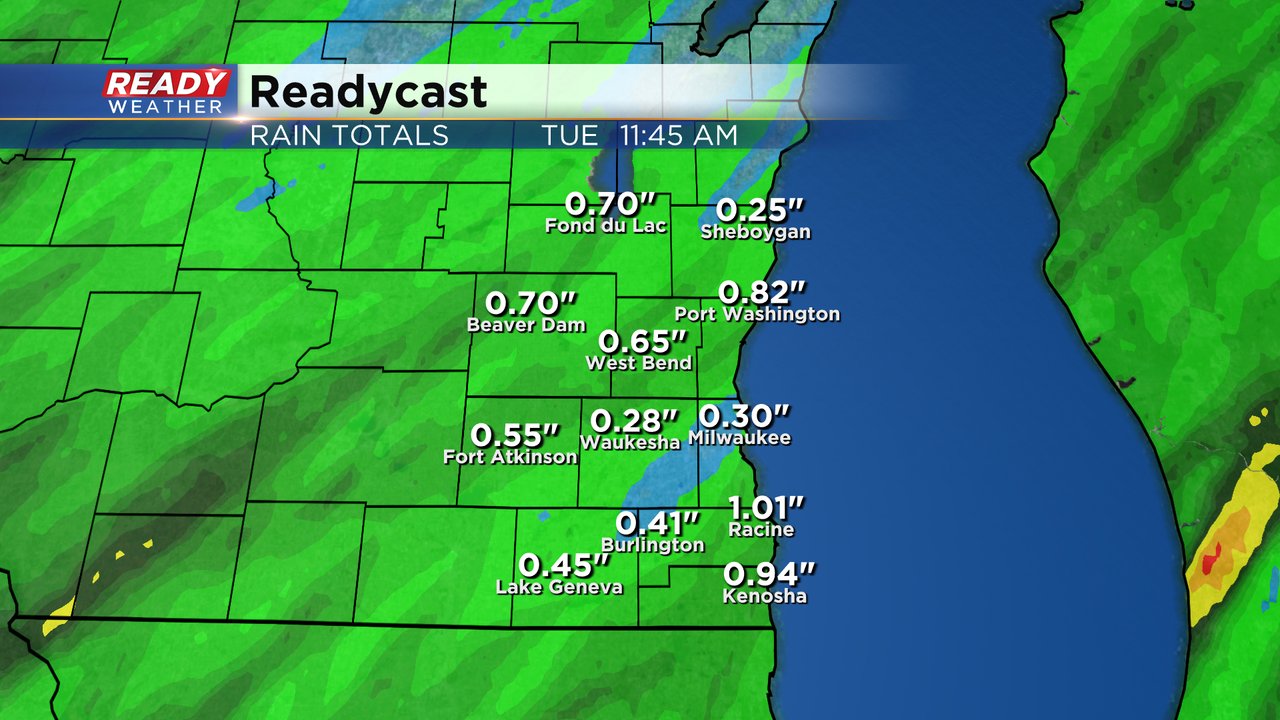
Rainfall between 0.25" to 1.00" is expected before the rain clears early Tuesday morning.
______________________________________________________________________________________________________________
Updated: 9:33 a.m. Sept. 20, 2021
A few light showers have moved into southeast Wisconsin from an area of rain mainly to our south. Those showers should remain fairly light and isolated most of the day with a chance for a storm. Expect a warm and humid day with highs around 80 and dew points hitting the tropical category. The better chance for storms is still tonight with a threat of severe weather. The forecast detailed below is still on track!
------
Posted: 7:06 a.m. Sept. 20, 2021
After a dry weekend with some fluctuating temps we bring back in the rain chance for Monday. We're watching two areas of rain. The first is down in Illinois and Indiana and moving north. A few isolated showers and storms will be possible during the morning and afternoon. At this point the evening looks dry before a line of storms out in Minnesota/Iowa move east and arrive in southeast Wisconsin Monday night into Tuesday morning.
The line of thunderstorms Monday night will likely be strong or even severe as it rolls across the state. There should be some weakening as the line moves into our area but some stronger or isolated severe storms are definitely possible. The timing of the stronger storms looks like 10 PM to 4 AM. A few showers could linger into Tuesday morning.
All of southeast Wisconsin is in at least the marginal (level 1) risk for severe weather. Central and western Wisconsin and eastern IA/MN are under the slight risk (level 2) for severe weather so they have a bit of a better chance. Damaging wind will be the main threat with any storms that develop. Some hail, heavy downpours and an isolated tornado can't be completely ruled out.
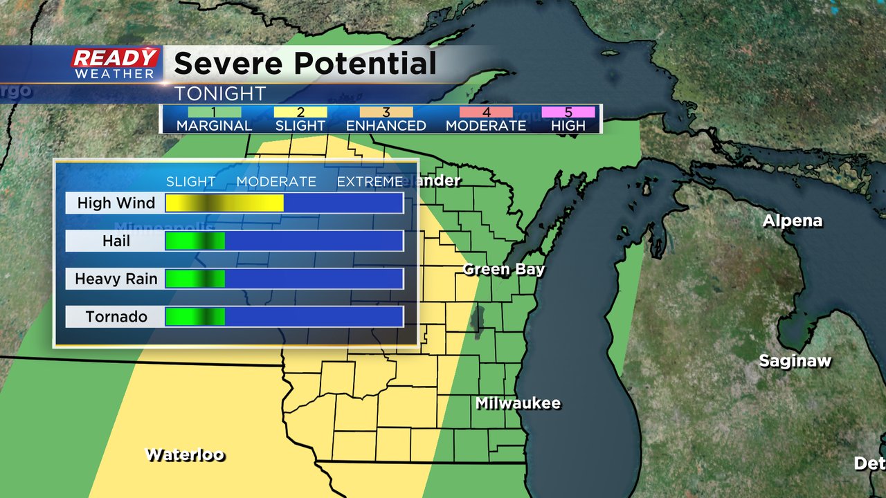
Don't expect much in rain totals with any showers or storms that happen during the day with less than a tenth of an inch expected but heavy rain is possible with the line of storms Monday night. A half to full inch is possible by the time the rain ends Tuesday morning.
Download the CBS 58 Ready Weather app to track the rain and get alerts if we do see some warnings.