Early Evening Update: Rain continues lakeside with wet snow falling inland


Updated: Friday, December 1st 6:00pm:
Warm waters of Lake Michigan plus onshore flow continues to keep precipitation all rain near the lake, while wet snow continues to fall inland. Western Milwaukee county has seen a mix of both rain and wet snow, but no accumulation.

Untreated roads are becoming slick west of Milwaukee county with more slick spots likely as the evening progresses due to falling temperatures. We're still expecting an inch or less of accumulation.
The precipitation intensity has come down since the afternoon. The back edge of the precipitation will continue to weaken and move out later this evening. Some drizzle is possible overnight.

---------------------------------------
Updated: Friday, December 1st 2:45pm:
Rain is beginning to transition to wet snow in many inland locations as of mid afternoon. Temps are also slowly beginning to drop closer to the freezing mark in these locations. While roads are just wet right now, but careful after sunset as temps drop even further, creating slick spots.

Still looking at about an inch of accumulation inland with little to no snow lakeside.
-----------------------------------------
Updated: Friday, December 1st 11:00am:
Cold rain has slowly been lifting northward this morning with a few wet snowflakes mixing in from time to time away from the lake. Temperatures overall are above freezing in SE WI so roads are just wet.

Precip will continue to slowly lift northward through the afternoon. By late afternoon and early evening, inland spots will start to cool enough for the rain to change over to wet snow.

This set up of wet snow inland and rain lakeside will continue into tonight before tapering off early Saturday.

The previous forecast remains on track for around an inch to inch and a half of wet accumulation away from the lake this evening through tonight, mainly on grassy surfaces.
---------------------------------------------------------------------
Updated: 9:03 a.m. Dec. 1, 2023
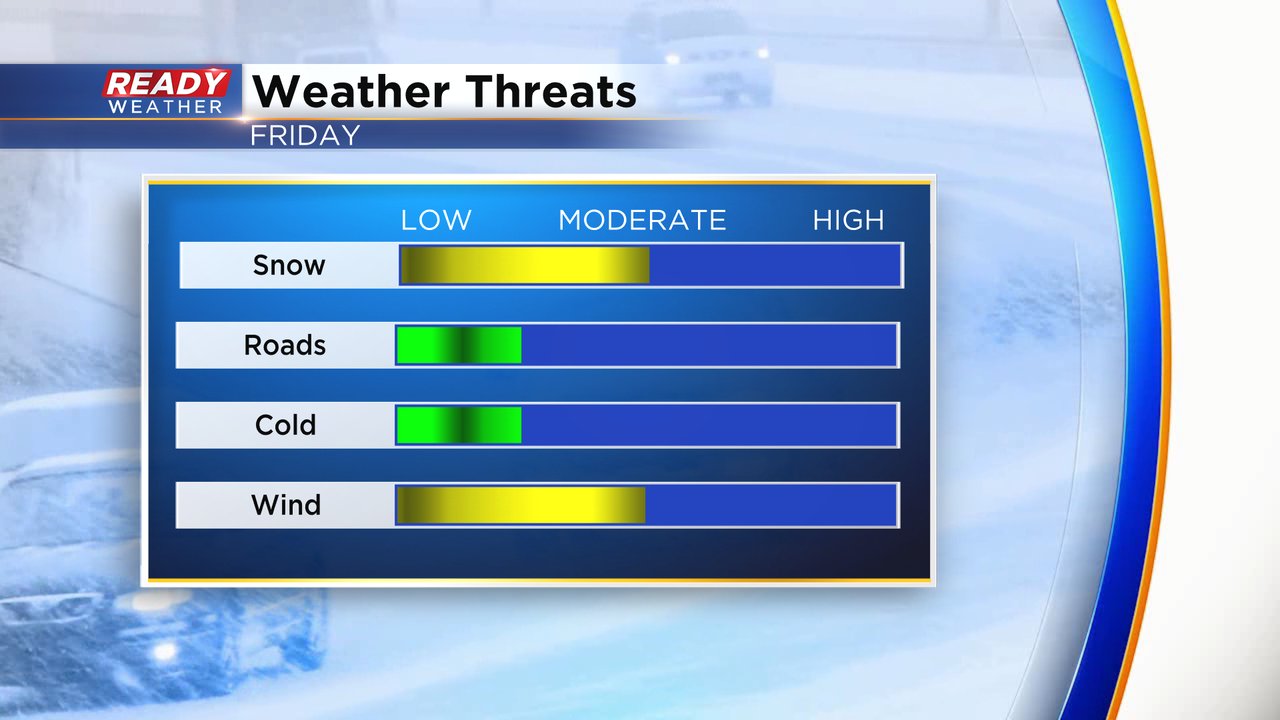
The rain has arrived in our southern counties with Walworth, Racine, Kenosha all seeing steady light to moderate rain. At times we've seen some raindrops get as far north as the I-94 corridor in Milwaukee and Waukesha. The snow so far has stayed away and probably will until the afternoon when accumulating snow around 1" is expected away from the lakefront. Roads should just stay wet so there won't be many travel concerns. No cold air associated with this storm but the wind could be gusty at times leading to reduced visibility.
------
Posted: 5:17 a.m. Dec. 1, 2023
The clouds have returned and will stay with us throughout most of the weekend with multiple chances for rain and/or snow. Friday morning that first round of precipitation is just across the border in Illinois but moving our way. Precip starts rolling into southeast Wisconsin by 7 AM with most of the local area seeing either rain or snow by noon.
Here's a radar image that will update with time:

With a northeast lake breeze and temps hanging out around 40 most of the day, lakeside communities will stay just rain especially in Milwaukee, Racine and Kenosha Counties and most of Ozaukee and Sheboygan Counties. But away from the lakefront will have a better chance to see a mix of rain and snow and even switching to just snow at times during the day.

Accumulating snow will stay to those inland and northern counties where up to around 1" of snow is possible. Most of this will stay on grass with roads staying just wet or a touch slushy.

The rest of southeast Wisconsin will see some decent rain with up to a half inch of rainfall possible to kick off December. Even communities that see some accumulating snow will also see a soaking rain.

Download the CBS 58 Ready Weather app to track the mix as it rolls in.