Rain to Snow....Strong Winds Return

Major changes in the forecast are coming over the next 48 hours. A storm system to our southwest will arrive on Wednesday, providing scattered cold rain across the area. Highs on Wednesday will struggle to get out of the lower 40s; however, as the storm departs, wrap around cold air will turn the rain into snow for Thursday morning.


The heaviest of the snow will likely occur between 3 am until 10 am Thursday. Wet slushy snow will cause some issues on the roads for Thursday morning including reduced visibility. By late Thursday morning the snow will likely mix with rain. The models move the mix out by early Thursday afternoon.
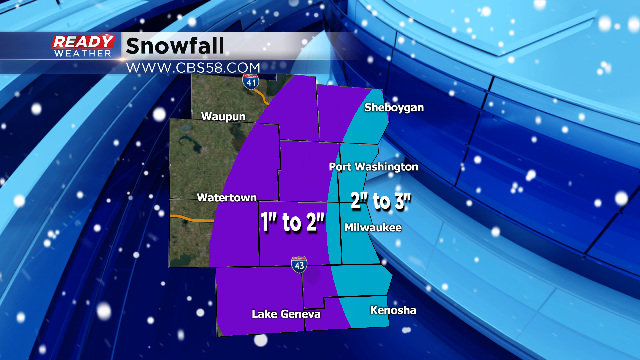
Overall accumulation will be highest along the lakefront with 2" to 3" possible. West of the lake areas will have a chance to pick up 1" to 2" of snow. There will likely be a sharp cutoff from east to west. Our western counties might completely miss out on the snow.
The other issue on Thursday will be the very high winds. A high wind watch is in effect for Milwaukee, Kenosha, and Racine counties for Thursday. Sustained winds between 20 and 30 mph are expected with gusts over 50!
