Severe weather outbreak possible across portions of Iowa and Illinois Saturday
A potent spring storm system is taking shape across the Central Plains and Midwest late tonight and into Saturday. An unseasonably pool of very humid air will move in from the south late tonight into Saturday across Iowa and central Illinois. Dewpoints in the 60s this time of the year are very rare across the Midwest; that type of humidity is much more common during our summer months.
A moderate risk of strong to severe storms are forecast across Iowa and Illinois for Saturday afternoon into the early evening. Showers and storms will develop tonight into Saturday morning across the moderate risk area; however, by early Saturday afternoon, sunshine will return to help destabilize the atmosphere within the moderate risk.
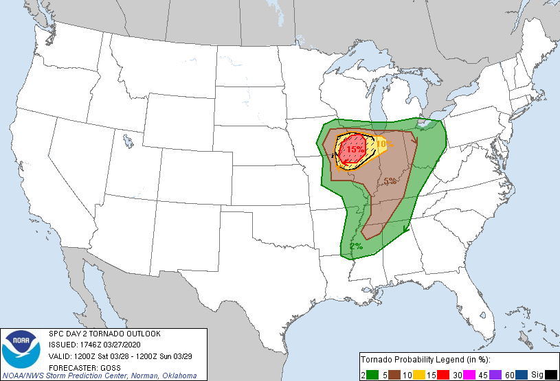
Wind shear will be extremely strong as a short wave of upper level energy develops to our southwest. Explosive storms capable of producing damaging winds, hail, and strong tornadoes are possible within the moderate risk. Notice the graphic above. A hatch of 15% is very significant for tornadoes.
Closer to Wisconsin the warm front will struggle to make it to the IL/WI border by Saturday night. The cooler lake along with waves of rain will help reinforce the boundary to our south. We are expecting scattered showers and storms throughout the day Saturday, but most will stay well below severe limits. Temperatures for most of the day tomorrow will remain in the middle to upper 40s on an east wind. Our high near 50 will occur closer to Midnight.
Expect a chance for a strong to severe storm right along the border of IL/WI Saturday evening if the warm front can nudge in from the south. We feel most of the severe weather will be confined to our west and south.
