Watching for Strong Storms on Saturday
The calendar may say fall, but our next storm system on Saturday will make it feel more like late spring. Scattered showers and storms will erupt across the area for Saturday afternoon into the evening, and some could become strong to severe.
The humidity will continue to push north late Friday into Saturday on strong south winds. Dewpoints in the low to middle 60s will be enough to fuel the storms on Saturday. The jetstream aloft will be very active creating the necessary lift for the storms to form.
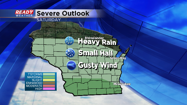
The SPC has put southern Wisconsin in the marginal risk for strong to severe storms. Storms that develop could produce small hail and very heavy rainfall; however, this type of setup will be more conducive for damaging wind gusts. In addition to the winds, we are expecting rainfall totals between 1 and 3 inches. Localized flooding could be possible under heavier rain producing storms
The storms will exit the area late Saturday night ahead of a cold front. Behind that front on Sunday expect breezy northwest winds and highs in the 50s!
Please keep your CBS 58 Ready Weather App handy this weekend. Your app will help alert you to any watches and warnings.
