Busy weather weekend with increased rain chances, big drop in temps

-
2:34

Milwaukee County healthcare contract expires leaving thousands...
-
1:00

Aggressive turkeys run ’a fowl’ in Janesville neighborhood
-
2:42

MADACC overwhelmed with pets; Milwaukee officials working to...
-
1:56

Hundreds attend “ICE Out“ protest in Milwaukee; Local businesses...
-
2:17

Miller High Life Theatre could be replaced by large convention...
-
1:17

Milwaukee couple says new renovated home in Metcalfe Park is...
-
2:07

UW-Milwaukee plans to merge 8 cultural centers into 1 student...
-
5:02

Consider taking a look in your jewelry box as gold prices hit...
-
0:45

Milwaukee High School of the Arts students host walkout to protest...
-
1:34

Crash closes all eastbound lanes of I-94 at Elm Grove Road in...
-
1:54

Monster Jam roars into Milwaukee this weekend for 3 shows
-
2:54

Adam Procell out as OCWS director; ineligible to hold the position...

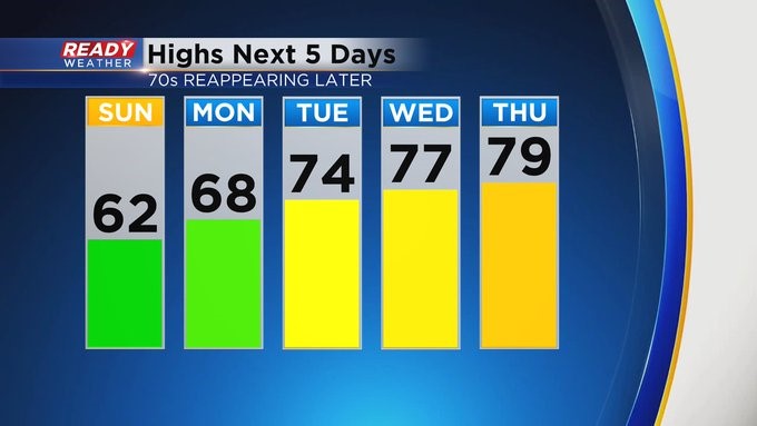
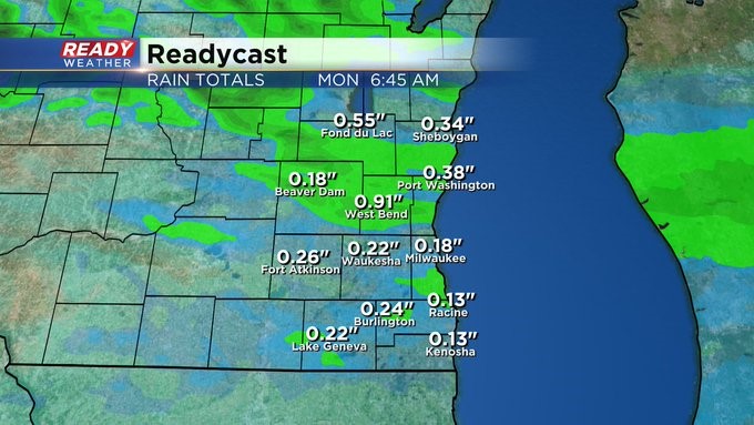
MILWAUKEE (CBS 58)--I know it's the weekend, and many of you don't want rain. But we're getting some. For what it's worth, a lot of it will fall overnight into early Sunday. A front will drop down from the north and trigger a few showers and storms by late in the day, especially north of I-94. Most of the precipitation should wrap up some point Sunday morning. Rainfall amounts will range between 1/4" and 1/2" for most.
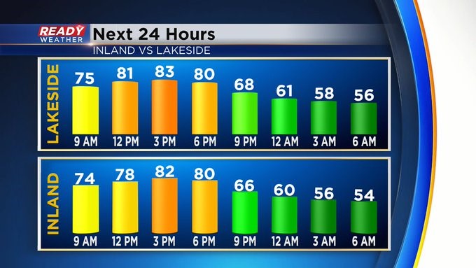
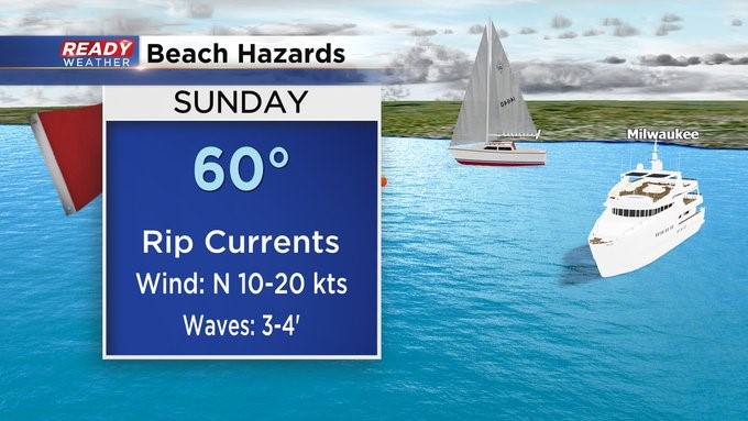
It'll turn sharply cooler into tomorrow, and the wind will stay high. In fact, there's a Beach Hazard Statement in place on Sunday for high waves and dangerous currents. Low pressure pivoting to the east early next week could trigger a few showers both Monday and Tuesday, and then a completely different system could pop a few showers and storms Wednesday afternoon into the evening.