Dense Fog Advisory Issued Until 10 AM Wednesday


Evening Update:
While the measurable precipitation has ended, drizzle and fog will remain an issue tonight. Low level moisture is trapped under the cloud deck lowering visibility across the area.
Inland areas will drop around 32 degrees, so light icing will likely continue in those areas. Lakeside areas will likely be ok with temps in the middle 30s.
______________________________________________________________________________________________________________
Afternoon Update:
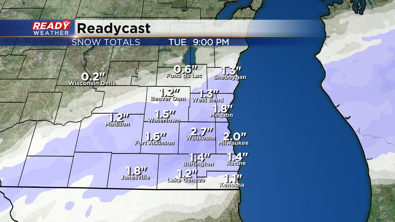
Milwaukee is sitting at 38 degrees, the warmest through the area. Downtown is mainly rain and conditions mostly wet there. Additionally, major freeways in the county are decent and slippery stretches continue inland as locations away from the lake are mostly at the freezing mark. Starting to see more snow take over inland, but the later onset of the white stuff means maybe an inch is more likely with isolated spots to 2". Look for about a tenth to quarter inch of rain for Milwaukee and points south along the lake.


Updated: 10:04 a.m. Jan. 23, 2024
Wintry mess and mix is still ongoing across most of southeast Wisconsin. Fond du Lac County has not really picked up much but Sheboygan County is starting to see snow. North of I-94 it's mostly a snow and sleet mix and south of I-94 is mostly rain, freezing rain and sleet. We are starting to see more pockets of snow show up, especially west of Madison. That slow switch to all snow will continue over the next few hours. All snow is expected for most of southeast Wisconsin by the afternoon.
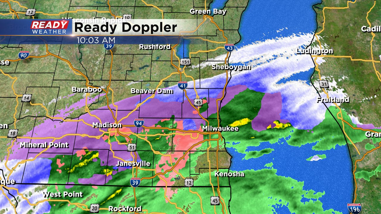
Even though air temps for many areas are still around or above freezing the road temps are still cold which is why we are still seeing a lot of icy roads. As the temps continue to warm throughout the day Tuesday the chance for mix and ice will go down and the wet snow threat goes up. We are still expecting up to 2" of wet snow for most of southeast Wisconsin with isolated communities getting closer to 3".
Here's a look at temps that will update with time:

------
Updated: 7:05 a.m. Jan. 23, 2024
Wintry mix continues to roll into southeast Wisconsin. So far our southern half of counties are the ones seeing the precpitation mix of sleet, freezing rain, snow and rain. That mix will likely continue through the morning commute and into the late morning then switch to all wet snow the rest of the afternoon with 1-3" of snow expected today.
Here's a radar image that will update with time:


Here's a look at the winter roads conditions from the DOT that will update with time:

------
Posted: 5:01 a.m. Jan. 23, 2024
Another round of wintry mix is here. Fog, freezing fog and freezing drizzle all formed Monday night and roads are icy and slippery all across southeast Wisconsin. Sidewalks, driveways and neighborhood roads will likely be very slick. Freeways should be in a bit better shape but ramps, bridges and overpasses will likely be icy.
In addition to the freezing fog and drizzle an area of wintry mix is currently rolling in from the south. Sleet, freezing rain, snow and plain rain are all falling and moving north. The wintry mix will mainly impact areas along and south of I-94 but slick spots will still likely happen in northern counties.
By late morning or around noon the wintry mix will switch over to just snow. That snow will be wet and heavy and will last through the late afternoon or early evening hours. The evening commute will likely be slick with snow covered roads and a layer of ice underneath.

Wet snow will accumulate to 1-3" across most of southeast Wisconsin with a few communities not quite reaching the 1" mark.
A winter weather advisory has been issued for Tuesday's round of weather. The advisory is mainly for the chance for wintry mix and ice that could leave a glaze of ice on most surfaces. That advisory goes until 2 PM Tuesday even though wet snow will likely linger beyond that time.

Download the CBS 58 Ready Weather app to track the morning wintry mix and when it switches to snow.