Mid Evening Update: Severe Thunderstorm Watch issued until midnight


Updated: Friday, July 28th 8:25pm:
Storms continue to strengthen in southeast Wisconsin with two severe thunderstorm warnings in effect in Walworth, Racine, and Waukesha counties. These storms have a history of producing between half dollar and ping pong sized hail in Mukwonago. They're slowly tracking east-southeast at 20 mph.

In addition to these storms, we're also watching a complex of severe storms tracking in from the northwest. This line has a history of strong winds and very large hail. This would reach Dodge and Fond du Lac counties around 9:30pm and the Milwaukee metro around 10:30pm if it holds together.

------------------------------------------------------------
Updated: Friday, July 28th 6:35pm:
A Severe Thunderstorm Watch has been issued for Fond du Lac, Dodge, Jefferson, and Walworth counties until midnight.

Other counties east of there are not included in the watch because of the lake breeze. This lake breeze has tracked all the way into the counties in the watch, meaning it has helped make the air more stable from Waukesha eastward. We are still expecting storms area-wide this evening, but they should weaken once they cross over the lake breeze.

----------------------------------------------
Updated: Friday, July 28th 5:10pm:
All is quiet right now in southeast Wisconsin, but we're starting to see a few isolated showers and storms attempting to develop in northern Iowa and southwest Wisconsin.

Multiple severe thunderstorm watches have been issued to our west. We'll likely see one issued later this evening. Right now it looks like the main time frame for the worst of the storms will be between 8pm-11pm.

-------------------------------------------
Updated: Friday, July 28th 2:15pm:
The beautiful sunshine is helping to destabilize the atmosphere after the rain early this morning. Plenty of heat and humidity out there right now to fuel rapid storm development this evening.

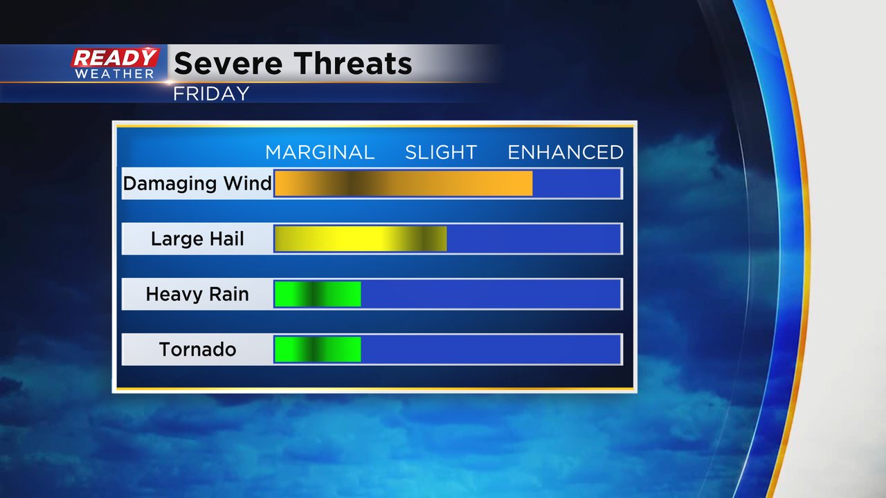
There is still some uncertainty as to when the storms will begin. Some data suggests storms arriving as early as 6pm, but others keep the storms at bay until after 9pm. Main takeaway is you'll need to be weather aware all evening and have a plan to shelter if you'll be out at one of the many festivals going on this evening. Damaging wind continues to be the primary threat along with hail and torrential downpours. The tornado threat remains low, but isn't zero.

Download the CBS 58 Ready Weather App to get any watches or warnings sent to your phone.
--------------------------------------------------------------
Updated: 12:15 p.m. July 28, 2023
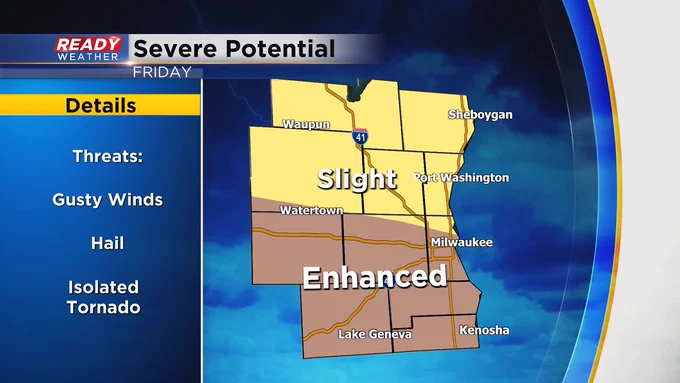
Strong storms are looking inevitable this evening. The only kink we continue to monitor is the start and end times. Two reliable short term models either start storms working from our west locations to the lakefront from 5-7pm or 7-9pm. No matter which solution pans out both bring strong storms through nearly the entire viewing area. The one change from the Storm Prediction Center is the latest update shifts the enhanced (level 3 of 5) risk for severe storms a bit north to now include most of Milwaukee county.
Updated: 9:13 a.m. July 28, 2023
The clouds are starting to thin out and the heat and humidity are building back in. There are no changes to our expectations for severe weather Friday evening. Timing looks best between 5 PM and Midnight. Damaging wind will be the main threat along a line of storms that develops but a few areas with hail or heavy rain are possible. The tornado threat is very low but not completely 0. Our southern counties remain in the Level 3 Enhanced Risk with a Level 2 Slight Risk for most of the rest of southeast Wisconsin.

Make sure to download the CBS 58 Ready Weather app to get alerts when watches or warnings are issued.
------
Updated: 6:03 a.m. July 28, 2023
Our first round of showers and a few isolated storms is ending. There are still some lingering showers out there but most of it should end by 9 AM. The rest of the morning and afternoon looks dry with storms returning after 5 PM.
Here's a radar image that will update with time:

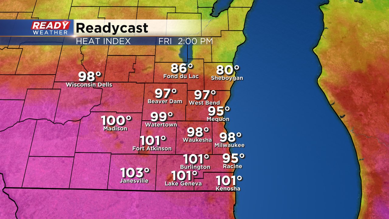
The heat and humidity of the day will increase the fuel thunderstorms can tap into to become strong to severe. For the second day in a row a heat advisory has been issued for Jefferson and Walworth Counties. The advisory starts at noon and lasts until 8 PM.
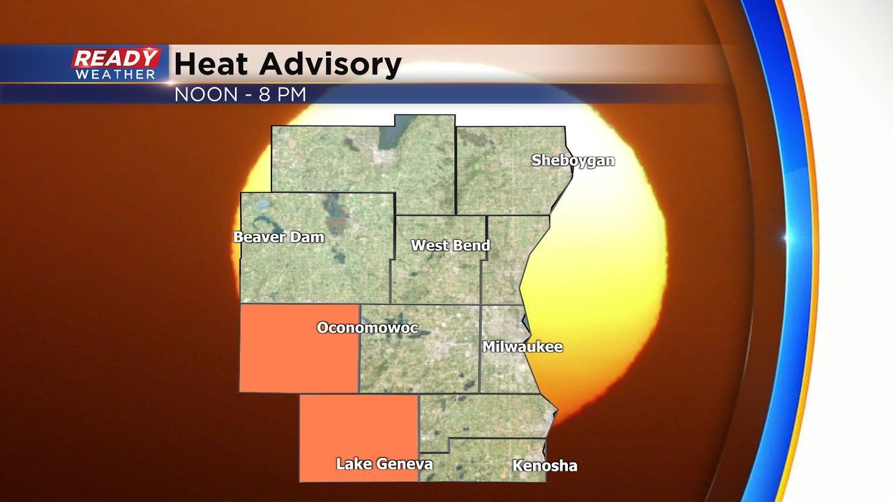
Peak heat indices in these counties have the best chance to hit 100 but it's still going to be hot for everyone else with feel like temps reaching the upper 90s in many communities.
The storm forecast written below still holds for Friday evening.
-------
Posted: 4:46 a.m. July 28, 2023
The heat and humidity will hang on for one more day with feels like temps on Friday reaching the upper 90s to around 100* in many hometowns. All of that warmth is going to give fuel for thunderstorms. Our first round of rain Friday morning has so far behaved. A strong storm rolled through Fond du Lac and Sheboygan Counties around midnight but the rest of us have just seen some rain with an isolated rumble here and there.
After we dry out from mid-morning through the late afternoon with temperatures surging we get another chance for storms this evening. The best chance for strong to severe storms looks to be after 5 PM.

Any storms that do develop could be severe. The Storm Prediction Center has added parts of southeast Wisconsin, especially south of I-94, to the Level 3 Enhanced Risk. Most of the rest of our area is in the Level 2 Slight Risk with northern parts of Fond du Lac and Sheboygan Counties in the Level 1 Marginal Risk.

Damaging wind will be the main threat with any storms that do develop Friday evening. Some hail is also possible but the tornado threat is near 0 and while heavy rain is a possibility, major flooding is not expected.
Download the CBS 58 Ready Weather app to get alerts if watches or warnings are issued today and to track the storms with the interactive radar.