Thursday Mid-Morning Update: Snow is over but wind is picking up


Updated: 8:48 a.m. Feb. 15, 2024
The snow for Thursday morning is over. Snow totals ranged from a dusting to an inch in southern counties to 1-3" in the Milwaukee/Waukesha Metro then 2-5" in our northern tier of counties.

Pockets of sunshine have been quick to emerge already Thursday morning and it will continue to get sunnier as the day goes on. High temps Thursday will reach the upper 30s and with lots of afternoon sun will result in a lot of melting snow. The wind will also pick up with gusts to 30 mph Thursday then still breeze for Friday with the wind picking back up out of the west on Friday.

Download the CBS 58 Ready Weather app to track the wind and some cooler temps.
------
Updated: 7:10 a.m. Feb. 15, 2024
The snow has pretty much wrapped up across most of southeast Wisconsin. Road conditions are starting to improve for most of our local area but neighborhood roads and side streets are still slushy and snow covered in many areas.
Here's a look at road conditions on the freeway from the DOT that will update with time:

The first snow reports of the morning are coming in. Less snow fell in southern counties especially south of I-94 with mostly less than or around an inch. Northern counties are already reporting 1-4" of snow.

A lot of the slush will melt Thursday afternoon as sunshine returns!
------
Updated: 4:48 a.m. Feb. 15, 2024
Snow was coming down thick and heavy early Thursday morning and quickly accumulating. As of 5 AM the roads are in pretty rough shape and very slow. At times the snowflakes were the size of dinner plates. Roads will quickly improve as the rate of snowfall slows down.
Here's a radar image that will update with time:

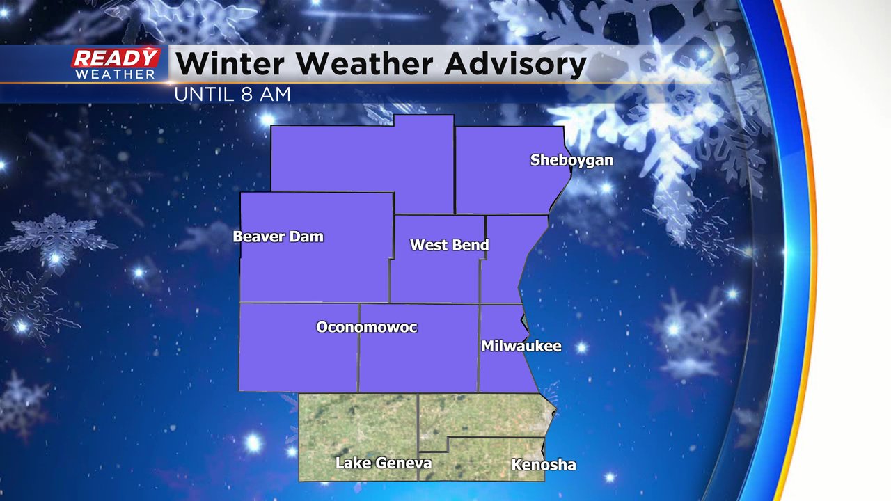
New Thursday morning, Milwaukee County was added to the winter weather advisory until 8 AM. Everyone in southeast Wisconsin except Walworth, Racine and Kenosha Counties have now been included in the advisory. Those in the advisory have the best chance to see 2-5" of slushy snow and slow driving conditions.
Download the CBS 58 Ready Weather app to track the end of the snow.
------
Updated: Wednesday, February 14th 8:30pm:

The NWS has extended the winter weather advisory to include Jefferson and Waukesha counties. The computer models have shifted the higher totals further south, so those areas could experience several inches of wet, slushy, snow.
______________________________________________________________________________________________________________
Updated: Wednesday, February 14th 4:00pm:
Only small tweaks have been made to the rain/snow map. The transition zone, which is either side of I-94, has been pushed a few miles farther south.

Rain and snow move in around midnight and exit by 8am. The heavy snow will fall during the overnight hours with impacts north of I-94 lingering into the morning commute. Roads will likely only be wet/slushy in the Milwaukee metro.
-------------------------------------------------------------------
Updated: Wednesday, February 14th 1:30pm:
The Winter Weather Advisory has been expanded to include Ozaukee county and now runs through 8am Thursday.

Moderate to heavy snow will quickly pile up before sunrise with 2-5" of accumulation expected. I-94 continues to looks like the transition zone between snow and rain, so this area will probably see periods of both.

------------------------------------------------------------------
Snow (and some rain) is on the way for the first time in three weeks across southeast Wisconsin. The last time we had accumulating snowfall was 22 days ago on January 23rd. You have to go back another 10 days to find over an inch of snowfall on January 13th at the end of that big storm that rolled in.
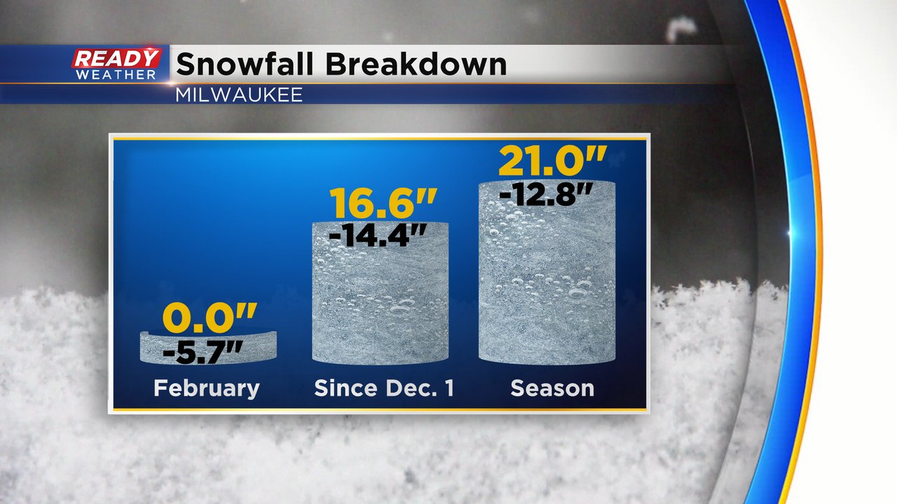
So far this February we have not had any accumulating snow and the snow deficit for meteorological winter and the entire season is really piling up. We would need a few good storms in order to make up that deficit.
Milwaukee may or may not get some accumulating snowfall for Thursday morning. A band of fast and heavy snowfall does look likely across part of southeast Wisconsin but that swath of heavy snow looks best in our northern counties. Along and south of I-94 will mostly stay rain with a little snow mixing in.

In those northern counties a winter weather advisory has been issued. Fond du Lac, Sheboygan, Dodge and Washington Counties are under the advisory from midnight to 6 AM Thursday morning.

Snow totals in those northern counties are likely over 2" with some areas as much as 5". North of I-94 could get a slushy inch or two with mostly rain and mix in those southern counties.

Even though snow totals are not overly impressive the snow will likely come down fast and heavy at times, especially before 7 AM, which will make roads difficult for the early morning Thursday commute. The wind picks up as the snow ends. No cold air to worry about with this storm.

Download the CBS 58 Ready Weather app to track the rain and snow on the way for Wednesday night and Thursday morning.