The severe weather threat is over. Chance for some showers this evening.
Updated: 4:30 p.m. April 2, 2025
High temperatures will likely occur later this evening as the winds turn out of the southwest; however, the main ingredients for severe weather never materialized.
There is a line of showers that has developed to our west, but lingering rain and cloud cover limited any CAPE from developing. Without that CAPE, the updrafts from the showers can't sustain themselves. They are basically getting torn apart from strong winds aloft.
This is a very tough time of the year to experience significant severe weather. Warm fronts tend to get pushed south into northern Illinois from the lake.
_________________________________________________________________________________________________________
Updated: 12:15 p.m. April 2, 2025
Our threat for severe weather appears to be dropping, thanks in part to all of the rain we have seen this morning.
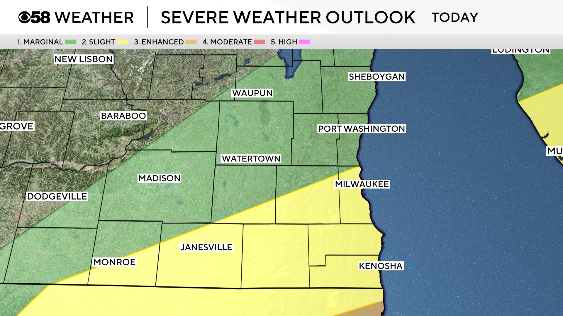
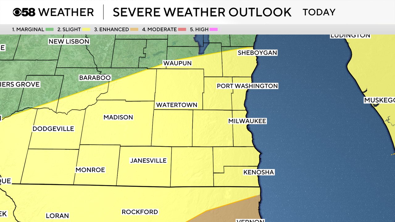
The latest midday update from the Storm Prediction Center has dropped the Level 2 risk down to just a Level 1 risk:
This does not mean we are totally free and clear of storms. It's quite possible that we see some isolated pop-up storms between 3pm and 7pm today. This will depend upon seeing sunshine and how close the incoming warm front will get.
Our latest computer model shows the radar may look like this around 5pm today:
We will continue to monitor the radar and provide updates on-air and online as needed.
-------
Updated: 10:43 a.m. April 2, 2025
The morning round of heavy rain and storms has just about ended. Just a few light to moderate showers are out there now. Those could continue in some locations through the early afternoon then we have a chance to dry out for a few hours before another round of storms is possible from 4-8 PM. That dinnertime round of storms is highly conditional with best chances in areas south of I-94 and close to Lake Michigan.
Here is a radar image that will update with time:
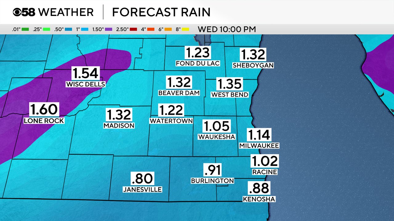
The morning round of rain and storms did bring with it some heavy rain with most of southeast Wisconsin getting 0.50-1" of rain. We still have the potential to pick up another half inch or even close to an inch in spots with any additional thunderstorms we see.
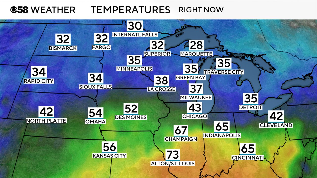
We are also watching the location of a warm front. That front has now made it through central Illinois and is moving north. If that front reaches southeast Wisconsin it would increase our potential for those dinnertime strong to severe storms. And it will allow temps to warm into the 60s to around 70 degrees.
You can see the front clearly on the regional temperature map. Areas in the 60s and 70s are on the warm side of the front while we stay on the cooler side, for now...
The rest of the forecast highlighted below, including our severe risk and threats remains on track.
------
Updated: 9:10 a.m. April 2, 2025
The morning storms and heavy rain are in full force this Wednesday morning. So far storms have stayed below any severe limits but frequent lightning strikes have been common and some small hail has been reported here and there. It looks like the morning round might be calming down a bit with some pockets of dry time the next few hours. There is still a chance for some stronger storms around noon and then another round of storms in the late afternoon and early evening.
An update to the Severe risk for Wednesday has taken northern counties out of the Level 2 Slight Risk but it remains for southern and southeast areas that have the better chance to see some late afternoon and evening storms.
The bullseye for severe weather today is far to our south where parts of the country are under a rare Level 5 High Risk for violent tornadoes.
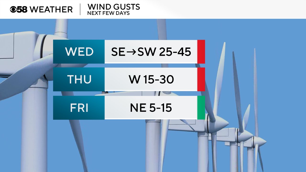
In addition to all of the rain, it has been very windy with gusts at times reaching 40 or 45 mph. Those strong wind gusts from 25-45 mph will be possible most of the day Wednesday. The wind stays strong Wednesday night and Thursday with gusts to 30 mph then finally calms down for Friday from 5-15 mph.
We will also be tracking a warm front closely throughout the day. This front is currently barely into southern Illinois so it's got quite the distance to cover. Many weather models do have the front arriving in Wisconsin but not until the late afternoon and evening when temperatures will warm into the 60s or even around 70. Some of our North and Northeast counties might not see the warm front until after sunset so highs there probably top out in the 50s.
The rest of the forecast and rain amounts and severe threats highlighted below remain on track.
------
Posted: 5:49 a.m. April 2, 2025
It is a wet start to your Wednesday. What started with a little bit of wintry mix, rain and snow Tuesday evening into early Wednesday morning has started to transition to all rain. So far we haven't seen many thunderstorms, but that will change after sunrise when thunderstorms become more possible.
One question in the forecast is how much dry time we get in the afternoon hours. The more dry time, and especially any sun we get, could fuel a final round of storms in the late afternoon and the evening. The best chance for those storms in the late afternoon and evening will be south of I-94 and mainly towards the Illinois border.
We are still expecting a lot of heavy rain Wednesday with most of southeast Wisconsin getting at least 0.75" and some areas closer to 1.50" or even 2" for those that see multiple storms. While the ground is fairly water logged, the rivers are relatively low, so major flooding is not expected but some minor flooding or ponding on area streets and freeways is possible.
The Severe Outlook for Wednesday has decreased a bit from Tuesday morning. The Level 3 Enhanced Risk stays in northern Illinois. Most of southeast Wisconsin remains under a Level 2 Slight Risk for the potential for some strong and isolated severe storms both in the morning as well as any storms that develop around dinner time.
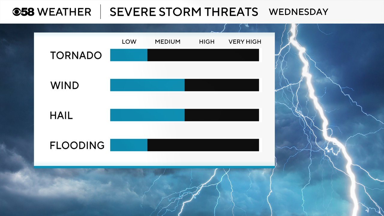
The severe threats for Wednesday have not changed much. While tornadoes do not look likely, they cannot be completely ruled out. For any morning strong storms, hail will be the primary threat and strong wind will be the biggest threat with any afternoon or early evening storms. There is a minor flooding threat as well.
Download the CBS 58 Weather app to track the rain and storms all day.


