8:30pm update: Snow rates, wind increasing for the afternoon and evening


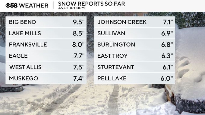
10:00pm Update:
6" of snow is looking to be on the lighter side now as places like Big Bend have jumped up to see 9.5" of snow tonight! Moderate to heavy snow is still falling with up to 4" of accumulation still possible. Visibility is improving the further inland and south/west of the city you are. Gusty winds, however, are still strong near the Lake keeping road conditions tough.
Snow will fall through tomorrow morning, and after the snow wraps, gusty winds will still hold. This will keep visibility reduced and travel can still be tough at times as fallen snow can blow around. Cold air is to follow to begin he work week.
8:30pm Update:
Moderate to heavy snowfall is now moving in for all. The farther north you are the warmer that temps are still holding making for a messy mix. Icy roads have developed as well as gusty winds along the Lake. Visibility has improved areas southwest as the bulk of the system makes its' way to the northeast. About 12 hours left of this system before we dry out. Then the winds pick up from there allowing for snow to keep blowing around most of the day tomorrow. Stay safe!

6:00pm Update:
Muskego is now up to 7.4"! Not a ton of changes in the forecast, just please be careful on the roads.
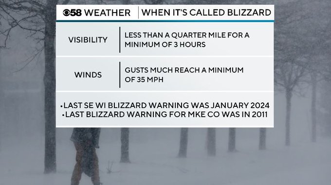
Some positive news while we are in the worst of the system is that we are continuing to stay away from blizzard threshold. While still dangerous on the roads with blowing snow, our current wind gusts are under 30mph with visibility anywhere from 0.5-1 mile.
4:30pm Update:
Visibility is still very reduced with the heaviest band of snow holding mostly areas southwest of the City. This heavy band is making its' trek north and will impact north of MKE by late this evening! So far some places southwest have already seen about a half a foot of snow! Winds have also picked up with gusts close to 30mph creating blowing snowfall and making it tough to see outside. Stay safe!

2:15pm Update:
Heavier snow has started to fall, meaning we have just begun the worst of the system now. Wind gusts have also picked up with current gusts to 25mph which is starting to make it pretty tough to see on the roads with visibility less than a quarter mile.
Temperatures are still currently less than 32 degrees, but any slight warming in temps could allow for melting and refreezing making icy spots possible. Now is a great time to start shoveling!

12:15 PM Update on Saturday, November 29...
Slow and steady with the snow so far. But expect the intensity to increase for the afternoon and evening as moisture comes in from the southwest. An inch an hour with the snow rate is possible. This means a reduction in visibility, making traveling even more treacherous. Please drive with extreme caution. I still think we're on track for 6 to 10 inches of snow if not more. Stay tuned throughout the day for updates on air and online.


______________________________________________________________________________________________________
10:15 AM Update on Saturday, November 29...
It always seems the onset of these big winter storms is the worst time for the roads. This appears to be the case right now. Getting reports of numerous spinouts and cars in ditches. Please slow your speed and watch for snowplows too. The snow and eventually the wind will increase as we go through time this afternoon and evening.


_________________________________________________________________________________________________
8:15 AM Update on Saturday, November 29...
The snow is taking hold, making for a lot of slick spots across the area. Expect 6 to 10 inches of snowfall, at least, between now and early Sunday. The Winter Storm Warning holds until 6 AM Sunday. I'm watching the weather situation carefully. Look for updates all day long right here on CBS 58 and online too.


__________________________________________________________________________________________________
MILWAUKEE (CBS 58)--Get ready for a blast of winter weather these last few days of November. We're talking at least 6 to 10 inches of snow with higher amounts certainly possible. Lake enhancement is expected to keep the totals down a bit lakeside. Unfortunately, winds will be an issue perhaps creating blowing snow and whiteout conditions through Sunday. Also, through 6 AM Sunday, will be a Winter Storm Warning across the entire viewing area. Once we get past this storm system, we'll have a few more clippers to content with this coming week, mainly midweek and into next weekend. Look for snow chances during these times but not what we'll be dealing with this weekend. Stay tuned to CBS 58 on air and online. We'll keep you updated.


Something to watch...


