Afternoon update: Snow has come to an end with rain and drizzle lingering into the evening
Updated: Thursday, November 21st 2:20pm:
The snow has come to an end as warmer temps above freezing has changed the snow over to rain and drizzle.
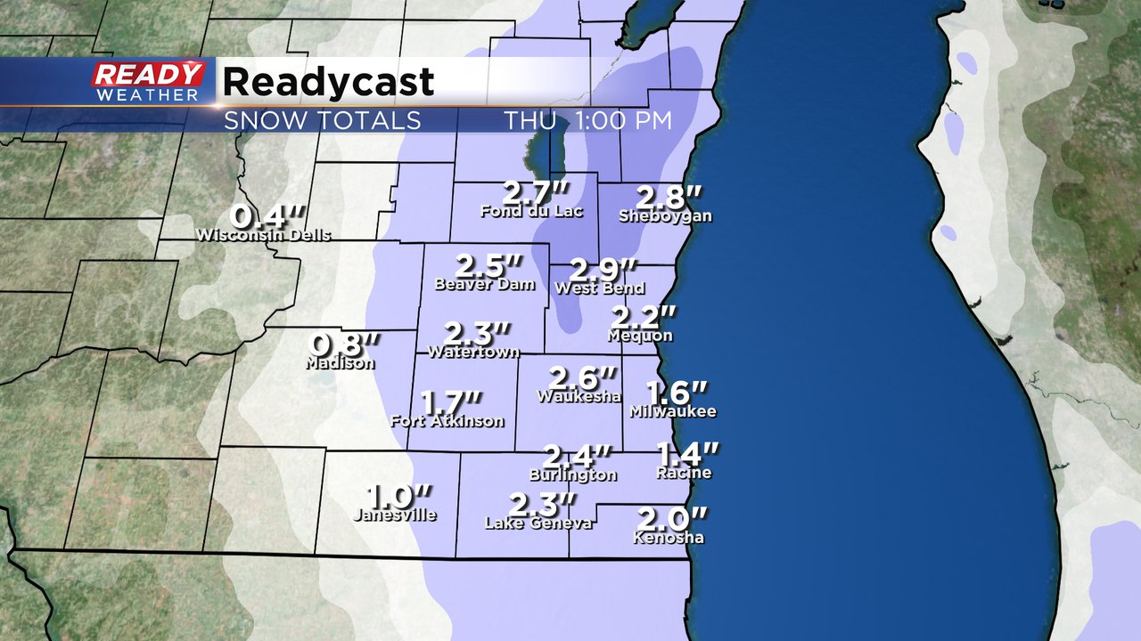
Bands of heavier snow really boosted snow totals in a few locations in southeast Wisconsin. Here are the final snow totals for this event,
Showers and drizzle will taper off later this evening.
---------------------------------------------------
Updated: 11:30 a.m. Nov. 21, 2024
Here's the latest snowfall report:
Temperatures cooled back quickly to provide overachieving snow totals from our first winter storm of the season! And now the snow is winding down for northern spots. But the wet weather isn't over. You can expect the snow to transition to rain from north to south during the noon hour.Updated: 9:28 a.m. Nov. 21, 2024
Snow is still falling for all of southeast Wisconsin. A break from the heavy snow in the Waukesha/Milwaukee metro area has allowed road conditions to briefly improve, but another round of moderate to heavy and steady snow is moving in from the north.
Here's a look at the radar that will update with time:
The first round of snow totals is currently in with most of southeast Wisconsin seeing 1-4" of snowfall but these totals will go up as more accumulating snow is expected. Timing for the storm has not changed with most of southeast Wisconsin switching to rain by Noon and rain showers continuing this afternoon and evening. Some snow will melt with the afternoon rain and high temps around 40.
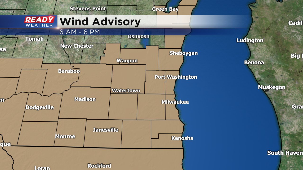
The wind is still expected to stay strong with wind gusts over 40 mph for part of the day. A wind advisory is now in effect for all of southeast Wisconsin through 6 PM.
The strong wind will keep feels like temperatures down in the chilly department with wind chills staying in the 20s to around 30 through the afternoon as high temperatures reach the low 40s.
Download the CBS 58 Ready Weather app to track the switch from snow to rain.
------
Updated: 7:05 a.m. Nov. 21, 2024
The steady, heavy snow is now approaching the Milwaukee/Waukesha metro area after dumping some accumulating snow already in northern counties. The heavy areas of snow, shown in deep blue, are dropping 1" to 2" of snow per hour which is enough to overcome any warm ground or roads.
In addition to the snow, it is chilly! With wind gusts over 30 mph at times Thursday morning, wind chills are reaching down into the teens this morning. Wind chills will warm into the 20s to around 30 this afternoon as highs reach around 40.
Here's a look at current wind chills:
Even without the heavy snow reaching Milwaukee, the number of crashes on the roads has jumped to about a dozen every 30 minutes. Take it slow!
You can see the latest winter road conditions courtesy of the DOT here:
By the time the snow is done, most of southeast Wisconsin will see 1-3" of wet, slushy snow with the majority of accumulation on grass, cars, patio furniture, etc. The rest of the forecast for Thursday and the details on the winter weather advisory and wind advisory outlined below remains the same.
------
Posted: 5:04 a.m. Nov. 21, 2024
The first measurable snow of the season is just about here! A winter weather advisory starts at 6 AM Thursday and goes until Noon. This will be a brief time period of snow, but moderate to heavy snow is expected during this time causing difficult travel right during the heart of the morning commute.
In addition to a winter weather advisory, a wind advisory has been newly issued from 6 AM Thursday to 6 PM. The strong wind gusts could lead to blowing snow but with the heavy, wet, slushy nature of the snow it won't cause any blizzard conditions. The wind will also push wind chills into the teens at times on Thursday so make sure to bundle up!
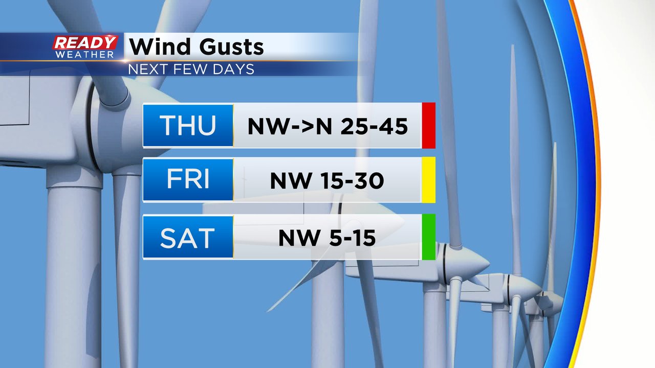
Wind gusts on Thursday are expected to peak around 45 mph! The wind will stay strong with gusts to 30 mph then we finally get a lighter wind on Saturday.
As of 5 AM, we've had persistent flurries and some light snow showers since Wednesday afternoon but the area of heavy, steady snow is still just to our north. That heavy snow is expected to quickly move south arriving in the Milwaukee/Waukesha Metro area around 6 AM and by 7 AM all of southeast Wisconsin should have the steady snow.
By noon most of southeast Wisconsin has seen the end of the accumulating snow with the snow mixing and switching to snow around the midday hours then all rain showers during the afternoon and evening. The accumulating snow in the morning should reach a range of 1-3" with highest totals in the Kettle Moraine where some areas could get over 3" and lowest totals near the lakefront.
Download the CBS 58 Ready Weather app to track the snow and wind.


