Tornado Watch for Racine, Kenosha, and Walworth counties has been canceled.


Updated: February 27th, 2024 9:00 PM
The NWS has canceled the tornado watch. The bulk of the severe weather has stayed south across northern Illinois. Scattered storms will move out by 11 pm with a transition to snow overnight.

Many areas will pickup around 0.5" to 1" of snow. Some of our northwestern areas could get over 1".
Slick roads for the morning commute are possible as temperatures drop into the 20s! Snow should move out by 7 am.
______________________________________________________________________________________________________________

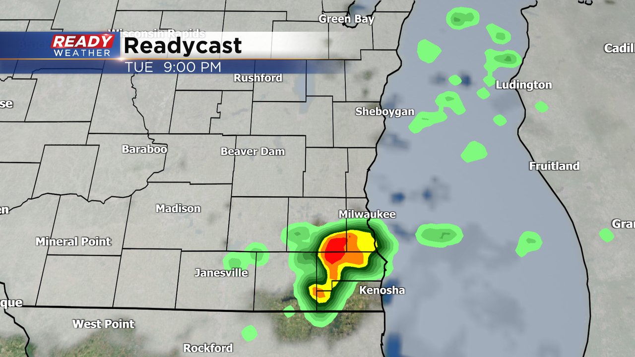
Updated: February 27th, 2024 8:15 PM
The front is starting to light up across southeastern Wisconsin. This line could produce some hail and gusty winds. There's a lot of lightning and thunder, it's crazy that we are talking storms in February.
The tornado watch remains in effect until 10 pm.
______________________________________________________________________________________________________________
Updated: February 27th, 2024 7:30 PM

It's been a busy night across northern Illinois with multiple tornado reports across the western suburbs of Chicago. While that mess should miss us, we are watching some additional activity near Rockford.
If those storms can get going, they have a chance to clip our tornado watch counties along the border.

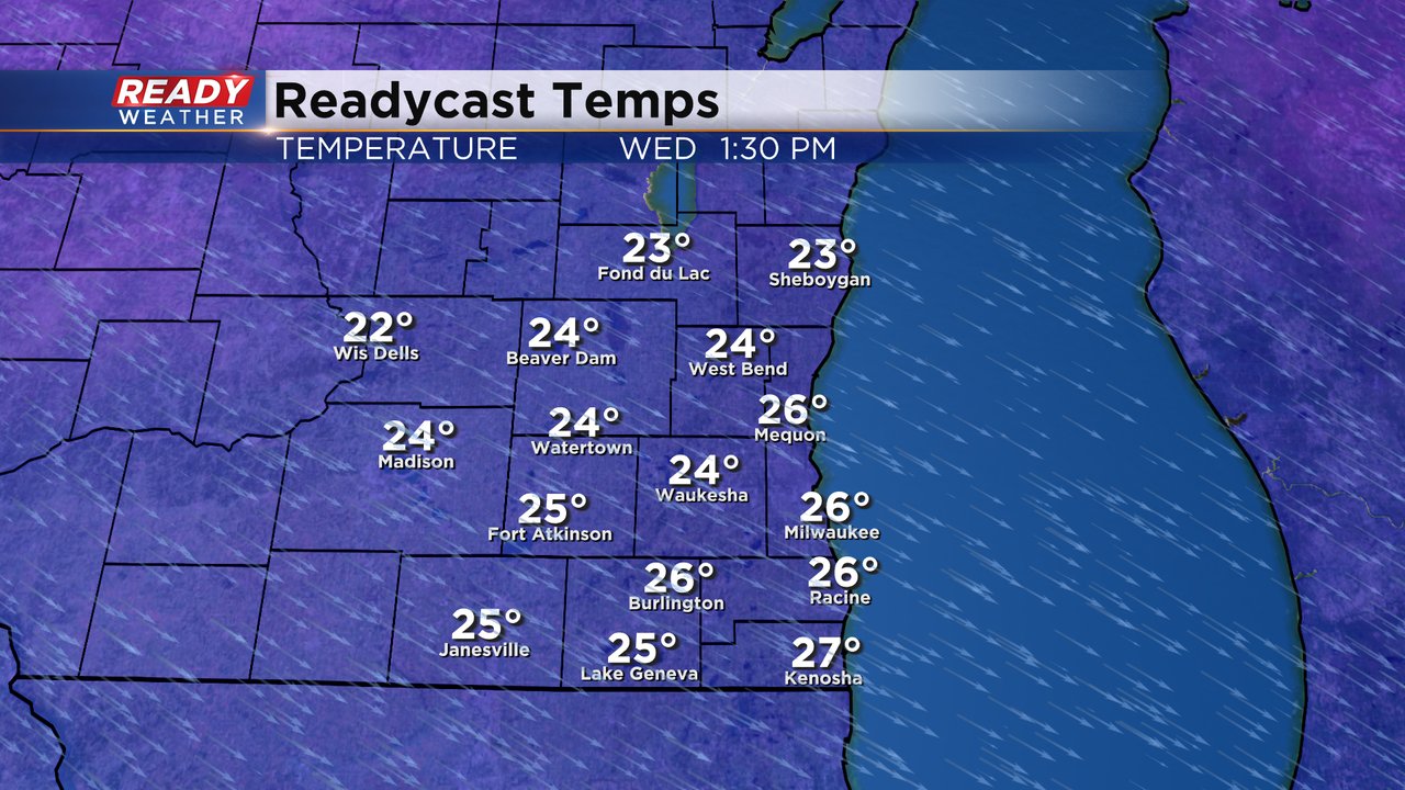
The arctic front is moving across the state. We expect temperatures to fall into the 20s by morning with light snow. Any light snow could create slick spots on the roads for the commute.
_________________________________________________________________________________________________________

Updated: February 27th, 2024 5:30 PM
A tornado watch has been issued for Racine, Kenosha, and Walworth counties until 10 pm. Storms have blown up across northern Illinois over the last hour. That atmosphere is primed for explosive storm development to our south.

As those storms approach from the south, they should hold their strength close to the IL/WI border. Storms that are near the border could rotate and produce isolated tornadoes.
In addition to the tornado threat, damaging winds and hail are possible.
______________________________________________________________________________________________________________

Updated: February 27th, 2024 3:30 PM
The SPC has issued a mesoscale discussion for northern Illinois. There will likely be a tornado watch just to our south. We expect storms to develop over the next several hours across Illinois, and those storms will move in our direction later this evening.
Storms near the IL/WI border will need to be watched for rotation. The greatest tornado threat will be across Walworth and Kenosha counties. Storms timing between 6pm and 10 pm seems realistic.
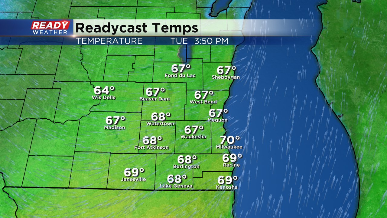
Milwaukee has now set a new all-time record high for February. As of now the temperature is 73 breaking the old record of 71.

Look at the big drop in temperature expected overnight! Light snow will also accompany the cold, creating slick spots for the morning commute.
______________________________________________________________________________________________________________
Updated: February 27th, 2024 11:40am:
It's a blink and you'll miss it kind of weather set up the next couple days. Here's the nuts and bolts of what you need to know:
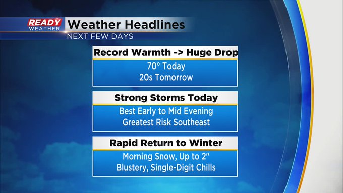

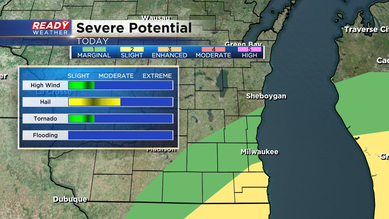
The Storm Prediction Center has placed Kenosha, Racine, Walworth, southern Milwaukee, and SE Waukesha counties under a level 3 of 5, Enhanced Risk, for severe storms this evening.

Very large hail, possibly 2" in diameter or greater, is possible with storms this evening. An isolated tornado also can't be ruled out. Park your car under shelter this evening if you can. Main window of concern is between 6-10pm.
----------------------------------------------------
Updated: 9:05 a.m. Feb. 27, 2024
The rising temperatures are our first focus on this crazy 24 hours of weather. Then the focus will shift to the chance for strong storms this evening, a big temp drop tonight and light snow on the way for tomorrow morning. The temperature, storm and snow forecast outline below remains on track.
Here's an image with current temperatures that will update with time throughout the day:

We are chasing two records on this third to last day of February. The first is the record high which is currently 65* set in 1976. That record is likely shattered as highs reach the upper 60s to around 70. We are also tracking the record warmest low for Tuesday. The current record is 38* set in 2000. We will have to wait until midnight to see how fast the temp drops with the cold front but the current forecast temp at midnight of 42* would be warm enough to break that record as well.
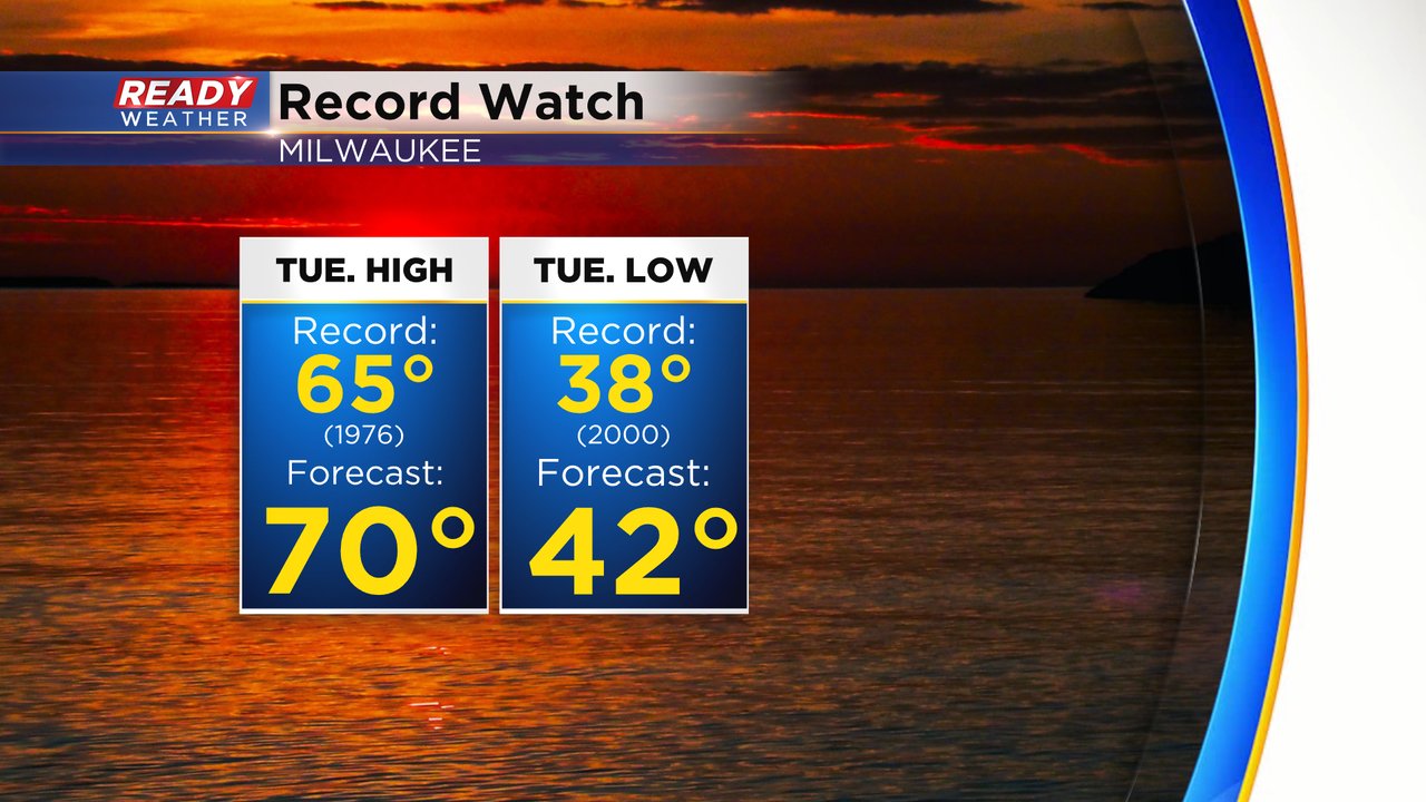
Not only are we tracking daily high and warm low records for today, but also the warmest February temperature on record. That record was set a few years ago in 2017 of 71* and is the only time the month of February has recorded a 70 degree day.

Download the CBS 58 Ready Weather app to track the record chase and get alerts if any warnings are issued with storms Tuesday evening.
------
Posted: 5:10 a.m. Feb. 27, 2024
Get ready for a wild next 24 hours of weather! One of the biggest temperature swings on record will roll into our area as a breezy southwest wind Tuesday warms temps up then a monster cold front quickly cools us down. Let's start with the temps. Tuesday morning is already super mild in the 40s and low 50s. We warm up into the upper 60s to around 70 by the afternoon. The current record high in Milwaukee for Tuesday, February 27, is 65* and we likely shatter that record.
But then the cold front rolls in and drops the temps into the 50s then 40s then 30s in some areas by midnight. By Wednesday morning some upper teens to around 20 will be the wake up temps. Highs don't warm much from there with afternoon highs Wednesday in the middle to upper 20s.
The strong cold front Tuesday evening will also bring with it the chance for strong to borderline severe storms. The best ingredients for these storms will be south of I-94 and especially in our southeast counties. The best timing for any storms will be from 5 PM to Midnight.
All or parts of Milwaukee, Racine, Kenosha and Walworth Counties are currently under a Level 2 of 5 Slight Risk for Severe Weather. Large hail would be the main threat with any storms but strong wind and a brief tornado are not out of the question.
As the cold front drops the temps in the evening and showers and storms will switch to snow a little after midnight. Those snow showers will stay with us through the early morning hours of Wednesday and leave during the morning commute.
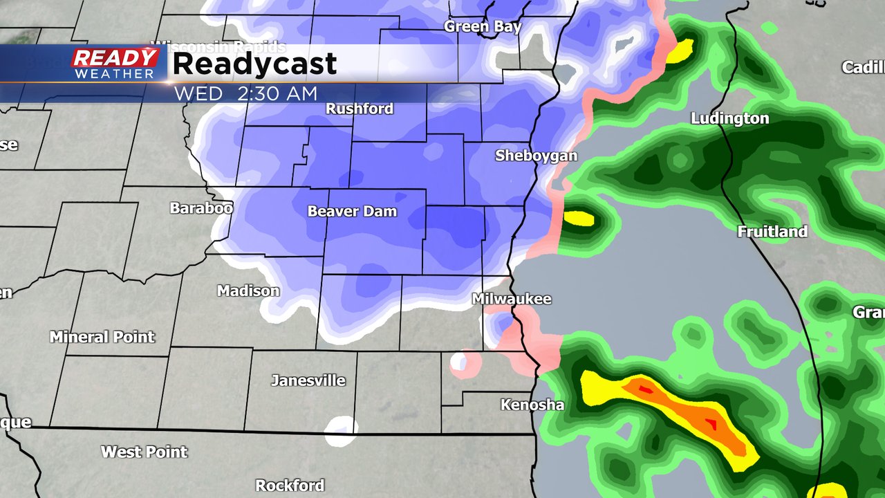
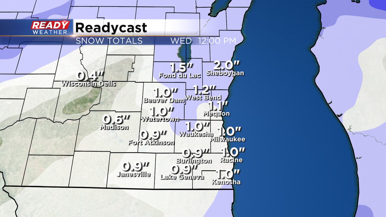
Highest snow totals will likely stay in our northern counties where 1-2" are possible but nearly everyone is expecting snow with around 1" or a little less in southern counties. We could see some sunshine Wednesday afternoon which should melt a bit of that snow. More will melt Thursday with highs getting back to 40* with some sun.
Download the CBS 58 Ready Weather app to track the strong storms switching to snow and whiplash temps.