Overnight Update: Additional accumulation is possible overnight for the morning commute


Updated 10:30 PM Nov 15, 2022
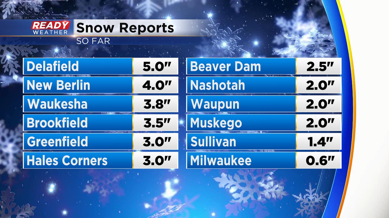
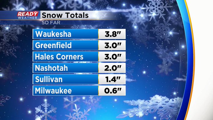
Here's an updated look at snow reports across the area. Some isolated spots have been between 4" and 5" of wet snow.
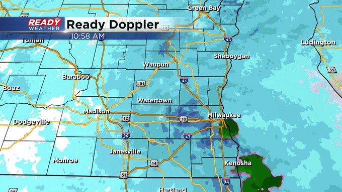
Still seeing some decent bands of snow show up just west of the lake. Lower visibility correlates with the heavier snow.
Tonight, we expect areas away from the lake to drop into the upper 20s to around 30, so a refreeze is expected and will create more slick spots. Side roads and sidewalks will be impacted.
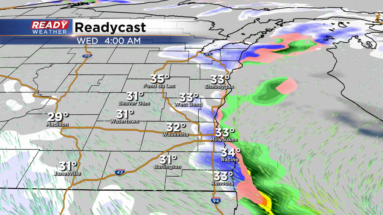
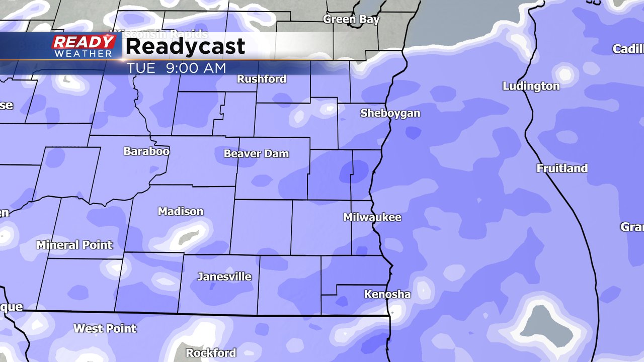
Another band of snow is forecast to develop after midnight and head south near the lakefront. That could produce another 1" to 2" of snow through Wednesday morning. The majority of the snow will be done after the commute on Wednesday. Areas right along the lake will toggle between rain and snow.
Some light snow is possible Wednesday afternoon and evening; however, we don't expect more accumulation.
______________________________________________________________________________________________________________
Updated 1:45pm Nov 15, 2022
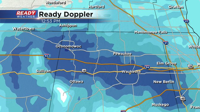
Heavier snow bands have continued to set up in the same locations, especially through the I-94 corridor in Waukesha County. It's possible we could get snow rates at a half inch to inch per hour through the rest of the afternoon and throughout the evening.
Updated 11:00am Nov 15, 2022
Snow is in progress widespread at this time.
Updated: 10:05 a.m. Nov. 15, 2022
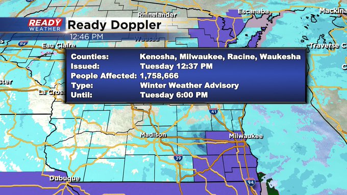
Moderate snow is still coming down in many locations. Temperatures are hovering in the low to middle 30s. Areas that are around or below freezing are the ones that are dealing with snow covered roads. Visibility is a good indicator of who is seeing the heaviest snow and as of the late morning hours it's these communities with visibility under an inch. Moderate bands of snow are expected through the rest of the day.

------
Updated: 8:04 a.m. Nov. 15, 2022
A good steady snow is now falling across all of southeast Wisconsin right during the heart of the morning commute. The road conditions really depend on the temps. Where temperatures are above-freezing to the east and in lakeside communities roads are being reported as just wet and in pretty good shape but inland counties are dealing with slippery stretches with temperatures hanging out around or just below freezing.

------
Updated: 6:03 a.m. Nov. 15, 2022
All of southeast Wisconsin is currently seeing some light snow. Most of it is some fine snowflakes and flurries so far but the snow will begin to pick up during the morning commute with some already seeing an inch of slush by mid-morning Tuesday.
The snowfall on Tuesday is coming as Milwaukee is running a touch behind on snow for the season. The official average snowfall through the middle of November is 0.8" and so far we have only seen a trace of snow.

We could potentially make up that whole deficit in one day with snow totals Tuesday expected from 1-3".
------
Posted: 5:05 a.m. Nov. 15, 2022
As of 5 AM Tuesday morning light snow flurries and flakes have started falling in southeast Wisconsin. The snow will continue to intensify over the next few hours with accumulating snow expected during the morning commute. Here's a look at the latest radar that will update with time:
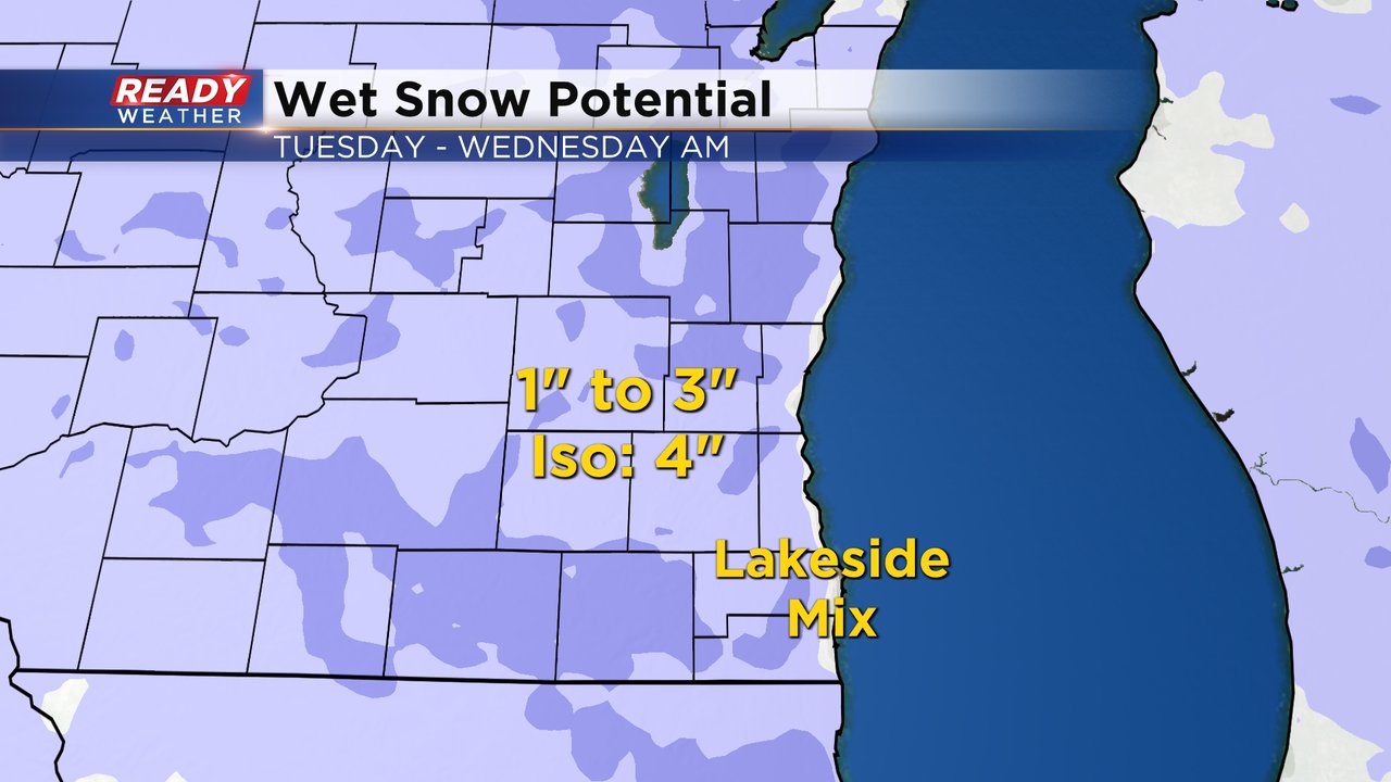
There are no major changes to our snowfall map for this storm. Most of southeast Wisconsin will see 1-3" of snow. Some isolated inland locations could hit 4" and lakeside areas may see an off and on rain/snow mix that could prevent some lakeside communities from getting to 1".
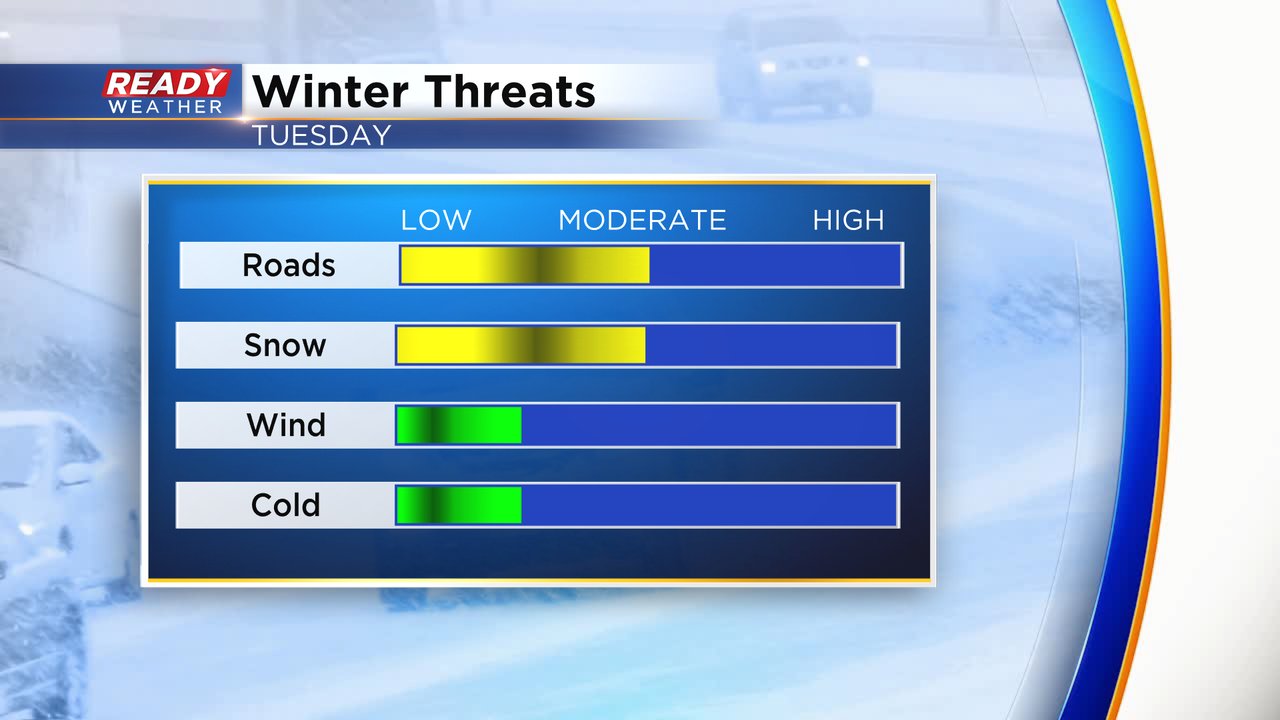
Threats from the storm remain the same as well. No cold air or wind are expected. The snow will be light to moderate at times which will reduce visibility. There could be some bursts of heavy snow. Some sideroads and untreated sidewalks could become snow covered but most main roads and freeways will only see wet and slushy roads.
Download the CBS 58 Ready Weather app to track the snow.