8:00 PM Update: Severe weather threat is over


Updated: 8:30 p.m. May 31, 2022
While scattered showers and some storms have developed across the area, the severe threat is over. Thankfully, the ingredients didn't come together to produce strong to severe storms ahead of the cold front. Afternoon cloud cover limited the instability.
The front will move through by midnight and quiet weather will continue overnight.
_____________________________________________________________________________________________________________
Updated: 7:30 p.m. May 31, 2022

Scattered showers and a few storms have popped this evening. As of now, all of them remain well below severe limits. Storms are having a tough time breaking through ahead of the front.
If any storms can get going, the timing for any severe weather has shifted a bit later with the best chance now looking like 8 pm until Midnight.
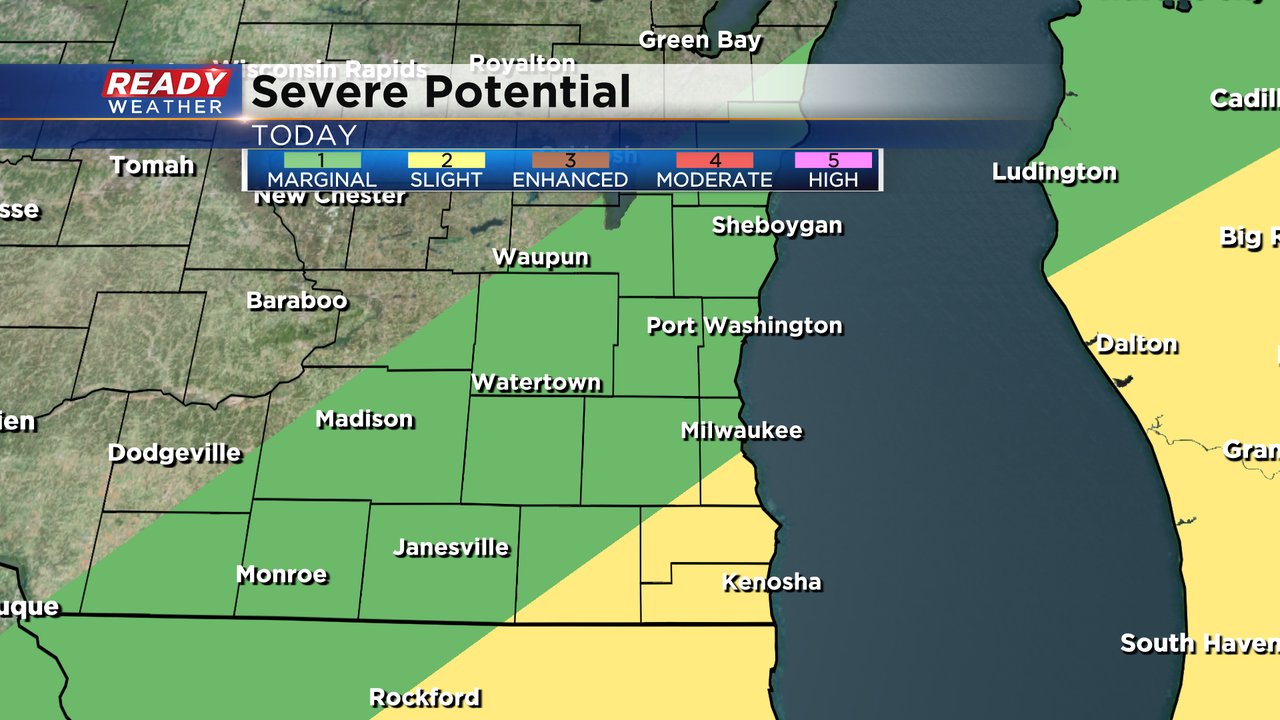
All of Racine and Kenosha Counties and parts of Milwaukee and Walworth Counties are under the Level 2 Slight risk for severe weather with the rest of southeast Wisconsin under a Level 1 Marginal Risk. Strong wind and some hail remain the main threats with a very low chance at a tornado.
------
Updated: 9:54 a.m. May 31, 2022
We're watching an area of rain down in southern Iowa that is moving northeast. There's a couple of showers along this front that could reach southeast Wisconsin for an isolated shower chance this morning. The better chance for stronger storms remains this afternoon and evening.

The latest severe risk from the Storm Prediction Center takes the risks a little farther southeast. Only Racine and Kenosha and parts of Milwaukee and Walworth Counties are now included in the Level 2 Slight Risk for severe weather. Most of the rest of southeast Wisconsin is under the Level 1 Marginal Risk.
------
Posted: 7:48 a.m. May 31, 2022
Memorial Day was tied for the warmest day of the year so far in Milwaukee. We got close to 90* in some inland communities but fell just short. Tuesday will be another warm day with high temperatures well into the middle 80s. The dew points will be a little higher which will keep us more humid than the last few days. A cold front arrives Tuesday afternoon/evening that drops the temperatures and dew points the rest of the week.

With all the energy that comes with the heat and humidity we will have plenty of fuel for some thunderstorms to form along the cold front. The best timing for the front looks to be from 4-8 PM.

Some of the thunderstorms this evening could be strong to severe. Our southeast counties are under the Level 2 Slight Risk for severe weather. Damaging wind and large hail are the main threats with any storms that do develop although an isolated tornado can't be ruled out.

Download the CBS 58 Ready Weather app to track the storms.