The severe thunderstorm watch has been dropped!


8:30 PM
The severe thunderstorm watch has been dropped for the area. The storms that prompted the warnings have weakened. Scattered rain and some storms are possible overnight, but there won't be a severe weather risk to the area.
_____________________________________________________________________________________________________________
6:20 pm Update
We have newly issued Severe Thunderstorm Warnings for Dodge and Fond du Lac counties. Take a look: This line is cooking east at 50 mph. The main hazard is wind gusts to 60 mph. Downstream warning are quite possible with this line. Keep checking back here for updates as well as on air. The warning runs until 6:30pm.

A severe thunderstorm watch has been issued for our northern counties until 9 pm. Strong to severe storms have erupted across central Wisconsin and will move into our area this evening.

Hail and gusty winds are the primary threats. Storms to the west will arrive between 6:30 pm and 10 pm. The metro will likely not see storms until after 8 pm. We will watch the trends.
______________________________________________________________________________________________________________
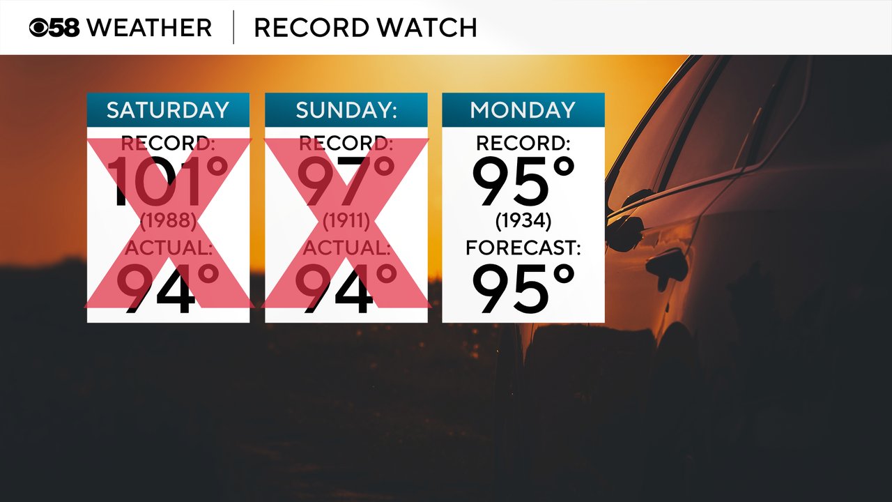
Hot has been the word for the first weekend of summer. High temperatures both Saturday and Sunday topped out at 94 degrees but feel like temps climbed well over 100 with some getting close to 110. Both Saturday and Sunday feel short of the respective records but Monday has most attainable record at a "cooler" 95 degrees set back in 1934. 95 is also the forecast today so we could definitely tie or break that record.
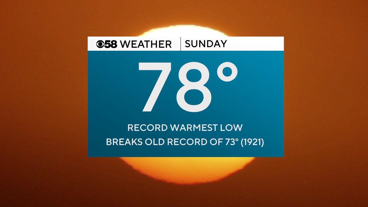
Even though we didn't break any record highs over the weekend we did break one record - the warmest low for Sunday. The low on Sunday only dropped to 78 degrees which is the warmest low ever recorded for the date and shatters the old record of 73 set back over 100 years ago in 1921.
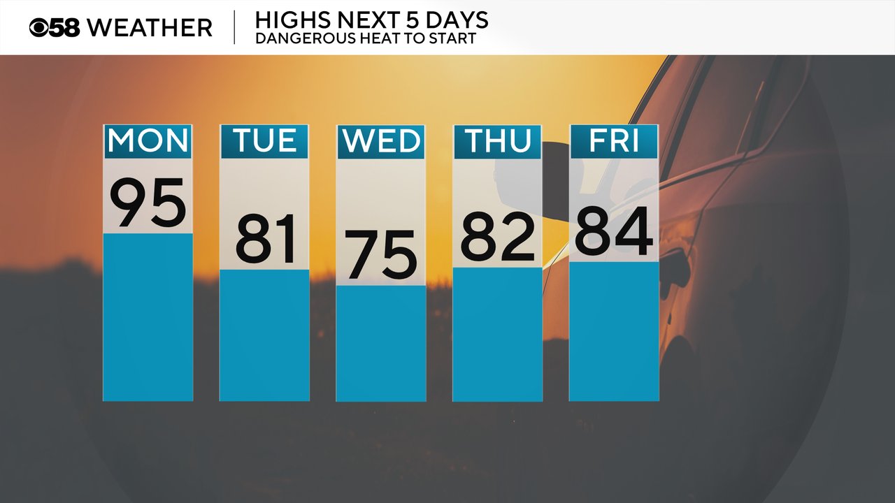
After Monday's continued heat with highs in the 90s we get a cold front Monday night. That brings some relief to Tuesday with highs around 80 but Wednesday will be the better day, especially lakeside, with a northeast wind dropping temps into the 70s. We do warm back up into the middle to upper 80s for the end of the week.
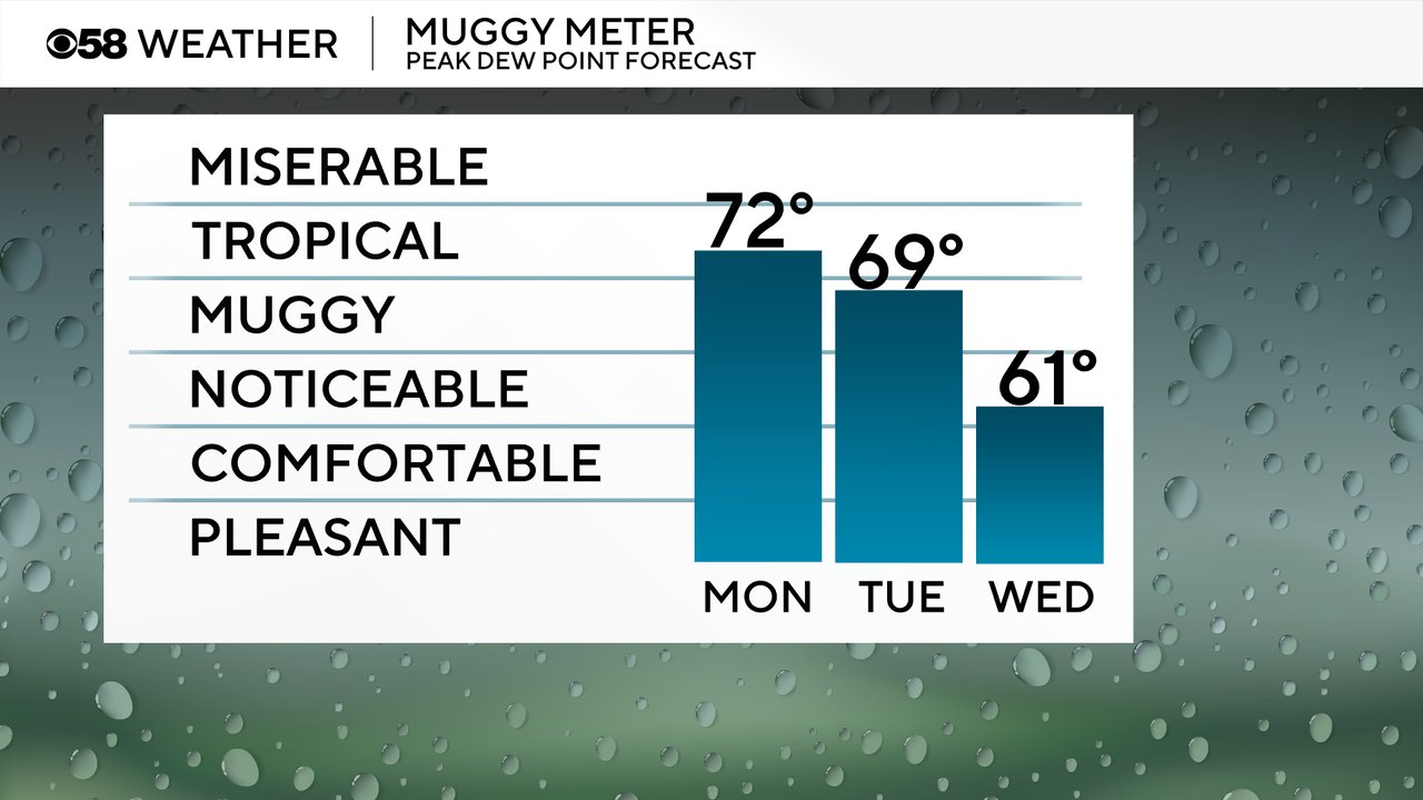
Humidity levels stay very high Monday with tropical-level dew points in the low 70s. Even though the temperatures drop a bit Tuesday, it's still going to be pretty humid, especially in the morning. The bigger humidity relief arrives Wednesday with barely noticeable dew points around 60.
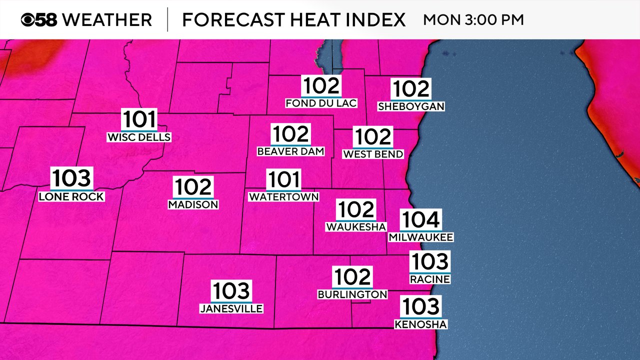
All of the heat and humidity for Monday will once again push the feels like temperatures will into the 100s. Forecast heat index values could get as high as 100 degrees in some locations.
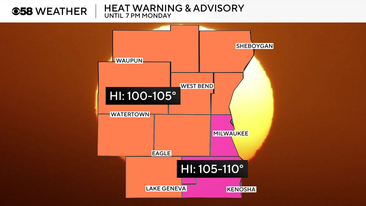
There have been no changes to our heat headlines with a Heat Advisory (in orange) still in place for most of the area and an Extreme Heat Warning (in pink) in place for Milwaukee, Racine and Kenosha counties. Both the advisory and warning go until 7 PM Monday.
The cold front that brings the relief from the heat will also bring in a chance for storms. Locally, that chance doesn't really start until after 6 PM Monday with our northern and some western counties seeing the best chance for storms this evening. The Milwaukee/Waukesha metro may see some storms tonight but some far southeast counties like Racine/Kenosha might not get the storms as the front stalls across our area.

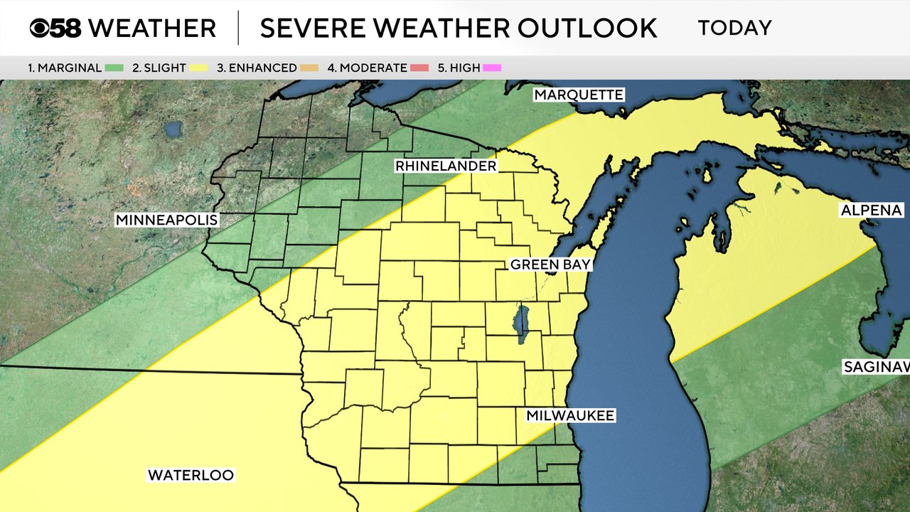
Any storms that do reach southeast Wisconsin Monday evening with the cold front could be on the strong to severe side with most of Central Wisconsin under a Level 2 Slight Risk and most of the rest of the state under a Level 1 Marginal Risk. Strong wind and an isolated tornado will be the main threats along with some small hail.
Download the CBS 58 Weather app to see how hot it's going to be where you live and track the storms as they develop to our west this afternoon and evening.