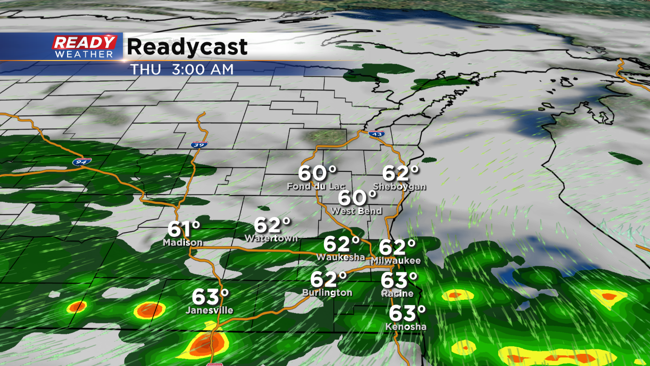
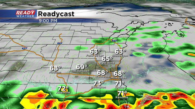
8 PM Update: Storms will slowly push south after midnight.


The severe thunderstorm watch has been dropped for Washington, Dodge, and Ozaukee county.
Heavy training thunderstorms continue to generate along and north of a surface boundary this evening. Many areas have already picked up 1" to 2". Localized flooding is possible.
Model guidance suggests the showers and storms will move south after midnight into Illinois. The boundary will lift back north later tonight with another chance for showers for the Thursday morning commute.
______________________________________________________________________________________________________________
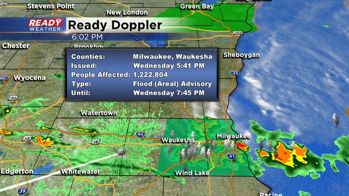
6:00 pm Update...Wednesday, September 11
An Urban and Small Stream Flood Advisory is in place for much of Milwaukee and Waukesha Counties until 7:45 pm. Some places have received over a few inches in a short amount of time. Please watch for water-covered roads and don't drive on them. Remember, turn around, don't drown.
____________________________________________________________________________________________________________
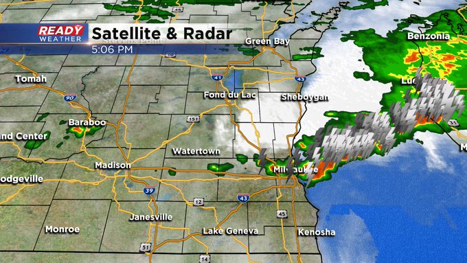
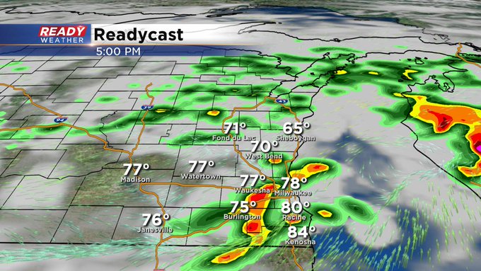
5:00 pm Update...Wednesday, September 11
The metro got pounded with rain and storms at the height of the evening rush. Luckily, no warnings to mention (as of now). But we're still watching the prospects of stronger storm development south of I-94 over the next few hours.
Once the storms die down tonight, we run the risk for a few more bouts on Thursday, especially at night. Of course, the entire CBS58 Ready Weather team will keep you updated.
______________________________________________________________________________________________________________
4:00 pm Update...Wednesday, September 11
So far this afternoon, most of the action has been north of I-94. Our one reliable computer model says a lot of the action will start drifting south as we get into the evening. A few could be on the stronger side with gusty winds, large hail, frequent lightning, and very heavy rain. Stay tuned to CBS58 for the rest of the day into tonight for storm updates.
__________________________________________________________________________________________________________
3:21 pm Update...Wednesday, September 11
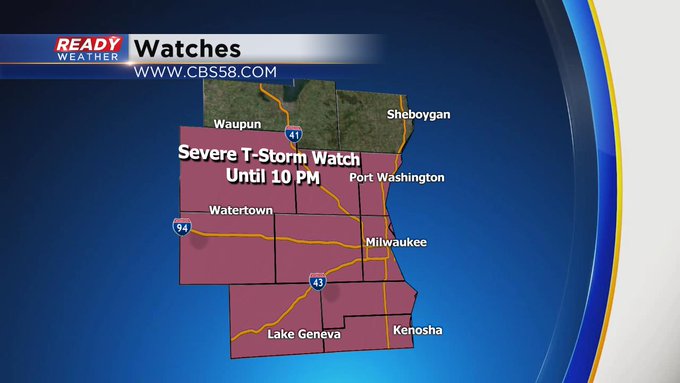
The Severe Thunderstorm Warning for Sheboygan County also has been canceled. Keep in mind the only active weather watch we have is a Severe Thunderstorm Watch until 10 pm for most of the viewing area except Fond du Lac and Sheboygan Counties.
______________________________________________________________________________________________________________
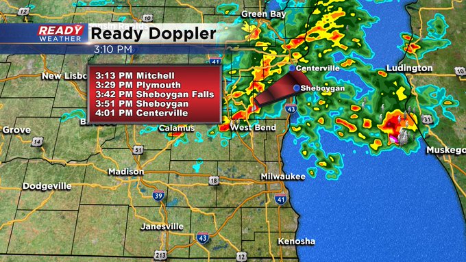
3:12 pm Update...Wednesday, September 11
The Severe Thunderstorm Warning for Fond du Lac County has been canceled. But the warning for Sheboygan County continues until 3:30 pm. Plymouth and Sheboygan both could see severe weather in the next 30-45 minutes.
______________________________________________________________________________________________________________
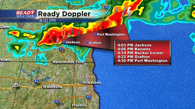
3:00 pm Update...Wednesday, September 11
A new Severe Thunderstorm warning kicks off the hour. It's for southeast Fond du Lac and southwest Sheboygan Counties until 3:30 pm. These storms are working to the northeast at 35 mph. Damaging wind, large hail, and heavy rain are all possible. An isolated tornado can't be ruled out either. Look for more storms to develop over the next three to four hours.

CBS 58 Ready Weather Chief Meteorologist Drew Burgoyne and the entire weather team are watching the developing weather situation and will keep you updated.
____________________________________________________________________________________________________________
2:00 pm Update...Wednesday, September 11
Still waiting on the storms to come our way. We're already seeing some action well north of I-94. Nothing severe as of yet. This one computer model has the activity arriving across the metro after 5 pm and then it darts off to the south, straddling the WI/IL border by mid-evening. Gusty wind, damaging hail, frequent lightning, and heavy rain are all possible. The CBS58 Ready Weather team is on top of the situation for you this afternoon and will keep you updated.
_
1:40 pm Update...Wednesday, September 11
A Severe Thunderstorm Watch is now issued until 10pm for most of southeast Wisconsin. Fond du Lac & Sheboygan Counties aren't included in the watch. Large hail, damaging wind, and frequent lightning are all possible in addition to heavy rain. Stay tuned to CBS58 and cbs58.com for further updates.
________________________________________________________________________________________________________
1 pm Update...Wednesday, September 11
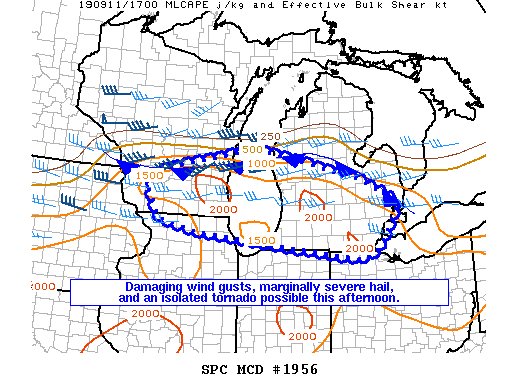
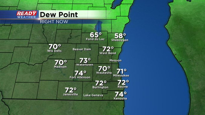
It's hurry up and wait for the strong to severe weather expected this afternoon into this evening. In fact the Storm Prediction Center says there's a good chance some kind of storm watch may be issued within the next hour or so. We certainly have ample moisture/humidity to work with in the atmosphere. The dew point numbers are well in the 70s, so it feels rather tropical. You involve a "trigger" mechanism and then you get your explosion of storms. This is what we could see after 3 or 4 pm across much of southeast Wisconsin.
Stay tuned to CBS58 and cbs58.com for all the weather updates coming this afternoon. And make sure to download the CBS58 Ready Weather app. It's free for Android & Apple users.
___________________________________________________________________________________________________________
After a soaking Tuesday, more rounds of heavy rain and storms will be possible the next two days. Some saw a few light showers and thunderstorms roll through Wednesday morning. A larger area of rain currently impacting Minnesota and Iowa into western Wisconsin is expected to move in around noon although may weaken by the time it arrives.
The third round of storms for Wednesday arrives in the evening and is expected to be the heaviest.

Strong to severe storms may be possible with any round of storms Wednesday, especially in the evening. Strong wind and hail are possible but the biggest threat is heavy rain.

A few showers or storms may be possible Thursday but once again the best chance for heavy rain moves in during the evening and overnight into Friday morning. By the time the rain exits on Friday some spots could pick up 1-3" with localized areas seeing more.

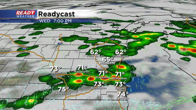
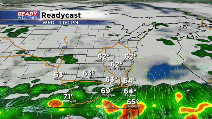
In addition to the rain on Wednesday, expect a pretty swift temperature drop this evening. Temperatures will go from the low to middle 80s during the afternoon to the 60s this evening. Make sure to grab the jacket or hoodie in addition to the umbrella if you have evening plans.
Download the CBS 58 Ready Weather App to see when the temp drop hits your house and so you can get alerts if watches or warnings are issued.