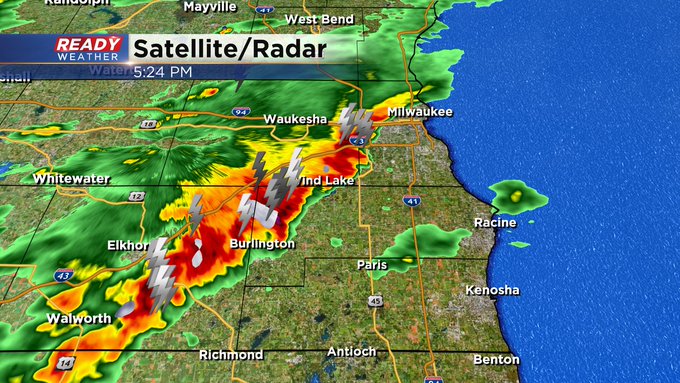
Evening Update: Strong storms remains possible, but the overall risk is low.


Thankfully, the storms have weakened across southeastern Wisconsin. The greatest ingredients for severe weather remain across northern Illinois. Most of the storms that moved through produced hail and gusty winds.
While an isolated strong to severe storm remains possible for Kenosha County, the threat will be over in an hour or so when the front moves through.
______________________________________________________________________________________________________________
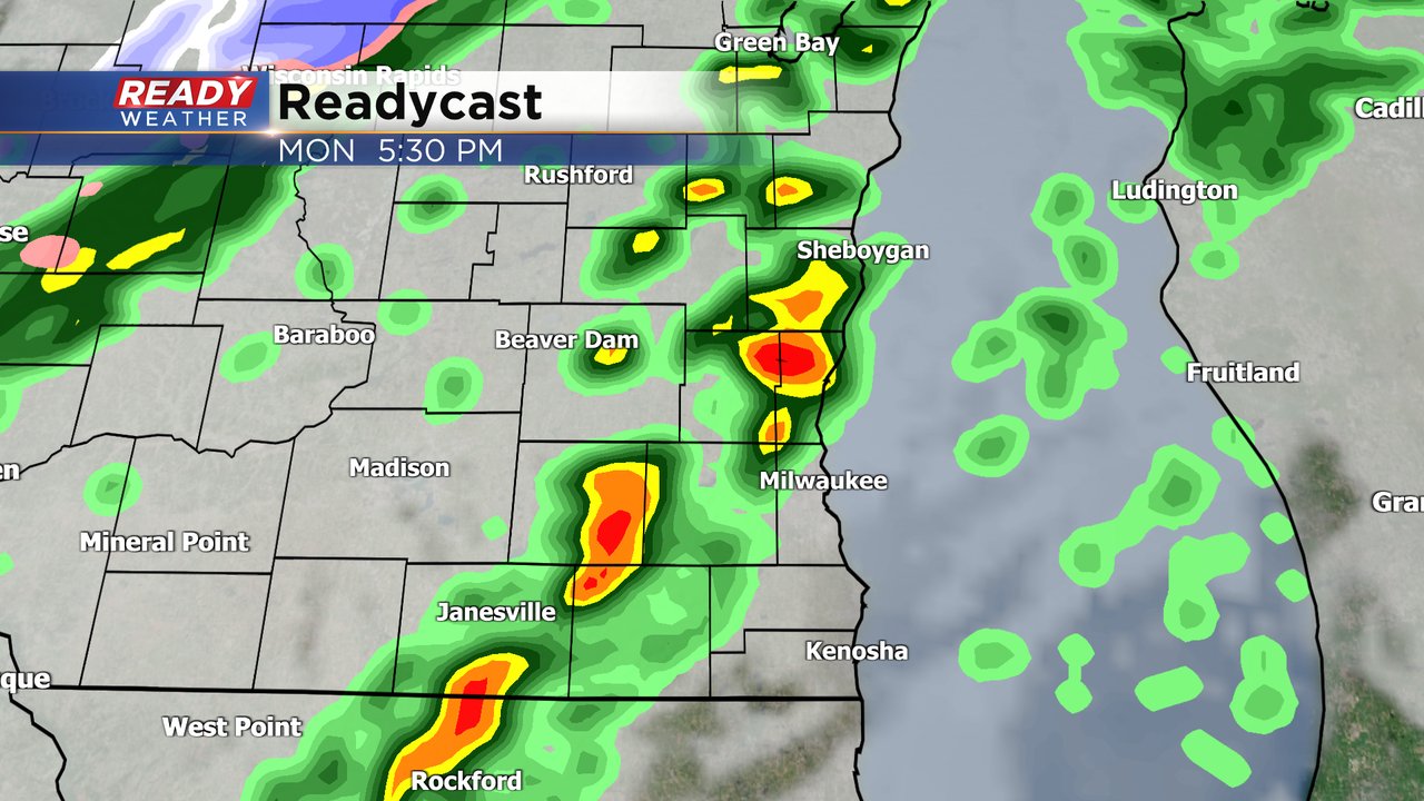
We no longer have any active warnings in place as of 5:30pm. That said, still some strong storms ongoing. Here's a look at Ready Doppler:
Here's the latest on alerts across the area:

4:00 PM Update:
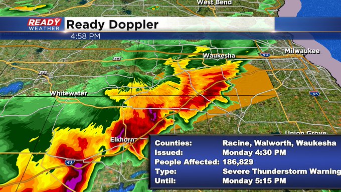
Severe thunderstorm warning continues for Walworth County until 4:30. This storm continues to rotate and needs to be watched closely. This storm has the history of producing many funnel clouds and large hail.
This storm is near the warm front, and that's where the shear is maximized.
________________________________________________________________________________________________

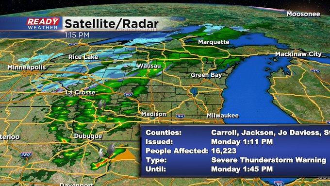
2:00 PM Update:
We are watching the border of IL/WI very closely this afternoon. A warm front is sitting very close to the border. Temperatures south of the front are in the 70s. North of the front temperatures are in the 40s and 50s.
Any storms that can get near or around the warm front could become strong to severe. All modes of severe weather are possible; however, it will be highly conditional.
________________________________________________________________________________________________
Morning sunshine gives way to more clouds this afternoon, along with a lake breeze. Those two factors may limit how strong storms get for southeast Wisconsin. That said, we have our first severe thunderstorm warning with a cell moving out of Iowa and into northern Illinois. Take a look:

After a mostly sunny weekend the storm chance is going to ramp up throughout the day on Monday. Monday morning started off with a great sunrise but by the lunchtime the clouds will increase and the shower and storm chance will roll back in during the afternoon and evening. The best timing for rain will run from 3 PM Monday through Tuesday morning.
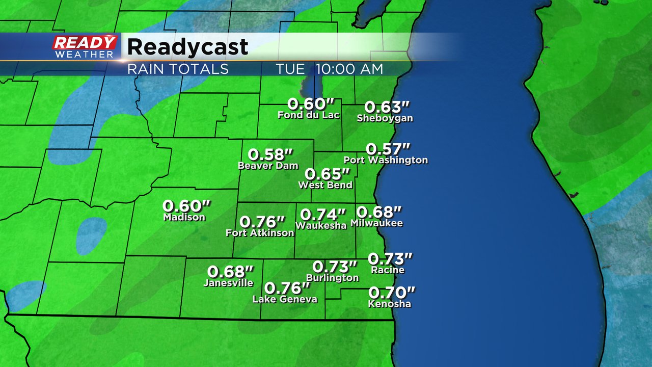
With scattered showers and storms likely throughout most of the evening and overnight hours, our rain totals will be fairly soaking. Over a half inch of rainfall will be expected for most of southeast Wisconsin with most up to 0.75" but isolated locations could see a full inch of rain in thunderstorms.
Any storms that form could be on the stronger or even borderline severe side with some hail and gusty wind the main threats. Some of our counties, shaded in green in the image below, are under the Level 1 Marginal Risk.

The threat for strong storms will also be dependent on how far north a warm front gets on Monday. Southern counties that see the warm front pass through could get into the 60s to around 70 for highs. Northern counties will stay cooler with highs likely staying in the 50s and maybe even falling short of 50. Milwaukee most likely ends up in the upper 50s to around 60 for afternoon highs Monday.

Download the CBS 58 Ready Weather app to track the storms with the interactive radar.