Evening Update: Snow is weakening across the area. Roads remain very slippery.


Updated: 9:30 pm Feb 12, 2025
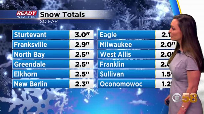
Here are some of the updated snowfall totals. As expected, areas near the lake received the highest snowfall. Milwaukee will be over 7" when the snow wraps up later tonight.

The snow will continue to weaken through Midnight. No snow is expected for the morning commute, but some blowing and drifting is possible. Secondary roads will remain slick for Thursday morning.
______________________________________________________________________________________________________________
Updated: 7:00 pm Feb. 12, 2025

A moderate band of snow continues to cut across the metro tonight. Milwaukee is already over 5" out of this evening. Another inch or two is possible before the snow wraps up after 10 pm.
Roads remain snow covered and slick across the area.
_____________________________________________________________________________________________________________
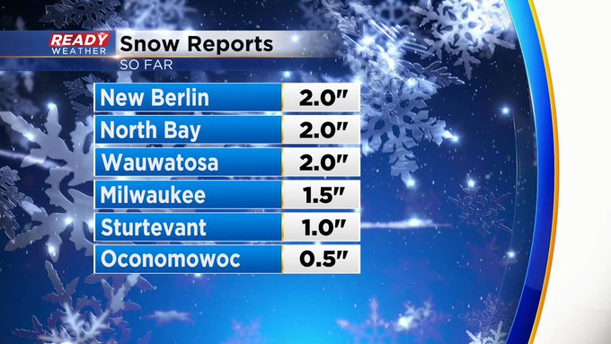
Here are the latest totals!

Heavy snow is coming through this afternoon into the evening. Lower visibility with heavier snow will remain a problem.

Another 1" to 3" is expected through this evening. Snow will come to an end around midnight. Even though the snow will be done, slick roads will continue throughout the morning commute. Side roads and secondary roads will be most susceptible
______________________________________________________________________________________________________________
Updated: 1:50 p.m. Feb. 12, 2025
Snow continues on this Wednesday. Here's some totals coming in early this afternoon.
Updated: 11:35 a.m. Feb. 12, 2025
Snow is widespread and roads are slippery area wide. Here's the latest check of Ready Doppler:

Updated: 8:46 a.m. Feb. 12, 2025
Light snow has started falling for parts of southeast Wisconsin, especially south of I-94. That snow will continue to spread north and east throughout the rest of the morning. By the end of the morning hours most of southeast Wisconsin will see steady snow fall that will continue through the afternoon and evening.
Here's a radar image that will update with time:

The most impactful part of the storm will be from lunchtime through the late evening hours when most of the accumulation will happen and breezy winds will cause some blowing snow. Roads will likely be snow covered from the lunch hour through late this evening resulting in a very slow evening commute.

The rest of the forecast outlined below, including snow totals, remains on track.
------
Posted: 5:19 a.m. Feb. 12, 2025
Snow is on the way! The morning commute and ride into work and school for those districts still in session Wednesday morning should be fine. By the late morning hours steady snow starts coming down and stays with us most of the afternoon and evening. 10 AM to 10 PM looks like the most likely time for accumulating snow with a few snow showers lingering through 2 AM early Thursday morning.

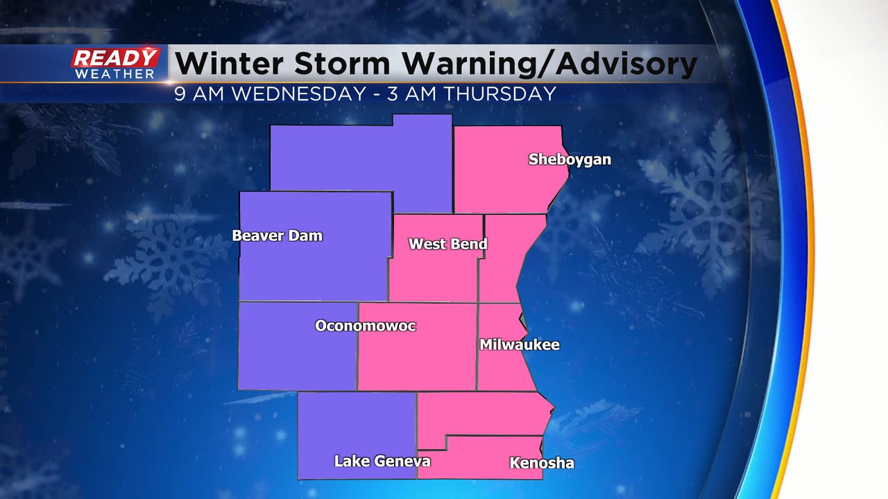
All of southeast Wisconsin is under either a Winter Weather Advisory in purple or a Winter Storm Warning in pink. The Advisory for our western counties starts at 9 AM. The warning starts at Noon. Both the Winter Weather Advisory and Winter Storm Warning are in effect until 3 AM Thursday.
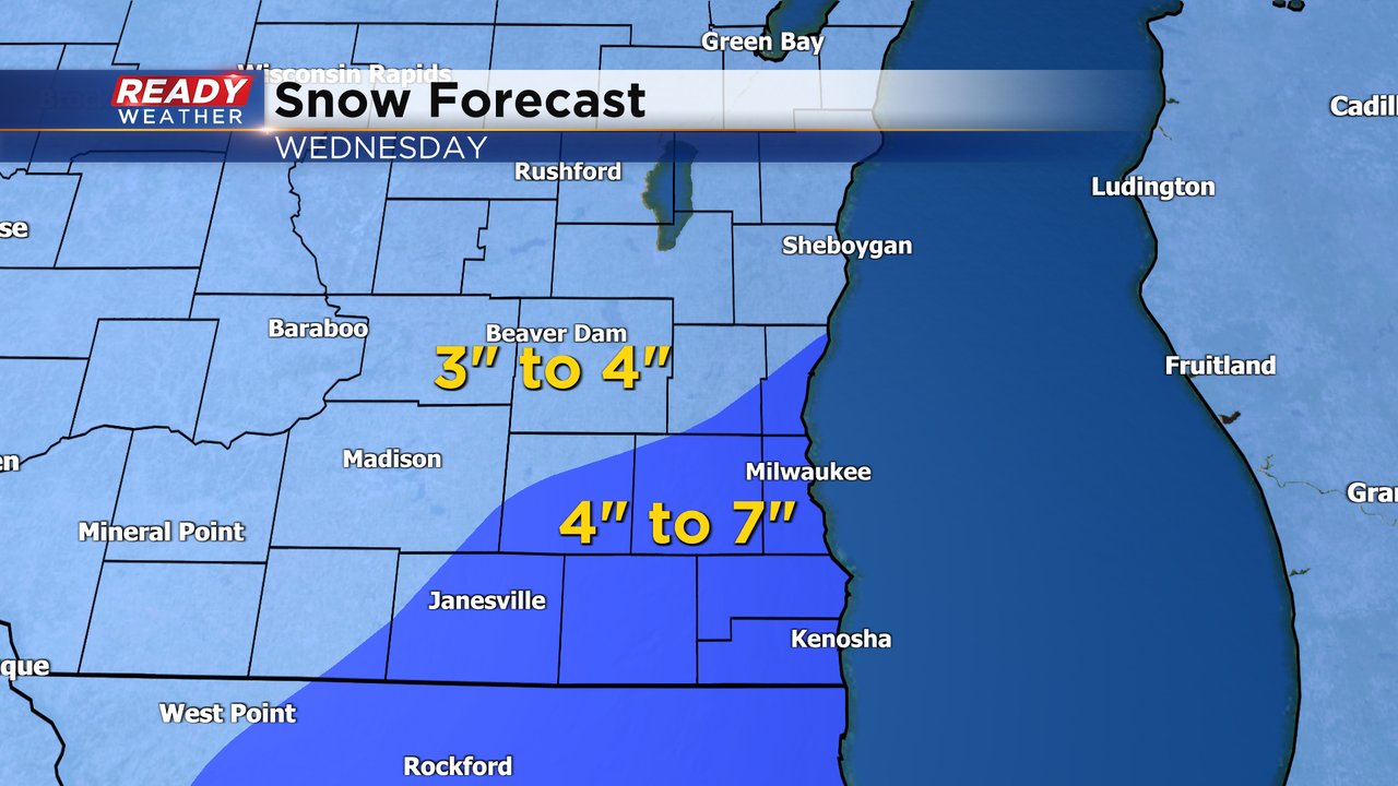
There have been no big changes to the snow map for Wednesday. About 3-6" of snow is expected for most of southeast Wisconsin, but some lakeside areas could get close to 7" with some lake enhanced snow thanks to a NE wind.
While the snow will not be overly heavy at any time we could see about a half inch per hour rates of snow during the afternoon and evening which will definitely allow the snow to accumulate on the roadways and make the evening commute very difficult. With some of the breeziness and the fluffy nature of the snow some reduced visibility is likely. Cold air will not be a big issue with the storm.

Download the CBS 58 Ready Weather to track the snow with the interactive radar.