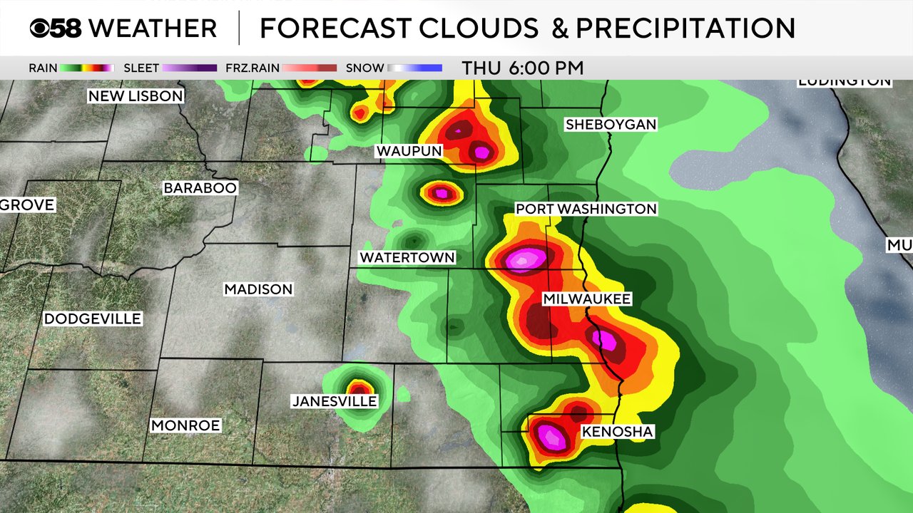
3:30 PM Update: New tornado watch updated


Update: 3:30 PM May 15, 2025

A new tornado watch has been issued for all of southeastern Wisconsin. Conditions continue to be favorable for strong to severe storms between 4 pm and 8 pm.
West of the lake a spike in temperature and deeper humidity is creating a pocket of instability. Storms that fire in that environment could be explosive. Wind shear will produce rotating storms capable of producing large hail, damaging winds, and tornadoes.
Timing for storms remains between 4pm and 8 pm.
_____________________________________________________________________________________________________________
Midday: 12:00 PM May 15, 2025
It's the hurry up and wait game this afternoon. Waiting for storms to fire ahead of a cold front later in the day, especially between 4 and 8 PM. All kinds of severe weather modes, including tornadoes are all possible. Stay tuned to CBS 58 on air and online for further details.


_____________________________________________________________________________________________________________
Updated: 9:40 a.m. May 15, 2025
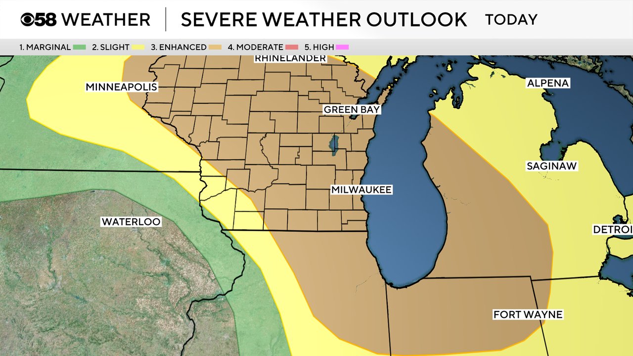
There are no changes to the ongoing forecast for severe weather on Thursday. After a dry morning and early afternoon storms are expected to fire in the mid-afternoon hours and last through the evening. 4-8 PM remains the peak time period for storm activity. There has been no change to our severe weather risk as all of southeast Wisconsin remains under a Level 3 Enhanced Risk.
Weather models have stayed very consistent bringing storms in. Eerily consistent which brings more concern with it. One thing that may limit the severe potential locally is if storms don't pop until they are right over us. If that happens they will only have a short time to grow before hitting the lake breeze and eventually dying. if storms form to our west closer to Madison, that would increase our potential for severe storms especially in western counties.
------
Posted: 5:32 a.m. May 15, 2025
Thursday is one of those rare days in Wisconsin where not only are severe storms likely, but strong tornadoes are possible. We've been talking about the severe threat across Wisconsin for a few days now and not much has changed in the forecast. When forecasting severe weather we look for consistency and we have certainly seen that the last few days. Weather models continue to forecast strong to severe storms for the afternoon and evening hours and all of our severe weather ingredients. Bottom line: be prepared for severe weather including the possibility of tornadoes.
Timing for the storms looks best from the late afternoon through the evening. If you have morning or lunchtime plans or errands to run you will be just fine, but around 3 PM start heading home. The peak window for storms in southeast Wisconsin will be from 4-8 PM.
The tornado threat for Thursday has increased and is now high long with the possibility for large hail over 2" in diameter and damaging wind gusts. Downed trees, power outages and hail damage to homes and vehicles will be possible. Clearing out some space in the garage to park your car or finding a covered location will be a good idea for the afternoon and evening hours. The tornado threat is very real in Wisconsin, in fact the Storm Prediction Center has eastern Wisconsin with a 10% chance for tornadoes including the possibility for violent tornadoes over EF0-2 in strength. The average Wisconsin tornado is a weak EF-0 or EF-1 so the possibility for tornadoes over EF-2 in strength is rare.

Most of Wisconsin remains under a Level 3 Enhanced Risk for severe weather including all of southeast Wisconsin. There is a possibility that part of the state could be upgraded to a Level 4 Moderate Risk with later updates throughout the day.
Download the CBS 58 Weather app to track the storms with the interactive radar, get alerts when watches and warnings are issued, and see the hour-by-hour forecast to watch when storms are most likely where you live.