Winter Weather Awareness Week in Wisconsin as we get ready for the cold months
This week has been Winter Weather Awareness Week across the entire state of Wisconsin. It's a chance to get ready for the cold weather months and review the different types of weather headlines we see, precipitation types we get and the dangerous cold air.
When a winter storm or blast of dangerous cold air looks to be moving our way the National Weather Service will issue a "watch" one to three days out. The "watch" is a heads up that impactful weather is expected to move our way. About 24 hours out from that weather arriving the "watch" would get upgraded to either a "warning" or "advisory" depending on the level of severity. It's also possible that the storm doesn't look as impactful and no headline may be needed.
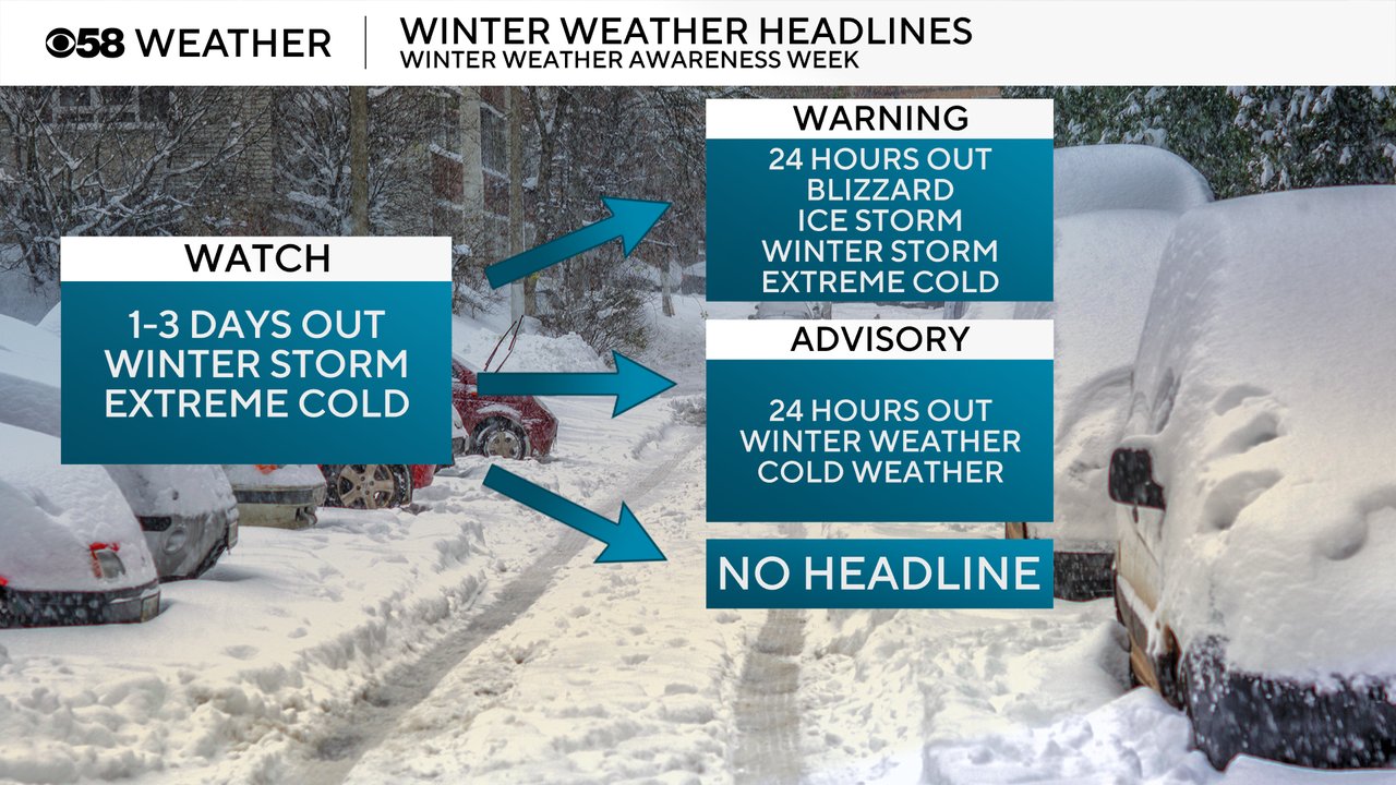
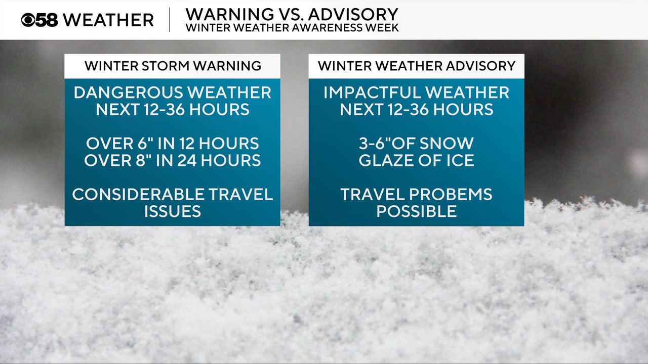
A "warning" is worse than an "advisory". A Winter Storm Warning is issued for dangerous weather happening over the next 12-26 hours typically for 6" of snow in 12 hours or 8" of snow in 24 hours with dangerous travel issues. A Winter Weather Advisory is issued for lesser snow events but still impactful weather with 3-6" of snow or a glaze of ice. These are not hard thresholds and there is wiggle room for the intensity of the snow and when it falls. For example if 2" of snow is expected to come down quickly during the evening commute an advisory might still be issued even if it doesn't meet that 3" threshold.
A Blizzard Warning is reserved for those huge, big storms. It's pretty hard for most of southeast Wisconsin to see true blizzard conditions thanks to the trees and river valleys. It's a bit more possible in Central Wisconsin and the Plains states where they have more open land. The criteria for a Blizzard is sustained wind over 35 mph AND visibility under a quarter mile AND both of those for at least three hours.

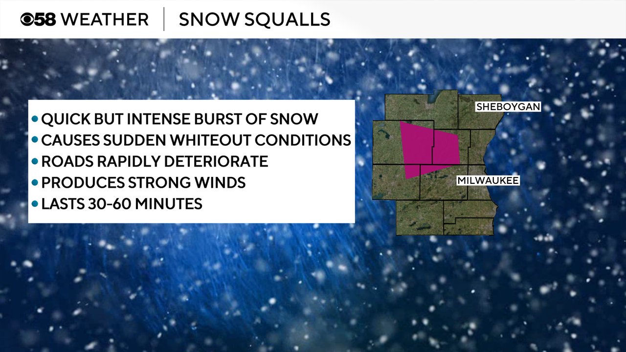
A warning that still relatively new is a Snow Squall Warning. These are quick, intense bursts of snow that cause sudden whiteout conditions and treacherous road conditions. They typically only last 30-60 minutes. Usually, a Snow Squall Warning will only be issued when an advisory or warning is not already in place. They are extreme enough where an alert would be sent to your phone if one was issued during the day.
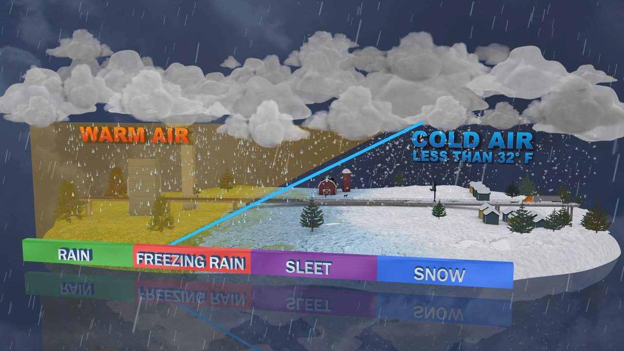
During the winter months we can get all different kinds of precipitation from rain to snow and everything in between. The temperatures at different levels of the atmosphere can determine what type of precipitation we see. Rain is when we have temps above 32 from top to bottom in the atmosphere and snow is when we have temps under 32 from top to bottom. Freezing rain happens when you get an intrusion of cold air right near the surface so the water droplet falls as rain but then freezes on contact as it hits the ground/trees/cars/etc. Sleet forms when the droplet starts as water but then hits cold air which forces it to freeze into an ice pellet.
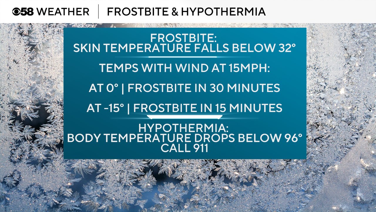
While snow may be the more "fun" winter weather, cold air can be just as, if not more, dangerous. Frostbite happens when the skin temperature falls below 32 degrees. Frostbite can form in 30 minutes with an air temperature of 0 and a wind speed of 15 mph. That time to frostbite drops to 15 minutes with air temps at -15 and a 15 mph wind.
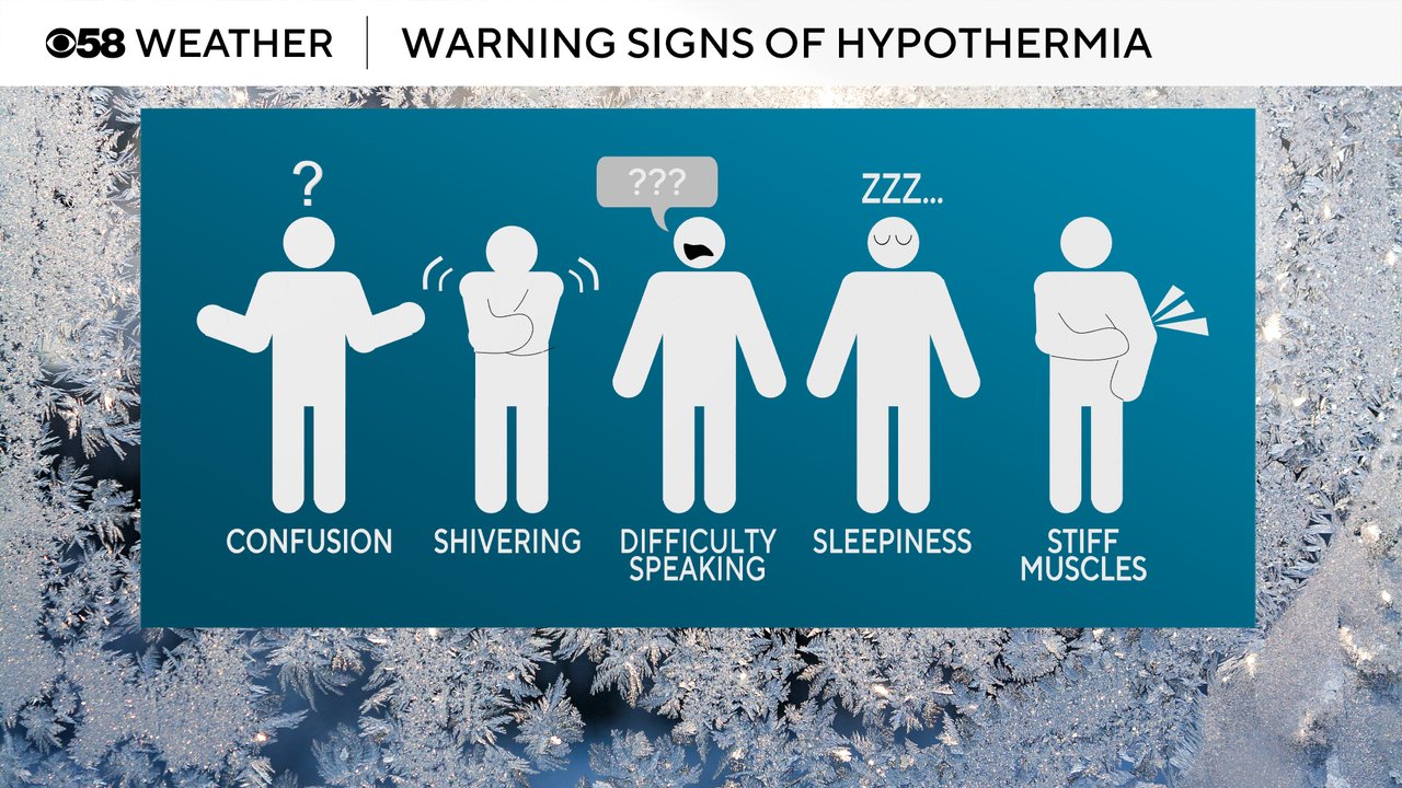
Hypothermia can be even more dangerous when the body temperature drops below 96 degrees. Call 911 if someone is cold and is experiencing some or all of the following: confusion, whole body shivering, difficulty speaking, sleepiness and stiff muscles.
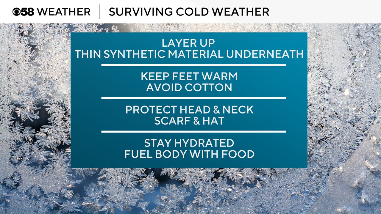
Some ways to combat the cold including wearing the proper clothing. Layering up with a thin synthetic material underneath is important. Keep your feet warm but avoid cotton since you can sweat easier, wool is better. Protect all exposed skin including your head and neck with a scarf and hat. It's also important to stay hydrated and fuel your body with food.
Last winter there were some changes to our cold weather headlines. To make wording more inclusive and universal the National Weather Service did away with the "wind chill" wording and went to "extreme cold". An "Extreme Cold Watch/Warning" is now issued for wind chills of -30 degrees or colder. The old threshold was -35 so it's possible we see those watches/warnings a bit more frequently. A Cold Weather Advisory (previously called a Wind Chill Advisory) is issued for wind chills of -20 or colder.

Download the CBS 58 Weather app to track the snow and cold as we head into the winter months.
