Overnight Update: Heavy snow and low visibility continue.


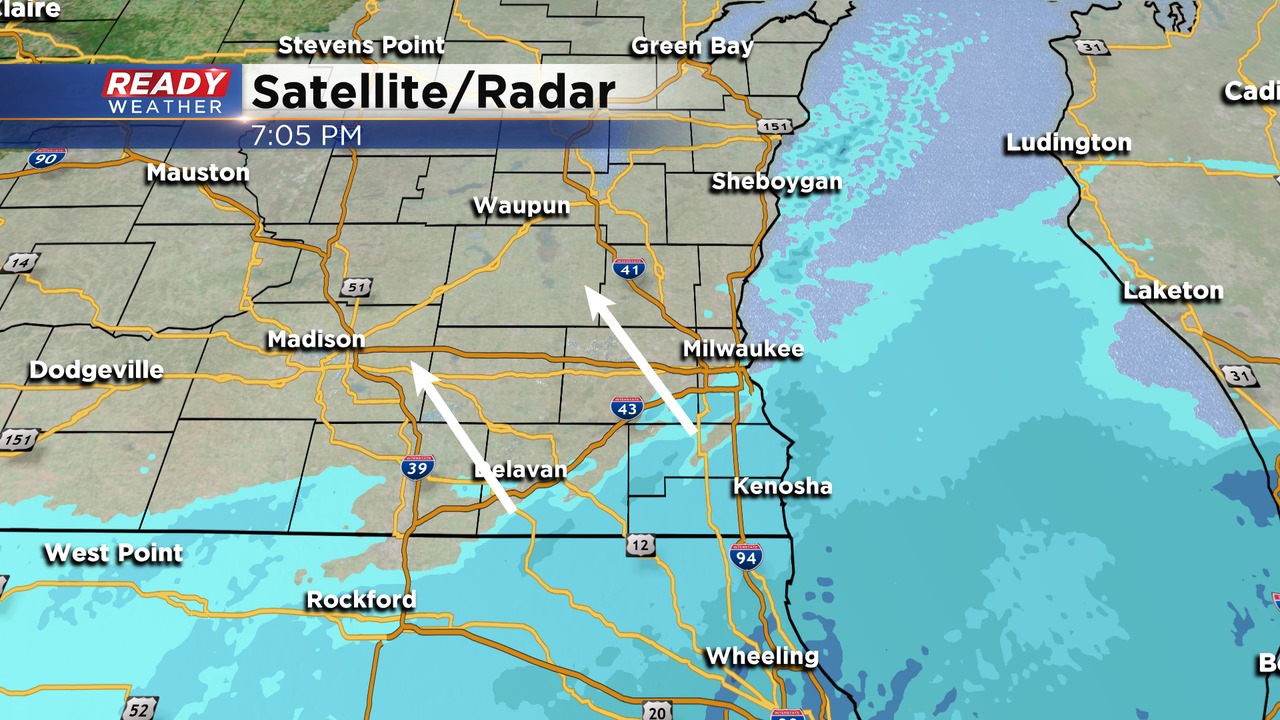
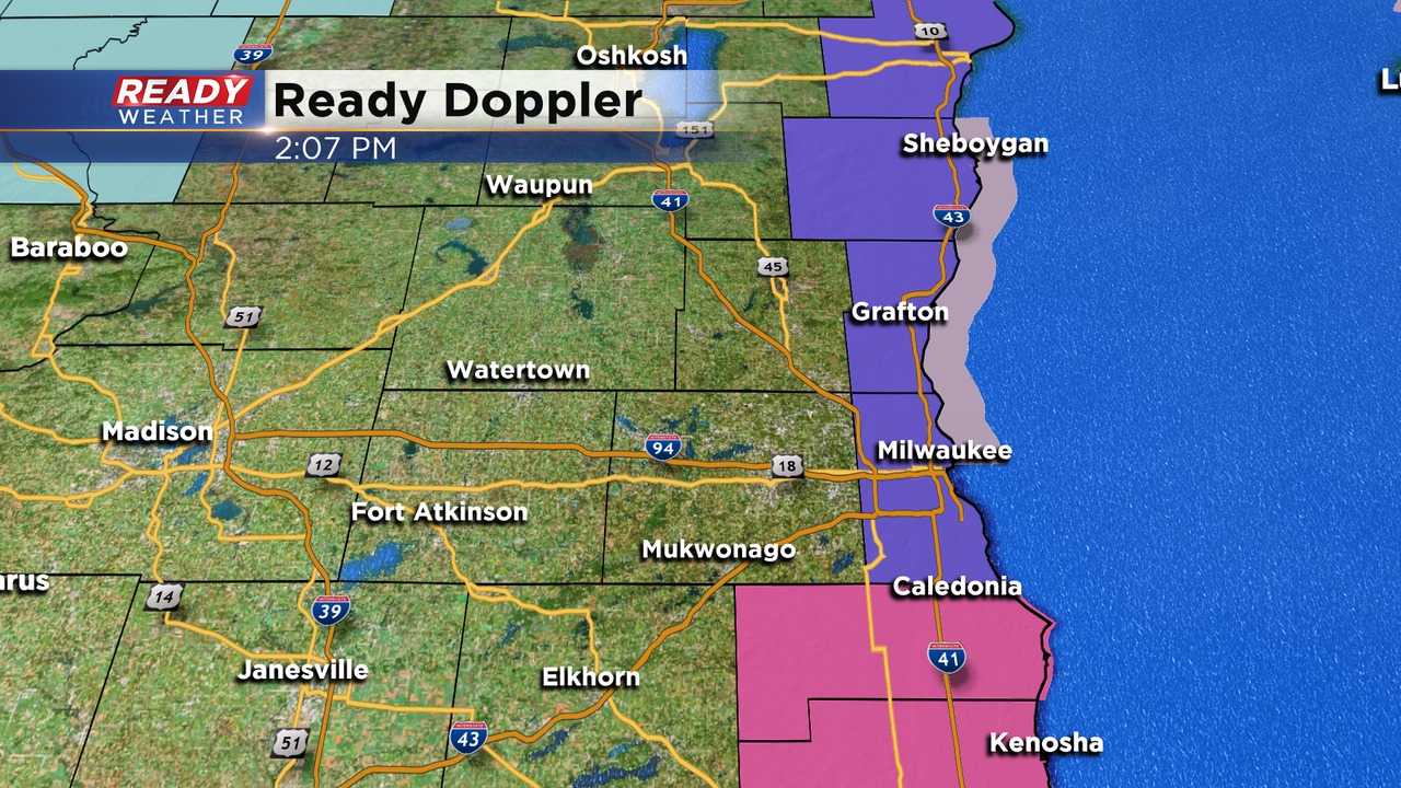
Snow continues to move throughout southeastern Wisconsin. There have already been snow reports of 6" in parts of Kenosha county! Lake enhanced snow along the lakefront will remain an issue tonight through the morning.
Snow is reducing visibility and already causing dangerous travel across the area. Single digit temperatures will create a very slick surface, especially on bridges, overpasses, and ramps. Main interstates are snow covered tonight.
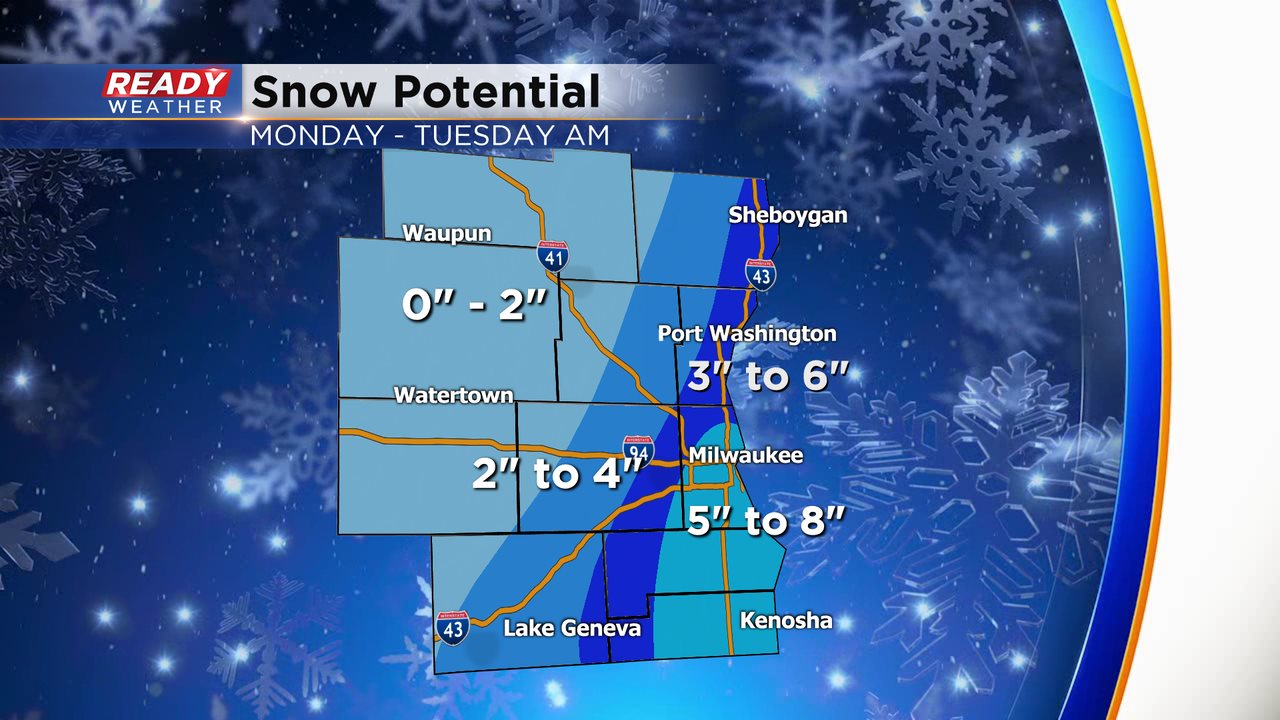
5" to 8" within the warning is likely. I wouldn't be surprised if areas in the warning get some higher isolated totals. We have updated the totals to push the 5" to 8" across Milwaukee county.
We also pushed the 2" to 4" band further west. There will likely be a sharp cutoff across our northwestern counties. Ozaukee and Sheboygan counties are the wild card. If lake enhancement occurs there they could easily reach 3" to 6" of snow.
The wind will also keep wind chills between -10 and -20!
Snow should move out during the morning commute; however, snow could linger lakeside through 10 am.
______________________________________________________________________________________________________________
7:00 PM Update:
No changes to the warning or advisory areas. While it has been on and off snowing with lake effect across the warning area since this afternoon, more widespread snow is pushing in from the south.
We do expect more widespread snow to develop across the area by 10 pm. Temperatures remain in the single digits, so roads will quickly become impacted by any snow.
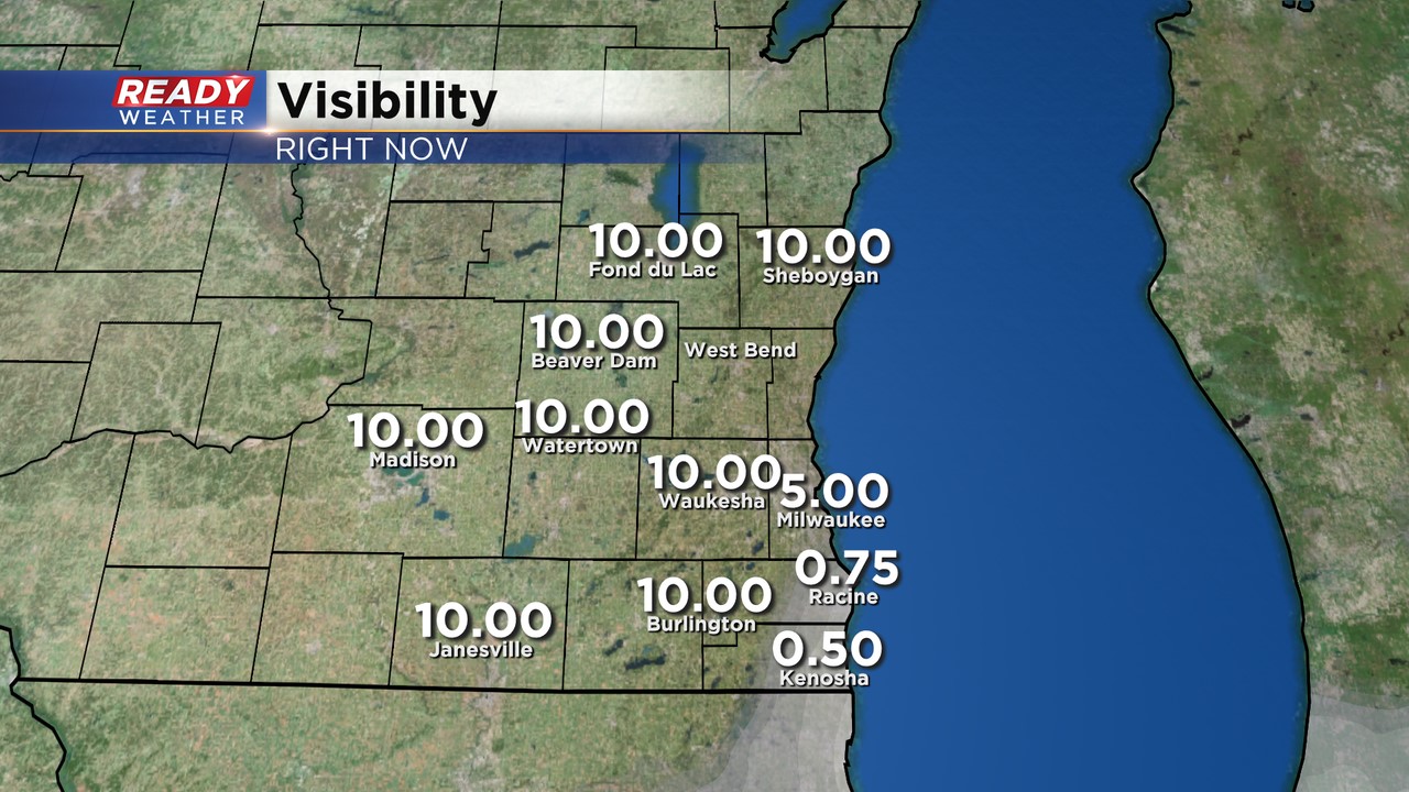
Low visibility and poor road conditions will lead to major problems! Low visibility is being reported below a mile within the winter storm warning.
______________________________________________________________________________________________________________
5:00 PM Update:
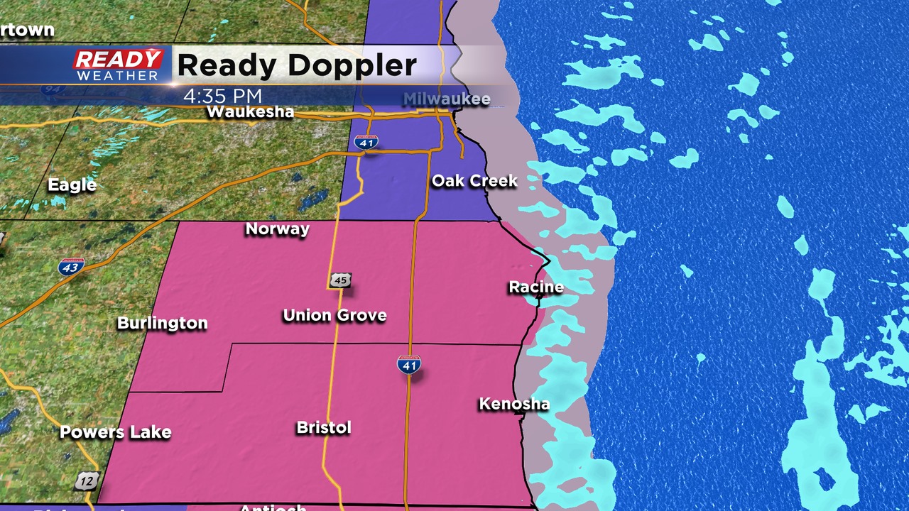
A lake effect band is starting to show up across Racine and Kenosha counties. The localized snow will remain there this evening before more snow pushes north from Illinois.
Expect the snow to arrive between 6 pm and 9 pm from south to north! The snow will continue overnight and linger lakeside tomorrow morning through 8 am.

Our computer models have consistently gone up on snow totals across our far southeastern counties this afternoon. The lake will come into play to help produce the heaviest totals across Racine, Kenosha, and southern Milwaukee counties. 5" to 8" of snow is possible there.
We are going 3" to 6" within the deep blue band. Most areas west will pickup 2" to 4".
The snow totals really drop-off the further northwest you go. It's possible that Dodge, Jefferson, and Fond du Lac counties miss out on most of the snow. There is a lot of uncertainty there.
Temperatures will once again be in the single digits and the teens, so plan on the roads to be a mess. It's extremely hard to treat them when it's this cold. Allow plenty of extra time for your Tuesday morning commute.
______________________________________________________________________________________________________________
3:30 PM Update:
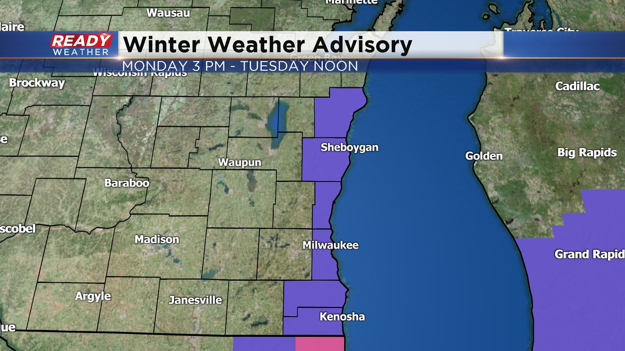
The winter weather advisory and the winter storm warnings have been pushed back until 6 pm. They expire at Noon on Tuesday. Snow will begin to develop between 4 pm and 8 pm. Snow will be heavy at times after midnight and move out late Tuesday morning.
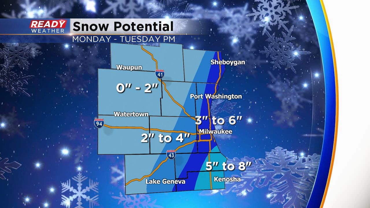
Our computer models have consistently gone up on snow totals across our far southeastern counties this afternoon. The lake will come into play to help produce the heaviest totals across Racine, Kenosha, and southern Milwaukee counties. 5" to 8" of snow is possible there.
We are going 3" to 6" within the deep blue band. Most areas west will pickup 2" to 4".
The snow totals really drop-off the further northwest you go. It's possible that Dodge, Jefferson, and Fond du Lac counties miss out on most of the snow. There is a lot of uncertainty there.
Temperatures will once again be in the single digits and the teens, so plan on the roads to be a mess. It's extremely hard to treat them when it's this cold. Allow plenty of extra time for your Tuesday morning commute.
______________________________________________________________________________________________________________
2pm Update: Racine and Kenosha counties have now been upgraded to a Winter Storm Warning. The timeframe remains the same beginning at 6 pm, however, latest data points to snow totals which could be more in the 6-8" range. As lake effect bands take shape and move inland be prepared for quickly changing conditions. As you travel south skies may abruptly change if you encounter these snow bands.

1pm Update: The one-two punch of cold air and snow is back for Monday into early Tuesday. While the Wind Chill advisory has expired, the chills will remain colder than -10 all day Monday and won't really improve until Tuesday afternoon.
Additionally, A Winter Weather Advisory has been issued for our lakeside counties (Sheboygan, Ozaukee, Milwaukee, Racine, Kenosha) from 3 PM Monday until noon on Tuesday. The advisory is for the combination of snow from a storm system to our south as well as lake effect.
The snow will start Monday afternoon, becoming heavy at times Monday evening through early Tuesday morning and ending with flurries Tuesday afternoon. Some flurries are also possible on Wednesday. There is still a high level of uncertainty surrounding the snow chance with most of the heaviest snow coming from lake effect as well as being on the northern edge of the storm system to our south. Some spots may end up getting less or even no snow, but if the lake effect really ramps up then snow totals may be a bit higher.

As of Monday morning it looks like our NW areas like Fond du Lac and Beaver Dam will see the least snow with less than an inch there and they might not see anything. Inland areas like West Bend, Waukesha, Lake Geneva, etc. have the possibility of 1-3" of snow. Highest totals will likely happen lakeside in Ozaukee, Milwaukee, Racine and Kenosha Counties where 3-6" of snow is possible from Monday afternoon through all of Tuesday.

Anytime lake effect is part of the equation some heavy snow is a possibility and road conditions could deteriorate rapidly. Depending on when a lake effect band arrives this afternoon, the Monday evening commute could be impacted. The Tuesday morning commute could also see some impacts. Although not as cold as this weekend there will still be a bite to the air with wind chills staying below-zero until Tuesday afternoon and the wind will be blustery so still some impacts there.

Download the CBS 58 Ready Weather app to track the snow with the interactive radar and see any forecast changes.