A severe thunderstorm watch has been issued for parts of our area until 11 pm.


7:30 pm Update:
A severe thunderstorm watch has been extended into Walworth, Jefferson, and Waukesha counties until 11 pm. There is a line of storms that has been slowly moving from west to east, but those haven't been the problem.
The atmosphere in northern Illinois has been ripe for storms. Storms have popped there and are moving northeast. If they hold together they will have a chance to become strong to severe.
_____________________________________________________________________________________________________________
6:00 pm Update:
A severe thunderstorm watch has been issued just to our west. Dane and Rock counties are included in this watch that goes until 11 pm.
That area missed out on the storms from this afternoon, so the atmosphere is more primed for strong to severe storms. Closer to home the afternoon storms did use up energy, but there is some recovery that's occurring
Any storms that fire over the next couple of hours have a chance to produce some hail and gusty winds. Our severe weather threat is very conditional from now until 11 pm.
_____________________________________________________________________________________________________________
Monday was the warmest day in over two weeks for most of southeast Wisconsin when the high temperature reached 80 degrees in Milwaukee. Tuesday is expected to be even warmer with highs reaching the mid to upper 80s potentially making it the warmest day of the year. The wind gusts will be higher as well out of the southwest gusting over 30 mph at times.
All of that warmth will provide fuel for some storms Tuesday afternoon and evening and lingering rain through at least Wednesday morning. Weather models are starting to pick up on the threat for some storms in the early afternoon. That earlier chance is not as likely as storms in the evening, but if it happens there's a better chance that those storms could be strong or severe.

The better storm chance still looks to be in the evening from 6-10 PM with some heavy rain and stronger thunderstorms. By 10 or 11 PM the threat for strong storms goes away but steady rain and rumbles of thunder will be possible all Tuesday night long with showers lingering through at least Wednesday morning and maybe a bit into the early afternoon.

All of southeast Wisconsin remains under a Level 1 Marginal Risk for some stronger storms on Tuesday or a borderline severe storm. Widespread severe weather is not expected. in fact, the Level 2 Slight Risk for severe weather was pushed farther to our southwest.

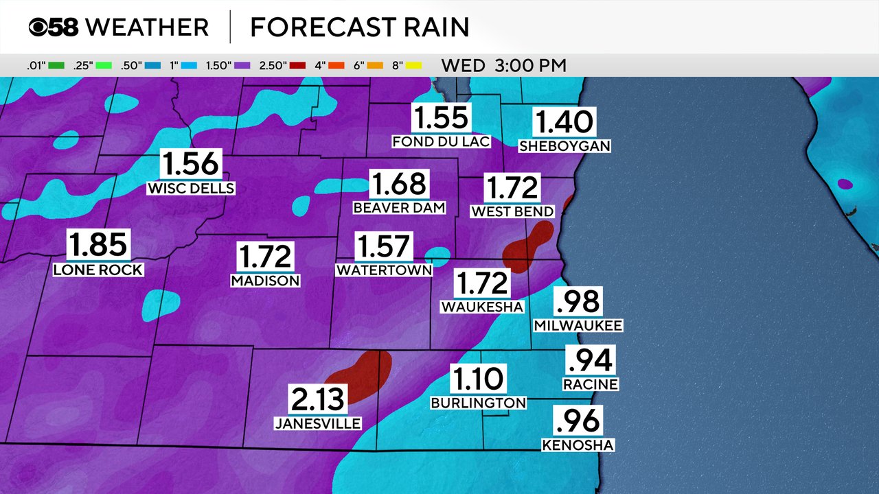
Heavy rain is a pretty good possibility through midday Wednesday with a good chance for over an inch of rain in some locations. Over 2" of rain is possible in some areas. The storms will overall be slow movers and any heavy storms will increase totals. Steady overnight rain with some rumbles of thunder into Wednesday morning will continue to add to rain totals.
Minor street flooding and some gusty wind will be the other big risks with any strong storms. There is a low threat for weak, short-lived tornadoes and some small hail as well.
Download the CBS 58 Weather app to track the timing of the storms and get any alerts in case warning are issued.