Early afternoon update: Severe threat will stay across Illinois.


Updated: Thursday, June 13th 2:15pm:
There is some good news to pass along. Severe weather will NOT be around for us this afternoon and evening. Morning showers that came through pushed an outflow boundary across northern Illinois. This boundary will serve as a focus for showers and storms to our south.
A severe thunderstorm watch has been issued for parts of northern Illinois.

A cold front will arrive this evening and drop our humidity and temperatures for tomorrow!
______________________________________________________________________________________________________________
Updated: Thursday, June 13th 1:15pm:
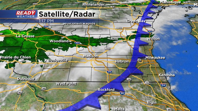
We continue with hot and humid conditions early this afternoon from Milwaukee and points south. At this point the cool front is already working into the area. Behind the boundary we find weaker showers working east. Out ahead of it clouds for additional storms are bubbling near and south of the Wisconsin state line. While storm chances aren't zero, most of us will miss out on any storms today, but will continue to watch for anything to fire near the Wisconsin - Illinois border this afternoon.
Updated: Thursday, June 13th 11:00am:
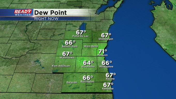
All remains quiet late this morning across southeast Wisconsin. Temperatures hover at the same mark as yesterday at this hour. The difference you'll feel is a higher dew point, check out the numbers:

Updated: Thursday, June 13th 9:20am:
The area of showers and storms held together throughout southeast Wisconsin early this morning, but they cleared out quickly along with the clouds.

Hot and humid weather continues into the early afternoon ahead of the cold front. The earlier round of rain has pushed the better severe risk to our south. That being said, folks in Walworth and Kenosha counties may see a strong to severe storm between 1-4pm today before the cold front pushes south.


-------------------------------------------------------------------------
It's a warm and humid start to the day across southeast Wisconsin with a round of rain and storms pushing through the area.

This round of rain will leave a boundary somewhere across southern Wisconsin or northern Illinois, which will be the focus for a round of severe storms this afternoon ahead of a cold front. Storms look to fire between 1-3pm. Regardless of where storms pop, they will be strong to severe given our hot and humid conditions that are expected throughout the morning.

The best chance for these strong to severe storms will be south of I-94, likely closer to the IL border. Kenosha is included in the level 2 of 5, Slight Risk, for severe storms with a level 1, Marginal Risk, elsewhere in SE WI.

Humidity drops later this evening and will be at comfortable levels through Saturday, but hot and humid weather returns Sunday through Wednesday with highs near 90. Download the CBS 58 Ready Weather App to get updates and alerts sent to your phone.