Everything you need to know about Thursday's historic February tornadoes


Updated: Friday, February 9th 6:25pm:
More information has been confirmed by the National Weather Service regarding Thursday's tornadoes. The EF-2 tornado that tracked from Evansville to Lake Koshkonong had peak winds speeds of 135 mph and was on the ground for 24.5 miles. It had a maximum width of 500 yards.

A second tornado was also confirmed from Thursday in Green county. An EF-1 tornado with peak winds of 110 mph touched down west of Juda and lifted SE of Albany.

-----------------------------------------------
Updated: Friday, February 9th 2:45pm:
The National Weather Service has rated the Evansville to western Fort Atkinson tornado a preliminary high-end EF-2 tornado.

Additional information regarding the path length, width of the tornado, maximum wind speeds, and damage will be released later today once the NWS survey team has completed their survey.
-------------------------------------------------------------------------------
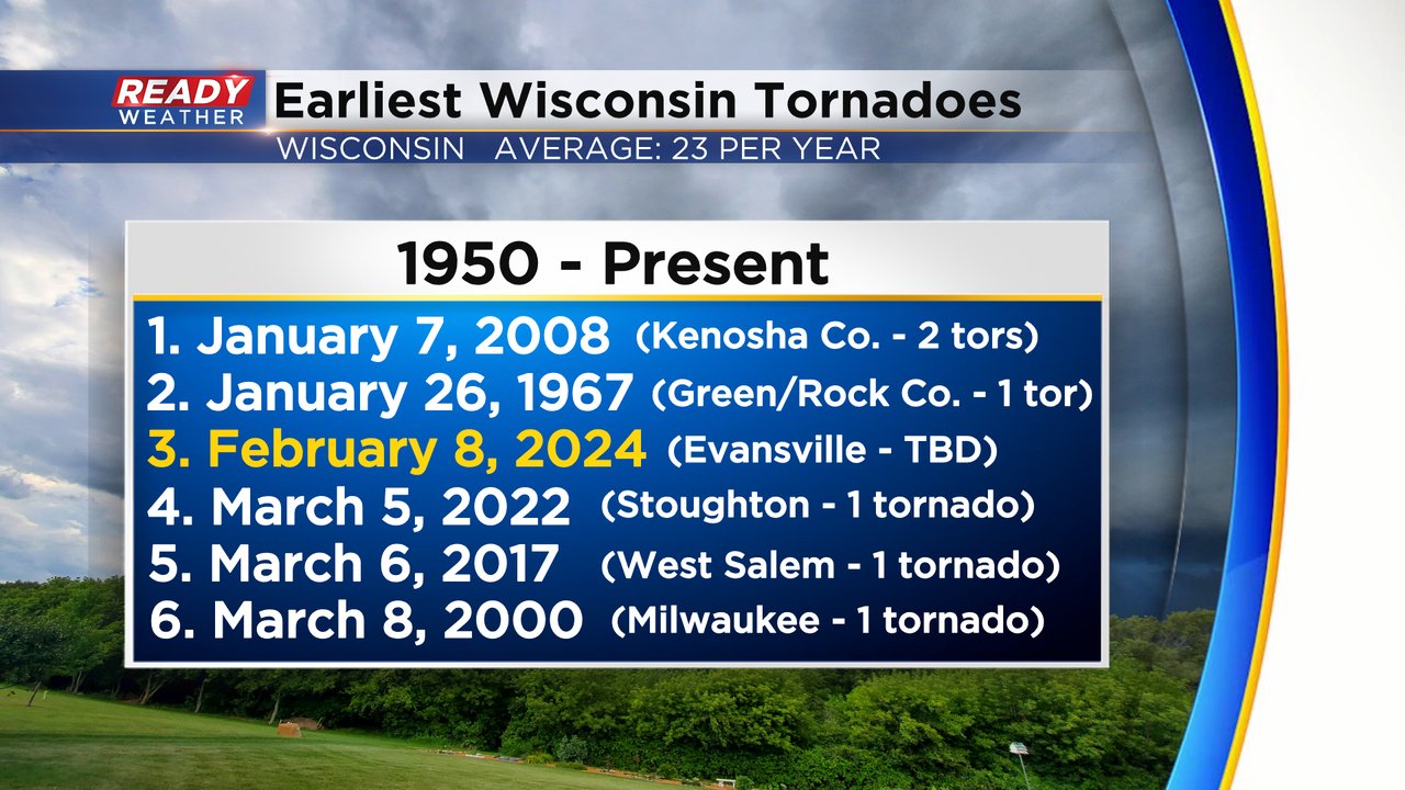
Thursday was a historic day for weather in the state of Wisconsin. While we don't yet know the exact track or strength of the tornado, it was the first time in recorded weather history that a tornado was reported during the month of February. Multiple storm spotters reported a tornado. Check out the graph below. Wisconsin is used to tornadoes from April through September and occasionally gets them during the fall and winter months but February 8, 2024 was the first tornado recorded during the month of February.

Notice how it's not the earliest tornado in a calendar year. Previously, three tornadoes have been reported during the month of January. Two of those happened in Kenosha County in 2008 and one was reported in a very similar area to Thursday in Green/Rock County in the 1960s. Thursday's tornado(es) will be the third earliest in recorded history.
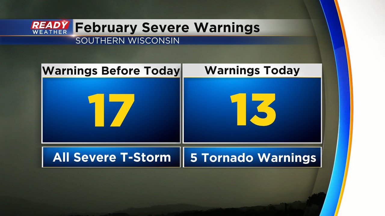
Not only have we never had a tornado reported in Wisconsin in the month of February, before yesterday, but it was also the first tornado warnings we've ever had during the month. Before Thursday, the month of February had only recorded 17 severe weather warnings all for severe thunderstorms. Just Thursday, February 9, we had 13 severe weather warnings issued including five tornado warnings.
As we look back at radar from the storm the storms started strengthening just east of Monroe in Green County then moved through Albany with the first tornado reports of the day before strengthening as it approached Evansville. The tornado may have crossed into southeast Dane County before lifting just west of Fort Atkinson in Jefferson County. Check out the radar loop in the tweet below:
Here's a radar loop of the tornado from yesterday as it started east of Monroe and lifted west of Fort Atkinson. Heaviest damage was reported from Albany to the Jefferson County border. #readywxpic.twitter.com/HkTSSv4ZR3
— Justin Thompson-Gee (@JustinTGee) February 9, 2024
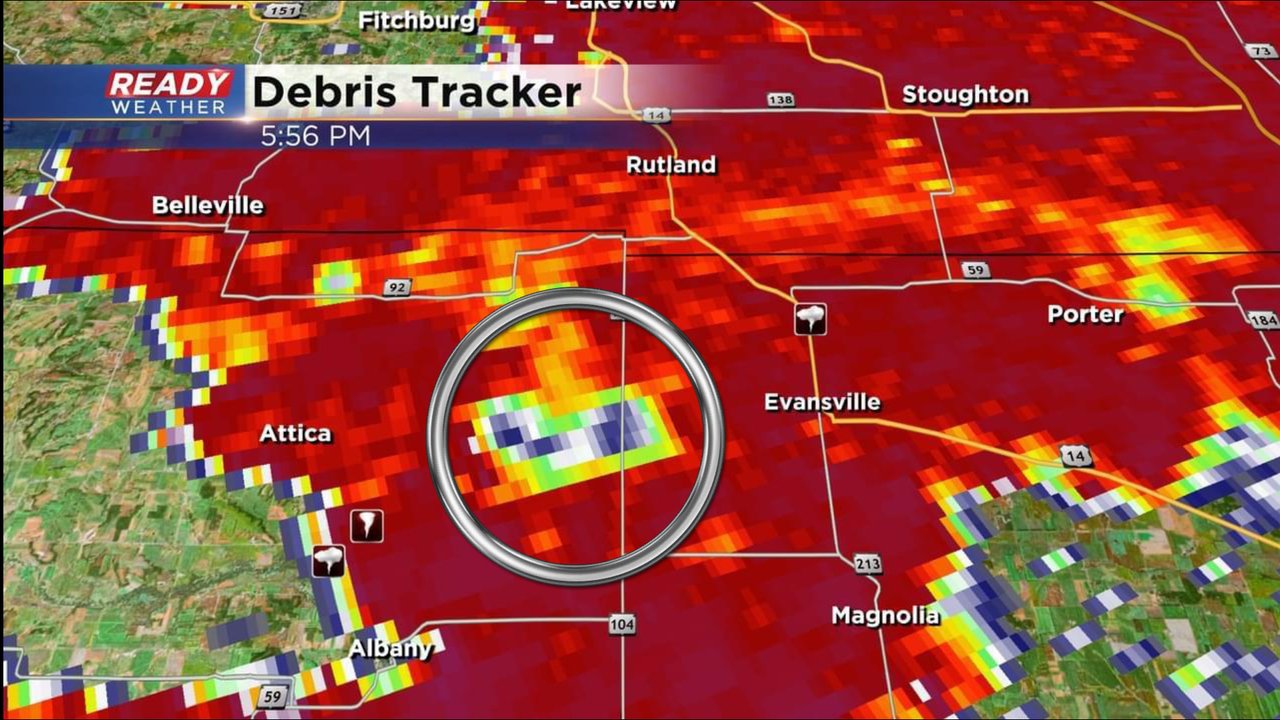
We can use radar to see more than just raindrops and snowflakes. One of the radar products we use can determine with size of the objects it is detecting. Just before 6 PM the "correlation coefficient" radar product was showing something larger than raindrops and hailstones being detected west of Evansville. This shows debris, likely shingles or branches or other material, being lofted into the sky as the tornado moved through.
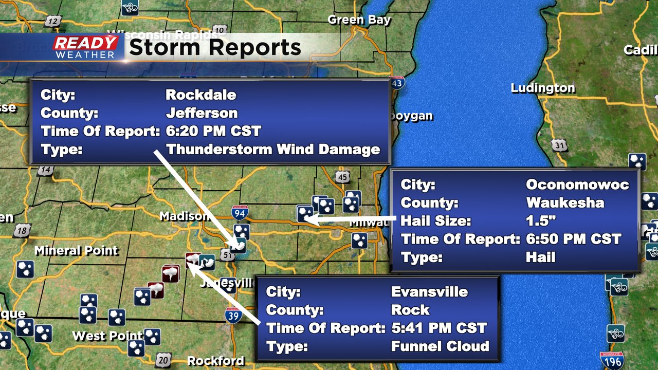
In addition to the tornado reports across southern Wisconsin we also had a report of thunderstorm wind damage in southwest Jefferson County (which could have also been from a tornado) as well as numerous hail reports in and around Waukesha County including a ping pong ball size hail report in Oconomowoc of 1.5".
Thankfully quiet weather is expected over the weekend with some good sunshine. Temperatures Friday are still warm around 50 before dropping in the afternoon. Download the CBS 58 Ready Weather app so you can get alerts the next time severe weather warnings are issued.