Tuesday Mid-Morning Update: Morning storms are done; heat and humidity return


Afternoon Update: It's all clear on the storms and the sun is back too. This will be the hottest and most humid day through our 7-day forecast. At this point additional storms that may reach severe limits should fire south of the border into Illinois.
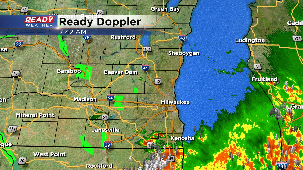
Updated: 7:44 a.m. June 25, 2024
The severe storm threat for Tuesday morning is done. We had a few severe thunderstorms roll through at times since 3 AM Tuesday morning with some hail, wind damage, power outages and wind gusts over 60 mph. The severe thunderstorm watch was canceled early for all of southeast Wisconsin.
Now the focus quickly shifts to the heat and humidity. High temperatures Tuesday reach the low 90s. Thankfully this is brief heat with 70s returning for highs the rest of the work week then a little warmth Saturday in the 80s.
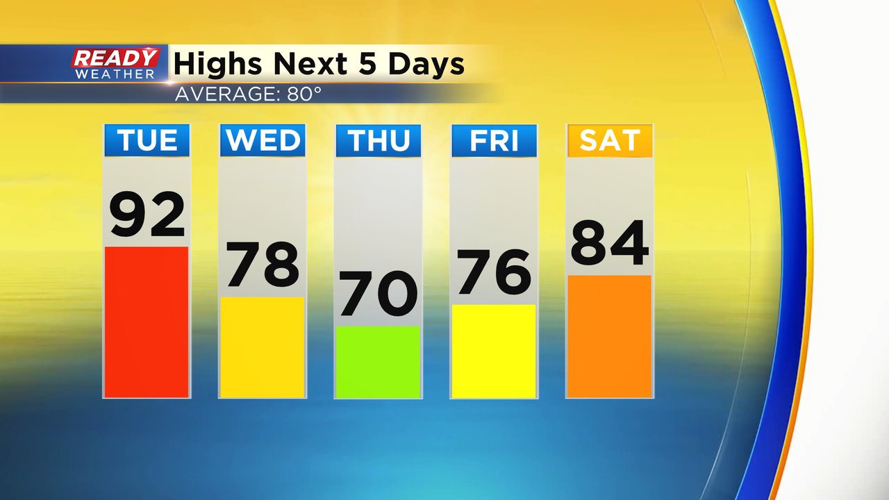
Tuesday could also be the most humid day of the year so far with dew points reaching the middle 70s. The near-miserable level humidity drops on Wednesday with just some mugginess in the morning then becoming comfy in the afternoon. Thursday is a pleasant day.

When you combine the heat and humidity on Tuesday, feels like temps will reach the upper 90s to around 100.

Download the CBS 58 Ready Weather app to track the heat and humidity after the storms.
------
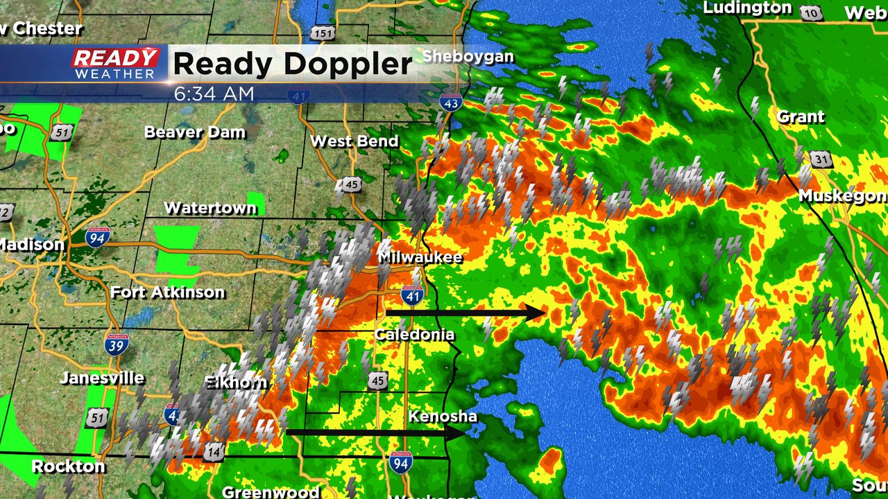
Updated: 6:36 a.m. June 25, 2024
A few severe thunderstorm warnings were issued just before 6 AM as the northern cluster of storm merged with the southern cluster and the storms briefly strengthened for 45 minutes. Those storms have since weakened but not before dropping some 1" size hail and wind gusts around 60 mph.
A line of strong storms is still moving east from northern Waukesha/Milwaukee Counties down to the Lake Geneva area. By 8 AM most of southeast Wisconsin will be dry.
------
Updated: 5:08 a.m. June 25, 2024
A new severe thunderstorm watch has been issued for all of southeast Wisconsin until 11 AM. The main threat for any strong to severe storms continues to be strong wind with some hail here and there but there's no present tornado threat right now.
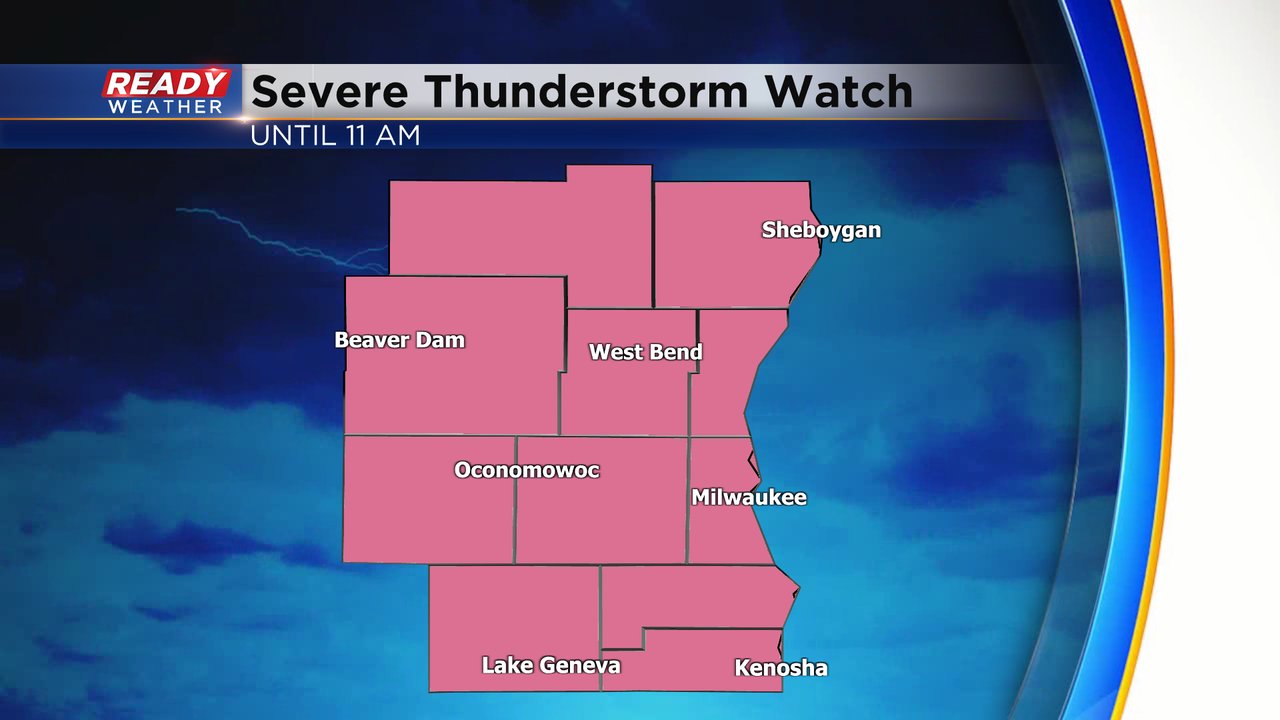
We did have one severe thunderstorm warning until 4:30 AM in our northern counties but the strongest part of that storm then moved over Lake Michigan. While we may not have "severe" storms, we have plenty of lighting and heavy rain with the storms along with wind gusts from 40-50 mph and some small hail.
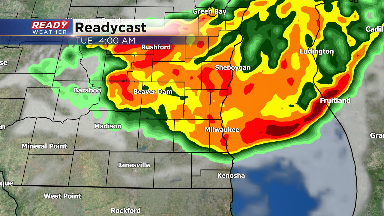
Here's a radar image that will update with time:

------
Updated: 2:27 a.m. June 25, 2024
Strong to severe storms are currently moving through northern Wisconsin. These storms have a history of 50-70 mph wind gusts causing tree damage and power outages as well as some hail. Overall the line of storms formed much farther north in Minnesota Monday evening than weather models were showing causing the storms to arrive locally later than anticipated and likely farther north.
Here's a radar image that will update with time:

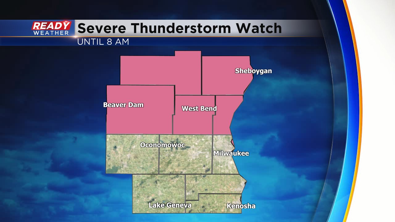
The farther north trajectory of the storms means they may not reach the Milwaukee/Waukesha Metro area at all and if they did, it wouldn't be until after 6 Am Tuesday. The better areas to see the storms will be our local northern counties. Fond du Lac and Sheboygan Counties have the best chance, but parts of Dodge, Washington and Ozaukee Counties could see the storms as well. All of these five counties are included in a brand new Severe Thunderstorm Watch that is in effect until 8 AM.
So far strong wind and some hail have been the main threats with these storms to our north. There's also lots of heavy rain and lightning. The tornado risk so far has been non-existent but an isolated tornado cannot be ruled out as the storms move south, especially as they tap into the daytime heating arriving after sunrise.
------
Updated: 11:17 p.m. June 24, 2024
The current severe thunderstorm watch has been cancelled. The storms have stayed well below severe limits and don't pose a severe risk.

We turn our attention to the northwest as a complex of storms is set to arrive overnight. This is just starting to get organized, so it will likely be several hours before it moves southeast into central Wisconsin.
Severe thunderstorm watches have been issued well to our northwest.
If that complex can take shape, damaging winds will be likely across southeastern Wisconsin. There is also some disagreement at how far south it will actually drop. Some models have it just clipping our northern areas. We will watch and monitor overnight.
------
Updated: 7:30 p.m. June 24, 2024

While this area of storms is not the main show that is expected to arrive overnight, these storms to our west have popped up over the last hour and are moving southeast. These storms have been warned to the west.

There's a chance they will move across some of our western areas this evening. The SPC has issued a severe thunderstorm watch for several counties that could be impacted by these storms. The watch is out until 1 am.
------
Updated: 1:30 p.m. June 24, 2024
Afternoon Update: The severe weather potential for overnight is growing. The entire area has been upgraded from a level two to level three risk for severe storms with what appears to be a potential bowing line of storms pushing through with strong winds.

The timing still appears to be around 2am for northwestern spots like Fond du Lac, hitting Milwaukee around 4am and then out of the area by 8am, leaving the morning commute okay.
------
Posted: 5:25 a.m. June 24, 2024
Parts of southeast Wisconsin are still cleaning up from severe storms and tornadoes that moved across the state on Saturday. As that clean up continues, another round of strong storms is possible Monday night into Tuesday. Those storms likely don't roll in until after midnight and leave the area around 9 AM as they move from north to south across our viewing area.
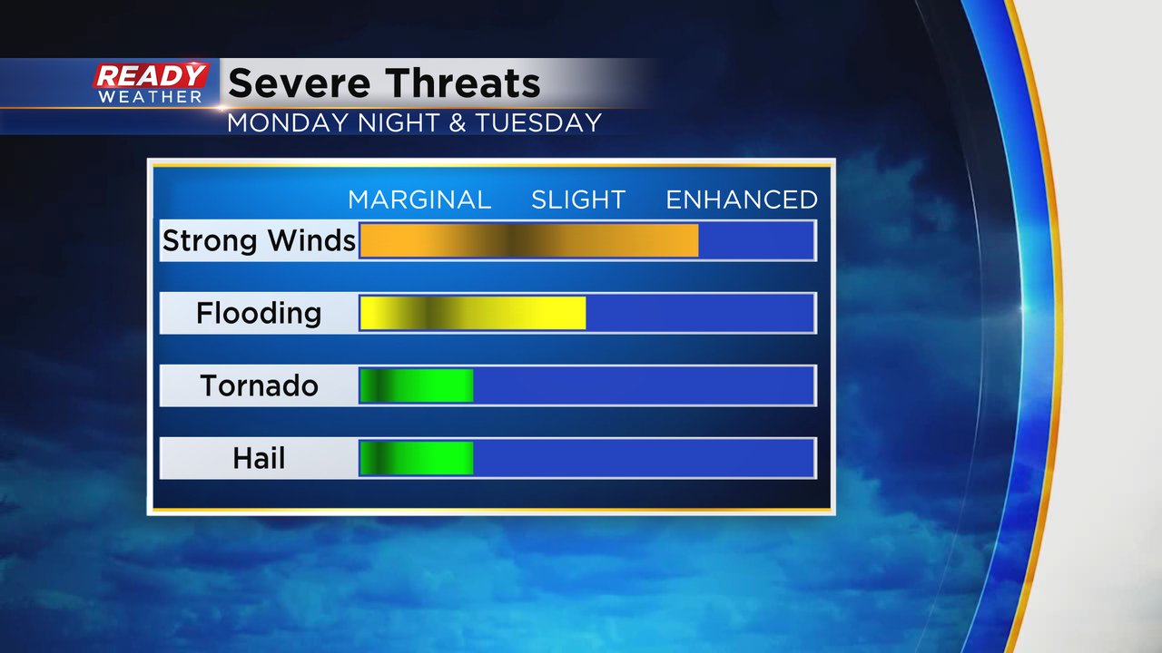
Any of the storms that roll through Monday night could be strong to severe. All of southeast Wisconsin is under a Level 2 Slight Risk for severe weather. Some of the storms could weaken a bit as they move across our area but at least strong storms are expected.

Damaging wind will be the main threats with any severe storms that do develop Monday night. Some flooding rain is possible as well with over an inch of rain possible. An isolated tornado and some hail is also possible.
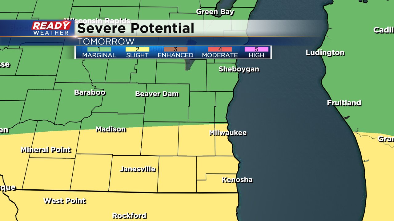
After the storms roll out Tuesday morning, there is some uncertainty whether or not we see storms redevelop in the afternoon and evening. Most weather models keep storms Tuesday afternoon to our south in Iowa and Illinois, but a few do have storms in our southern counties. If those happen they could be on the strong to severe side with lots of heat and humidity to play with Tuesday. A Level 2 Slight Risk has also been issued for Tuesday for that potential.
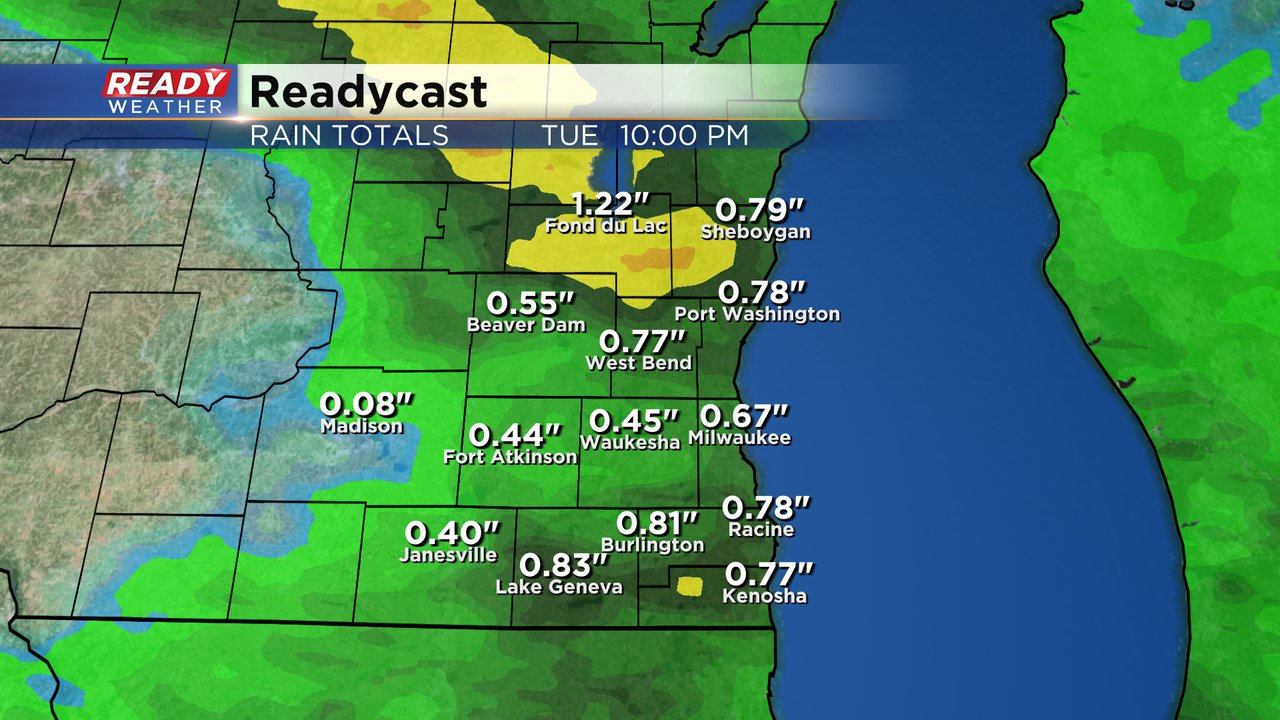
Rain totals from Monday night through Tuesday look like over a half inch for all of southeast Wisconsin with isolated areas getting over an inch if we do see good thunderstorms. Some local communities have picked up 3-5" of rain since the middle of last week so flooding is a concern.
Download the CBS 58 Ready Weather app to track the storms Monday night into Tuesday and get warnings if they are issued.