8:30 PM Update: Some lingering showers, but the severe threat is over.


8:30 PM Update:
The cold front is moving through the area, and that is ending the chance for any strong to severe storms for the rest of tonight. The cooler dry air will cut off any additional storms.
There might be a few lingering showers overnight, but that should be done by Saturday morning. Plan on sun and clouds for Saturday afternoon with highs in the 50s.
______________________________________________________________________________________________________________
6:30 PM Update:
It's been a busy day with multiple rounds of showers and storms across the area. There has been a lull since the afternoon, but now the final round is starting to develop to our west. The window for storms will be from now until 9 pm.

There has been some recovery of the atmosphere near the IL/WI border. Temperatures there are in the 70s with dewpoints in the lower 60s. If storms can develop within that area, they could become strong to severe.
______________________________________________________________________________________________________________
Afternoon Update:
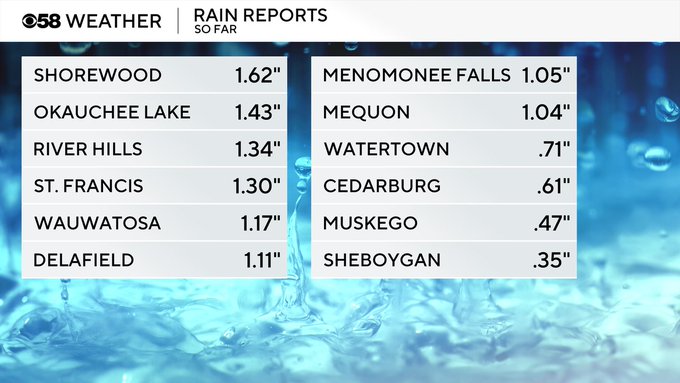
Round one of hefty storms is well out of here. Take a look at some of the soaking rain totals across southeast Wisconsin. Much of which was right through the middle of the viewing area.

That said, our model data still points to storms developing later this afternoon, generally after 3pm and continuing through mid-evening before transitioning to more of just spotty rain showers.

For now, we are monitoring satellite imagery and currently the cloud cover is keeping rain in check:

Stay with the CBS58 Weather team for more updates online and on air as the rest of Friday unfolds.
--------------------------------------------------------------------------------------------------------------------------------------------------------------------------------
Looking at satellite data the clouds may limit how strong the next batch of wet weather becomes. Our Friday morning kicked off with some attention-grabbing thunderstorms as various warnings were issued.
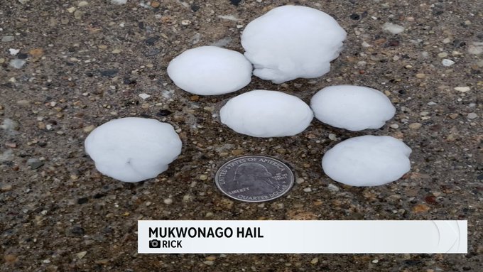
There have been several reports of hail across the area, along with downpours in many backyards. Please let us know what you have seen; send reports and photos/videos to [email protected].
This morning activity should depart the area by about 10am and we'll start to dry out. From there, it's a waiting game to see if another batch of storms forms later in the afternoon. Our threat there is a conditional one, meaning we need a few things to happen.
TO GET STORMS LATER TODAY
•We need clouds to break for an hour or two of sunshine
•We need an incoming cold front to come through at the "right time"
TO REDUCE THE CHANCES FOR STORMS LATER TODAY
•We need clouds to hang around and remain fairly thick
•We need the incoming cold front to slow down
Part of the cause for storms today is the overall setup we have in place:

Areas under that warm front are going to see highs soar into the 70s, while those north of the front will stall out in the 60s.
The location of the warm front will also play a small role in storm development later today. Should the front surge more northward in the state, that may place a few more locales north of Milwaukee into a risk of severe weather.
By this evening, we're expecting the surface low and cold front to slide across the area. This will help give lift to the atmosphere and could spark more storm activity. But again, we would need some instability in place. To get that, we'd need sunshine.
Moving into the holiday weekend, it won't be nearly as warm as today. Saturday looks like the better day as showers enter the picture on Easter Sunday. It turns cooler Sunday with highs stalling in the 40s.
