Storms are Winding Down Tonight


Update as of 9:25 p.m. July 15th

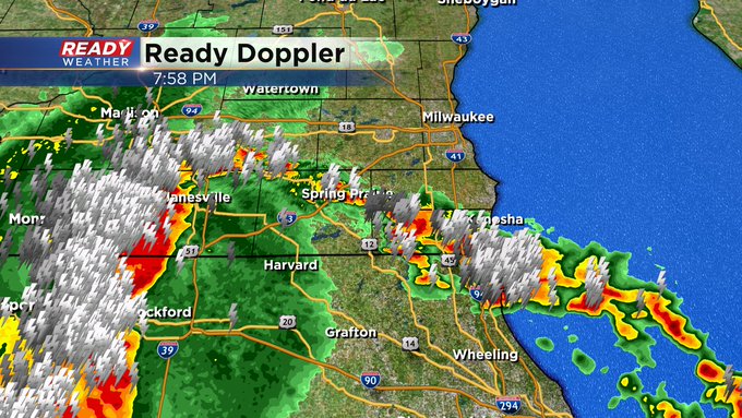
Update as of 8:35 p.m. July 15th
The tornado warned cell has shown some weakening in terms of the rotation. But the potential for straight line winds is still a concern. At this time Walworth county has gone under Severe Thunderstorm Warning due to this potential. It runs until 9;15pm. The storms are moving east at 40mph, which would put the leading edge to the lakefront in an hour.
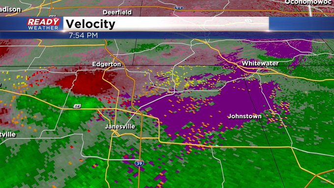
Update as of 8:00 p.m. July 15th
Tornado Warned storms are just west of the viewing area. You can see the rotation being detected on our velocity product. While it's showing some sign of easing up a bit, other wind reports to around 100 mph have come with these approaching storms.
Updated as of 7:00 p.m. July 15th

A new tornado watch has been issued for Walworth, Racine, and Kenosha counties until 1 am. A severe thunderstorm watch has been issued for Milwaukee, Jefferson, and Waukesha counties until 11 pm.
A complex of storms moving east has produced several tornado warnings already, so there is a high likelihood for severe weather to occur across those areas, including damaging winds over 80 mph.
______________________________________________________________________________________________________________
Updated as of 6:30 p.m. July 15th
The complex of storms has taken shape this evening, and it's already producing damaging wind reports between 60 and 100 mph.

Where the brunt of those winds will take aim remains in question; however, we need to take this seriously, especially for our border counites. We don't expect this complex to weaken much as it moves throughout the evening. It's moving into a very favorable environment.
______________________________________________________________________________________________________________
Updated as of 5:00 p.m. July 15th

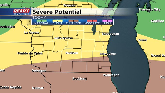
The SPC has upgraded our border counties to a level 4 out of 5 moderate risk for severe weather. The enhanced risk has been pushed further north to include Milwaukee and Waukesha counties.
This event has the potential to produce damaging winds between 60 to 80 mph.

A severe thunderstorm watch has been issued for the western part of the state. This does not include our area as of now. That will likely change.
______________________________________________________________________________________________________________
Updated as of 12:25 p.m. July 15th...
Ongoing forecast remains intact. Minor adjustments to the severe weather outlook bring the level 3 risk for severe storms a bit further north into the Milwaukee metro.
Updated as of 8:25 a.m. July 15th...
An update to pass along from the Storm Prediction Center. The southern tier of the viewing area is now under an "Enhanced" risk for severe weather, especially late in the day and this evening. Gusty winds, large hail, damaging wind, and heavy rain are all possible. But after a cold front moves through late tonight, we get some major relief from the unpleasant conditions. We're talking highs in the 70s much of this week and lows in the 50s and 60s.

Of course, CBS 58 will keep you updated all day and night on air and online. So stay tuned!!
___________________________________________________________________________________________________________
MILWAUKEE (CBS 58)--One more day. Just one more day. A strong cold front will give us relief starting on Tuesday. But we have to endure the heat and humidity for the start of the Republican National Convention. Look for highs near 90, but the humidity will make it feel closer to the mid to upper 90s. And you know with all the humid conditions and a cold front moving in from the west, storms, some strong to severe, are in the works, especially late in the day and through the evening. Perhaps into the overnight as well. In fact, our area is mostly under a slight risk for severe weather. It's a higher category along the Wisconsin-Illinois border. Make sure you have several ways to get weather alerts. Our free CBS 58 weather app is a great device to have for sure, especially when you're on the go.


But once we get passed Monday, look for much better weather as cooler, drier high pressure takes over for the rest of the week, allowing us to dry out for a while. Highs will be in the 70s most of the week with lows in the 50s and 60s. Enjoy this mid-summer weather! We deserve it...
