Early afternoon update: Strong to severe storm threat winding down for today


Updated: Wednesday, July 26th 1:30pm:
Strong to severe storms have pushed out over the lake with only an area of light rain remaining over portions of SE WI.

The three rounds of storms did drop some pretty good rainfall across much of the area. The rounds of storms missed the MKE metro, so rain totals have been much lower here.

Given the three rounds of storms we've already had today, our threat for more storms this afternoon is fairly low. However, we're not out of the woods when it comes to severe weather this week. Our next chance for severe storms arrives on Friday with a cold front. Most of SE WI is already under a Slight Risk (level 2 of 5) for severe storms on Friday.

The cold front that moves through Friday will knock the heat and humidity out of here just in time for the weekend.
---------------------------------------------------
Updated: Wednesday, July 26th 11:56am:
Southern Milwaukee, all of Racine, and northern Kenosha counties are now under a Severe Thunderstorm Warning until 12:30pm.

Radar is currently sampling wind gusts near 60 mph from Waterford to Burlington, tracking east at 55 mph. Head indoors until this passes!

-------------------------------------------------------------------
Updated: Wednesday, July 26th 11:30am:
A Severe Thunderstorm Warning has been issued for northern Walworth, southern Jefferson, and SW Waukesha counties until 12:15pm. 60 mph wind gusts are the main threat with this storm that's racing to the east at 55 mph.

This storm has a history of knocking down trees across Rock county. Stay indoors as this storm passes.
------------------------------------------------------------
Updated: Wednesday, July 26th 10:20am:
The first two rounds of strong to severe storms have pushed out over Lake Michigan, but a third round of strong to severe storms is approaching from the west.

These severe warned storms recently produced major wind damage in Grant County and is booking east at 50 mph. At the current rate, this cluster would reach western Jefferson and Walworth counties around 11:30am.
---------------------------------------------------------------------------------------------
Updated: 8:45 a.m. July 26, 2023
A new severe thunderstorm warning has been issued for Walworth, Racine and Kenosha Counties until 9:30 a.m. This storm has a history of wind damage and downed trees. Wind gusts over 60 mph are possible.

Even after this storm rolls through there are plenty of other areas of rain across the rest of the state so more storms are possible the rest of the day. Any storms that form could be strong to severe.
------
Updated: 8:04 a.m. July 26, 2023
We are watching two areas of storms Wednesday morning. The first to impact our area was in our northern counties. No severe weather associated with this but there was some small hail with wind gusts around 50 mph. Those storms are now moving over the lakefront in Sheboygan County and rolling through Washington and Ozaukee Counties.

A severe thunderstorm warning has now been issued for Walworth County until 8:45 AM for the possibility with damaging wind gusts over 60 mph. These storms are rolling through Janesville right now.

------
Updated: 6:08 a.m. July 26, 2023
A cluster of storms is getting closer and closer to southeast Wisconsin. A few severe thunderstorm warnings have been issued for counties just to our west. This area of storms will likely impact Dodge and Fond du Lac Counties shortly then roll into Sheboygan, Washington and Ozaukee Counties.
The rest of our counties could still get some stronger thunderstorms the rest of the morning.
Wednesday has also trended hotter and now could be the hottest day of the week. That all depends on when the rain and storm chances end but highs could reach the low 90s Wednesday and with dew points around 70 it could feel close to 100 in many hometowns.

------
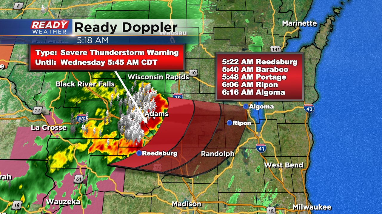
Posted: 4:50 a.m. July 26, 2023
Wednesday morning we are watching a cluster of storms move across the state. So far those storms have behaved in southwest Wisconsin where they are just strong and not severe but a Severe Thunderstorm Watch has been issued there until 8 AM for the potential for severe weather.

If the storms hold together they would arrive in southeast Wisconsin after 9 AM and could linger into the early afternoon. There is a slight chance for some redevelopment with the storms later this evening but most weather models are dry.

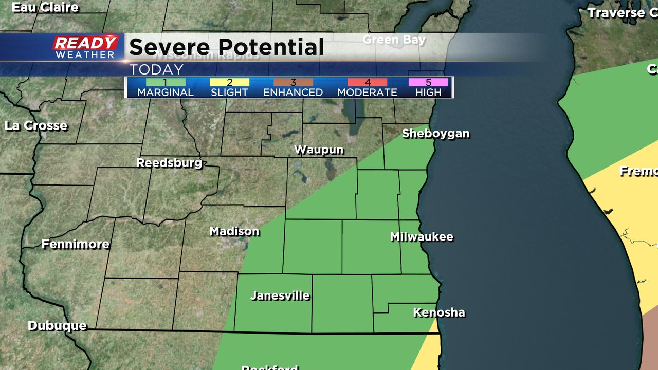
A sliver of Kenosha County is still included in the Level 2 Slight Risk for Severe Weather Wednesday morning. The rest of southeast Wisconsin is in the Level 1 Marginal Risk. Damaging wind would be the main threat for any storms that do develop.
Download the CBS 58 Ready Weather app to track Wednesday's storm chances.