Night-time Update: Scattered storms work out of the area until closer to sunrise


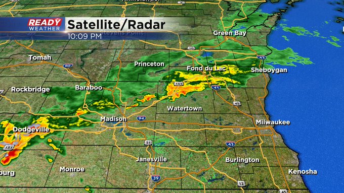
Updated: Friday, June 21st 10:10pm:
Storms are over for most of the area until closer to daybreak. Here's the latest image on our radar:
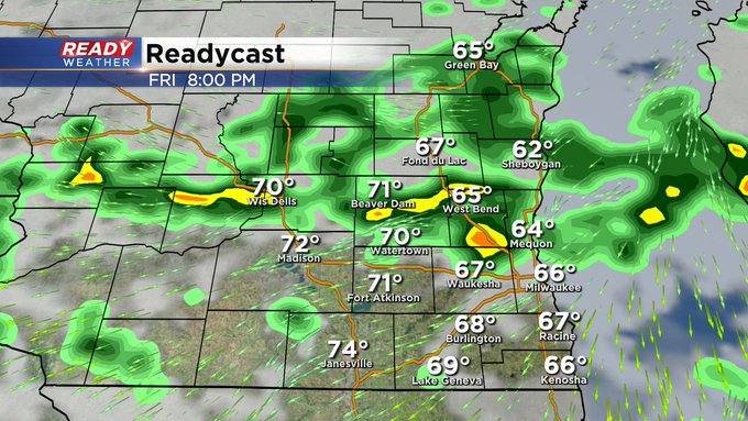
Updated: Friday, June 21st 6:10pm:
We have not had any warnings since just before 5pm this evening, which is a great sign. Storms continue, but are slowly wobbling north of the I-94 corridor. I'm hopeful that should leave Milwaukee dry for outdoor events this evening. At least until well after midnight. In the meantime we have other weather things going on down at the Summerfest grounds. Check it out:

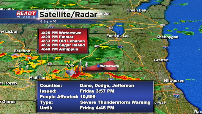
Updated: Friday, June 21st 4:15pm:
Storms are pulsing up to severe limits at this time. Here's the latest on the alerts:

Updated: Friday, June 21st 1:45pm:
Scattered thunderstorms are beginning to pop near the front in SW WI. These storms are already producing very heavy rainfall and will continue to strengthen as they move to the east throughout the afternoon.

Of note, there is a lake breeze which is keeping temps and dew points a bit lower lakeside. That being said, there remains a level 1, Marginal Risk, in place for all of SE WI this evening for damaging winds.
-------------------------------------------------------
Updated: Friday, June 21st 11:30am:
All eyes are on the stationary front to our south that has been slowly, but surely, lifting northward this morning. As of 11am, this front has moved into far SW WI and is sitting along the IL border. This front has been moving northward a bit slower than expected, so it may only reach the I-94 corridor at best.

Where this warm front ends up will be the focus for training thunderstorms between 3-10pm. Storms may be strong to severe at times with damaging wind being the main concern along with the flash flooding potential.

The Flood Watch may be expanded southward early this afternoon if the slow northward moving trends continue regarding this front.
----------------------------------------------------------------------------
Updated: 9:32 a.m. June 21, 2024
A few showers have popped up Friday morning but no thunderstorms yet. That thunderstorm risk doesn't start increasing until after 3 p.m. Friday afternoon.
Here's a look at the radar image that will update with time:

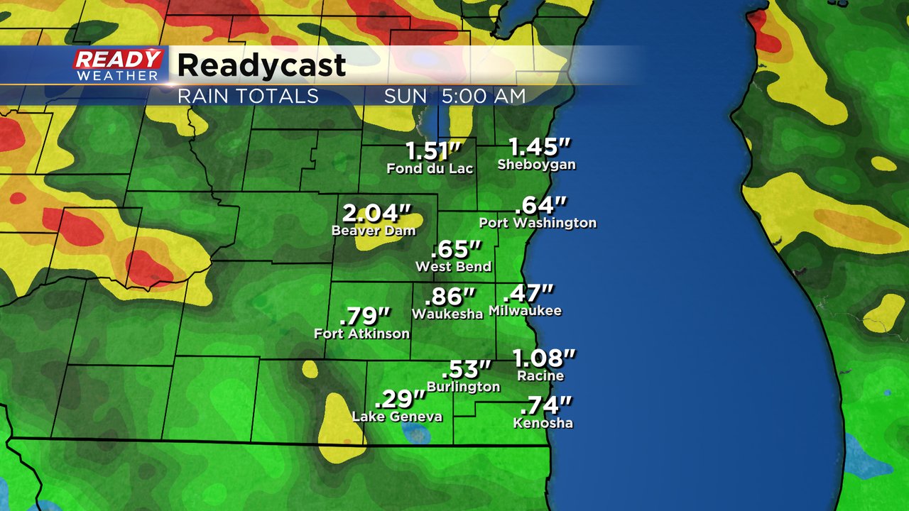
With the threat for heavy rain both Friday and Saturday. A flood watch has been issued for a number of counties in Wisconsin including Fond du Lac, Dodge, Washington, Jefferson and Waukesha Counties locally. Heavy storms and storms going over the same region multiple times could inflate rain totals above 2" in these locations.

The rest of the severe risk and storm chances outlined below are on track.
------
Posted: 5:51 a.m. June 21, 2024
Our rain chance will ramp up as we head into the beginning of the weekend. After a mostly dry start to the day Friday we see showers and storms return Friday afternoon and evening. Best chances Friday are after 3 PM.

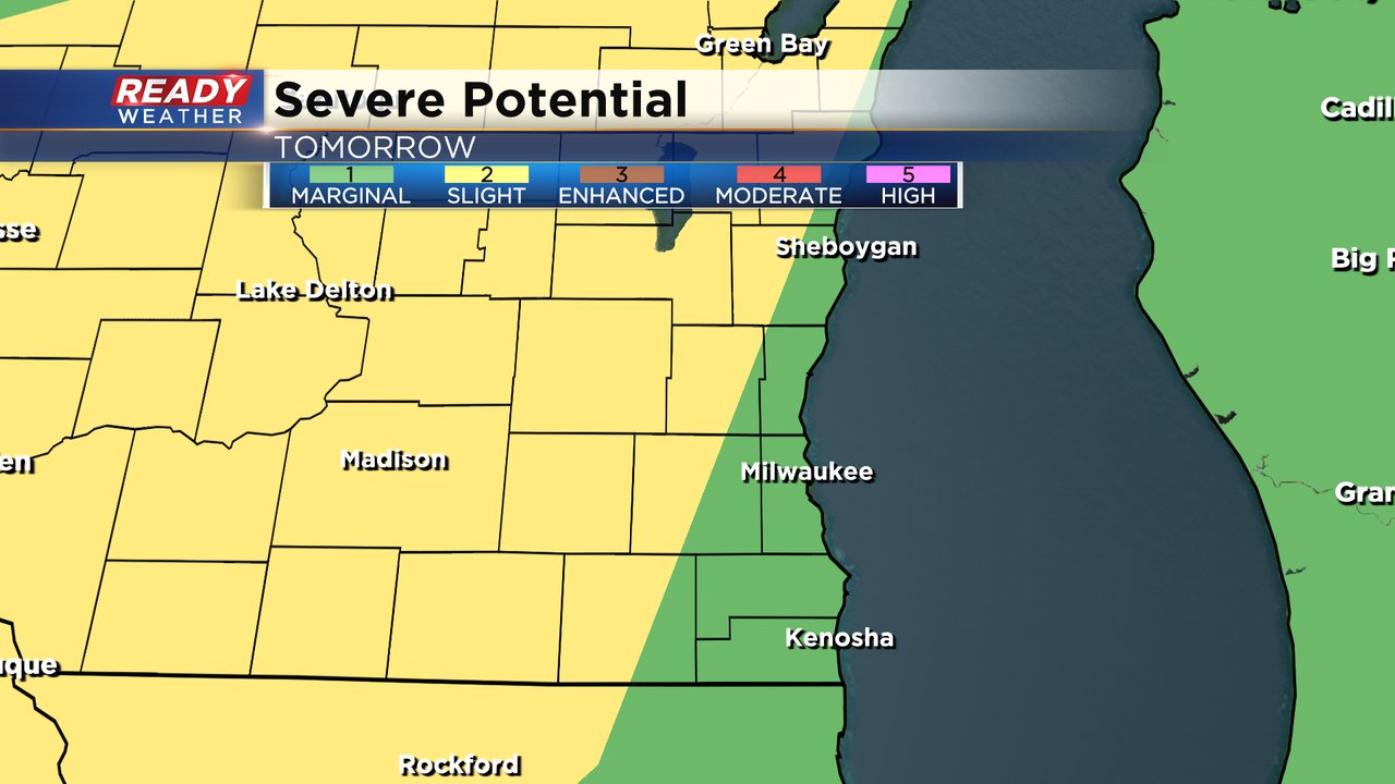
Some of the storms that form Friday afternoon and evening could be on the stronger side. All of southeast Wisconsin is under a Level 1 Marginal Risk for severe weather with the western fringes of Fond du Lac, Dodge and Jefferson Counties and areas west of there under a Level 2 Slight Risk.

The better storm chance arrives on Saturday with scattered storms likely throughout the day from the morning through midday and into the afternoon and evening. The best chance for strong to severe storms might be along the cold front with a line of storms Saturday evening.

Once again, strong to severe storms are possible with a better chance for seeing severe storms Saturday than Friday. Inland and western counties are under a Level 2 Slight Risk with a Level 1 Marginal Risk near the lakefront.
For both Friday and Saturday the main threats will be wind and flooding. A lot of rain is possible which could lead to flash flooding, ponding on roadways and minor street flooding. Some hail or an isolated tornado both days is also possible.

Rain totals from Friday into Saturday range from 0.50-1.50" for most of southeast Wisconsin but some locations could definitely get 2-3" of rain with storms. Because of the expected heavy rain, Fond du Lac, Dodge, Washington, Jefferson and Waukesha Counties have been added to a Flood Watch from Friday afternoon through Saturday night.
Download the CBS 58 Ready Weather app to track the storms with the interactive radar and plan out your weekend with the hour-by-hour forecast.