Overnight Update: Snow will continue overnight with slick roads
Updated: 10:00 p.m. Dec. 19, 2024
The overall intensity of the snow will continue to weaken overnight compared to this evening; however, an additional inch or so remains possible overnight. Roads will remain snow covered and slick.
Most of the snow will wrap-up around daybreak. Even though many inland areas will be out of the snow, the morning commute will be slick.
There is a possible lake effect band that could drop another inch near the lakefront Friday morning. That band is expected to move out by late morning. Winds for Friday will gust between 20 to 30 mph out of the north.
______________________________________________________________________________________________________________
Updated: 8:00 p.m. Dec. 19, 2024
Roads are a mess tonight, especially side roads and ramps to the highways. Use caution if you have to head out. Temperatures remain in the upper 20s and lower 30s, so snow will continue to stick to the pavement.
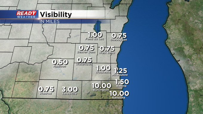
While the wind isn't strong tonight, higher snow rates are causing reduced visibility across the area.
Snow is forecast to continue overnight before the Friday morning commute. An additional 1" to 2" is possible across the area.
______________________________________________________________________________________________________________
Updated: 6:00 p.m. Dec. 19, 2024
Here are some of the latest reports.
Road conditions are a mess this evening as the snow continues to fall. The snow will continue overnight with another 2" to 4" possible. Overnight temperatures will hold in the upper 20s and lower 30s keeping roads snow covered.
Heavier snow bands will lower visibility, but the winds won't be strong until Friday morning. A lake effect band will impact the lakefront during the morning, but most areas to the west will be done. That band will only drop an additional inch.
____________________________________________________________________________________________________________
Updated:1:50 p.m. Dec. 19, 2024
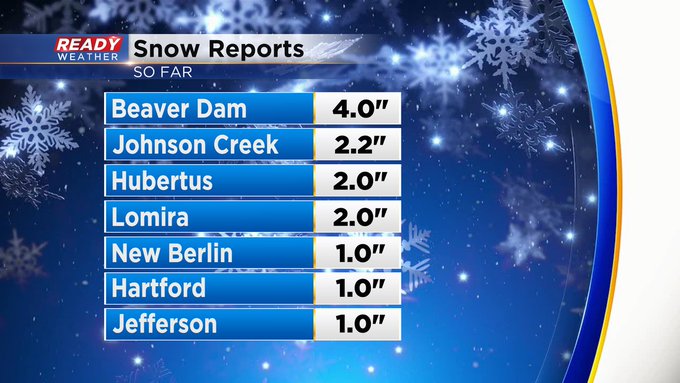
A few snow totals are now coming into the office. Have a look:
Snow has let up a bit around the metro for the moment, but still snowing steadily just north of the city. And we anticipate snow showers to continue to fill in as the later afternoon wears on.Updated:11:07 a.m. Dec. 19, 2024
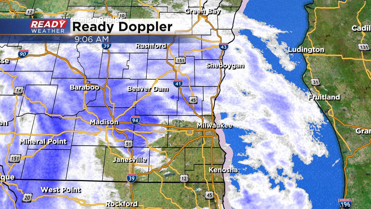
Snow is now widespread and steadily falling across the area. Here's the latest radar image:
So far we've gotten one report of 2.5" in Marquette county, which is two counties west of Fond du Lac county, outside the viewing area. But it gives us a good idea of the snowfall rate and trajectory of snow accruing here locally. We may start to snow rates in heavier pockets of about a half inch per hour. Visibility at times will be low as well. Here's how that looks now: Other than an earlier arrival time of the snow falling in the metro, the rest of the storm forecast is on track. Updates continue here through the day and evening, stick with us - we'll keep you ready!Updated: 9:07 a.m. Dec. 19, 2024
The first snowflakes and flurries of our next snow chance are starting to fall across southeast Wisconsin. Most of this snow is pretty light but could drop a quick dusting or an inch or two in some areas through the afternoon.
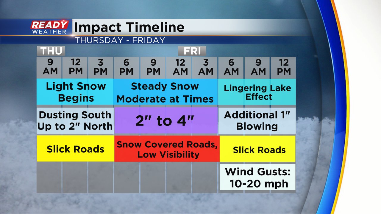
The most impactful time period for this snow will be from 5 PM to 5 AM where most of the accumulating snow is expected and the roads will become snow covered. Some lingering snow, mainly lakeside, is possible Friday morning with an additional inch. We may also see some blowing snow with winds becoming more breezy Friday.
The rate of the snow and the impact on the roads with snow covered travel will be the biggest threat. Thankfully, wind and cold air will not be a big issue with this storm.
The rest of the forecast outline below remains on track with 2-4" for our central and southern counties and 4-6" in northern counties. Lakeside portions of Sheboygan and northern Ozaukee Counties have the best chance to see around 6".
------
Posted: 5:11 a.m. Dec. 19, 2024
As expected, Thursday morning is starting out dry. Most of the morning commute will be just fine with some snow showers not starting to fall until the mid-morning hours of Thursday through the afternoon. Some areas could get a dusting or an inch or two of snow during this time, but the steady and moderate snow really doesn't start until Thursday evening through early Friday.
Some lingering morning snow on Friday, potentially through noon is also expected, especially lakeside. Some lake effect snow may add another inch of snow Friday morning. We dry out Friday afternoon with some sunshine possibly arriving before sunset.
There have been a few adjustments to the Winter Weather Advisory that was first issued Wednesday. Racine and Kenosha have now been added to the advisory. Walworth County is the only county not currently under any advisory. The start and end time to the advisory depends on what county you live in but starts between 9 AM - 12 PM on Thursday and ends Friday between 6 AM and Noon.
No big changes to the snow map from what we first showed you Wednesday. Most of southeast Wisconsin will get 2-5" of snow with the Waukesha/Milwaukee Metro area getting 2-4". A few southern counties might not quite get to 2" but should be pretty close over 1.5". Northern counties including all of Fond du Lac and Sheboygan Counties and northern parts of Dodge, Washington and Ozaukee Counties could get 4-6".
Download the CBS 58 Ready Weather app to track the snow with the interactive radar.


