Evening Update: Winter Storm Warning issued ahead of Thursday's heavy snow


Updated: Wednesday, February 15th: 6:00pm:
A Winter Storm Warning has been issued for most of southeast Wisconsin for Thursday with Winter Weather Advisories farther north from 9am - 9pm.
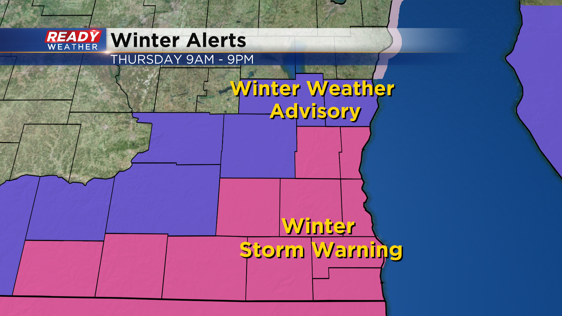
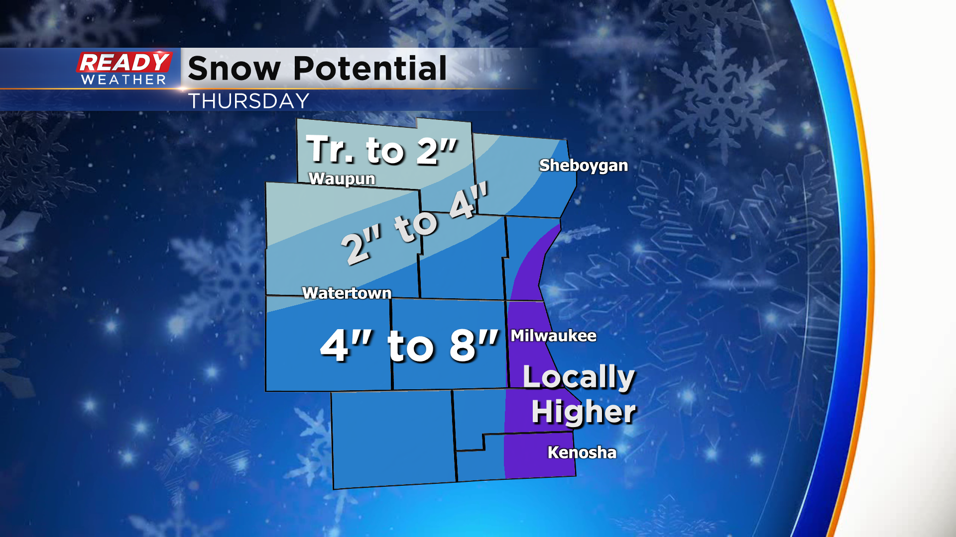
Between 4 to 8 inches of accumulation is expected within the Winter Storm Warning. Locally higher totals over 8" can't be ruled out lakeside as we will have a few hours of lake enhancement during the afternoon. With this system tracking to our south, there will likely be a sharp cutoff in snow totals across Sheboygan, Dodge, and Fond du Lac counties.
Light snow begins between 6-8am on Thursday and will pick up in intensity midday through early evening. Snowfall rates could be as heavy as 0.5" to 1.5" per hour during the afternoon, especially with the lake enhancement. This will create low visibility and difficult travel conditions as plows may have a difficult time keeping up with the snow for a few hours in the afternoon. Plan on a rough PM commute on Thursday.
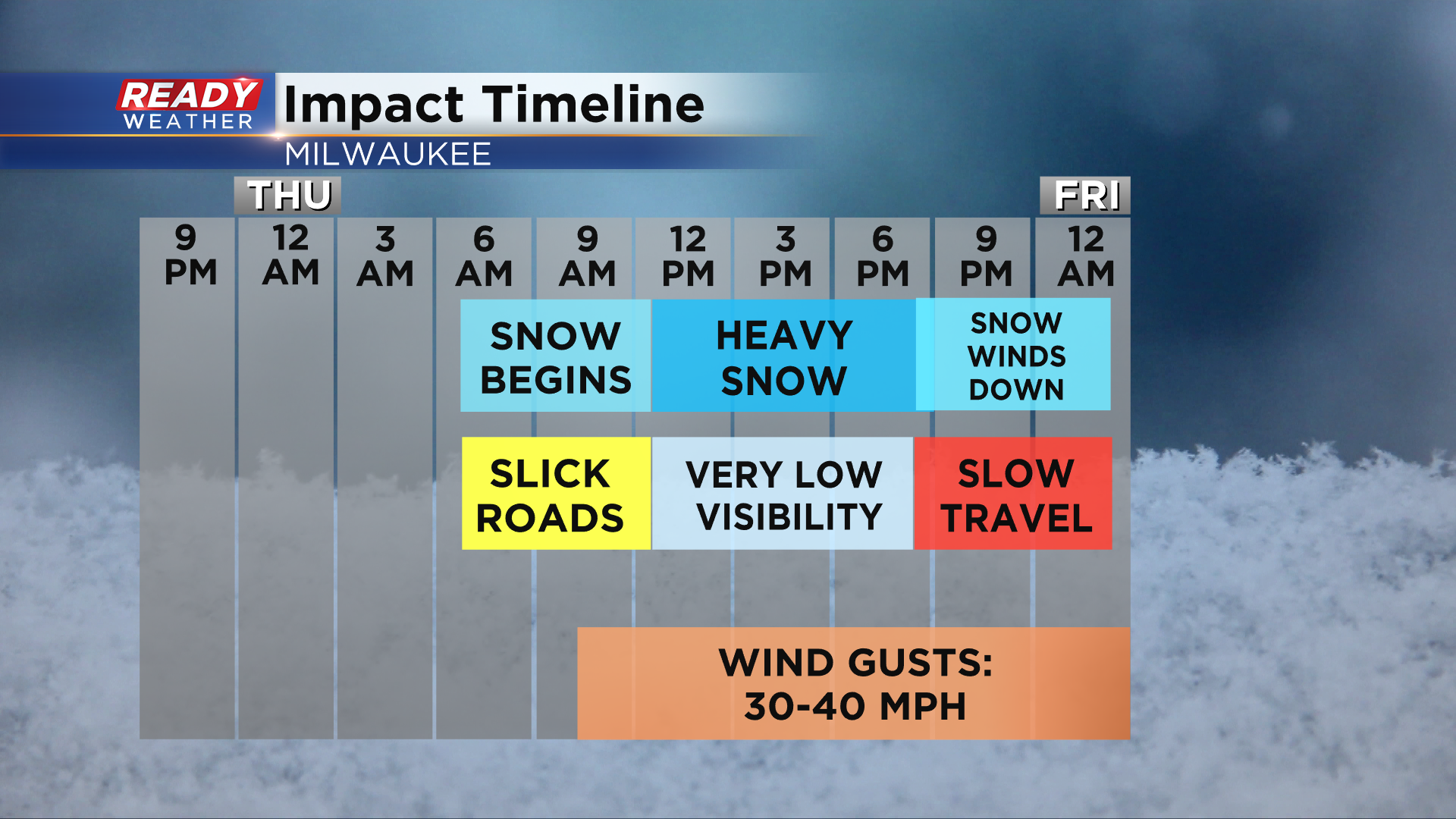
We will also be dealing with 30-40 mph wind gusts most of the day, which could cause blowing and drifting. Snow will become lighter in the evening and taper off overnight. Download the CBS 58 Ready Weather App to get video updates sent to your phone over the next 24 hours.
-----------------------------------------------------------
A winter storm watch has been issued for our next winter storm. The watch includes almost all of southeast Wisconsin but Fond du Lac County has been left out as a sharp cutoff of snow is expected in our northwest counties. No snow is expected on Wednesday with the watch in place on Thursday. This watch will likely be upgraded to a winter weather advisory or a winter storm warning Wednesday afternoon or Wednesday night.

The early morning commute on Thursday looks dry with snow rolling in during the morning commute although roads should still be in fairly good shape. The lunch time and evening commute looks to more heavily impacted with steady snow, coming down heavy at times, is expected from mid-morning through late evening.

There is still some uncertainty among the weather models in the exact track of the storm and a shift of only 25 miles could mean someone getting 0" of snow or 4" of snow. As of Wednesday morning, most of southeast Wisconsin looks to see a swatch of 4-8" of snow with a sharp cutoff to the northwest where 1-4" is expected. Expect changes to this map with 24 hours to go until the snow falls.

Overall this will be a wetter snow but not as slushy as the last event. Temperatures will be a little colder with afternoon highs hovering around freezing which will allow roads to become snow covered. Bands of heavy snow and some lake enhancement will be possible. Visibility will also be an issue as the wind gusts over 30 mph Thursday causing blowing and drifting snow. No mix is expected at this time.

Download the CBS 58 Ready Weather app to track all the snow.