We have effectively zapped out the humidity in today's forecast. A comfortable day in unfolding with a light lake breeze and plenty of sun. Highs fare in the low 70s. Thursday also means the weekly drought monitor is in and we have also wiped out any drought or even dry conditions across the state, even conditions nationally look good overall.
 Image
Image
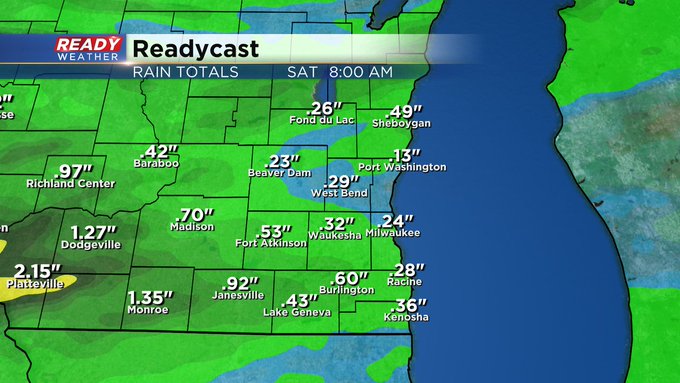
And additional wet weather chances move back in the next two days. An approaching area of low pressure and other pieces of instability will work this way for Friday. While temps will inch up, clouds will be more prevalent and eventually showers arrive. We may find a few late morning light showers, but the evening is now looking to find better chances for rain. Eventually as we head into the night factors come together that could trigger stronger downpours and some storms. That will last into Saturday morning. Here's a look at totals across southeast Wisconsin.
 Image
Image
About a quarter to half inch looks reasonable for our part of the state with higher totals just to our west. The last bit of stormy weather will be along a cold front that sweeps through the state early Saturday. Even behind the front the weather will be hot and muggy by Saturday afternoon and dry for Summerfest. In time the cool air works in Sunday with highs returning to below normal levels around seventy degrees.


