Late Evening Update: Snow will come to an end after midnight


Updated: 11:00 p.m. Jan. 9, 2024
The back edge of the snow is coming through right now. This snow band shouldn't cause too many issues; however, some roads will become snow covered.
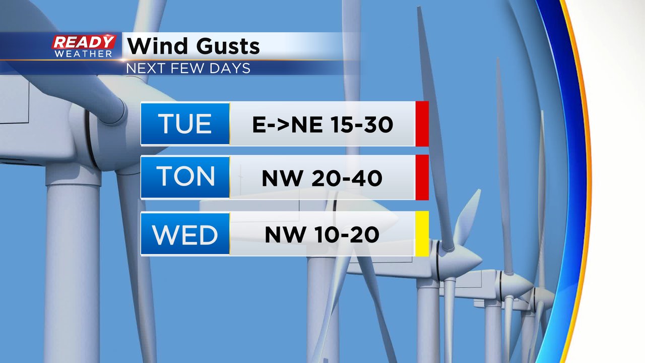
Another inch or so of snow is possible as it moves through. In addition to the snow, strong winds gusting to 30 mph will reduce visibility.
Light snow is forecast to end after midnight, but slick roads will remain as temperatures fall into the middle to upper 20s to around 30.
Another round of snow is coming for Wednesday evening into the overnight. A few inches is possible.
______________________________________________________________________________________________________________

Updated: 7:00 p.m. Jan. 9, 2024
The back edge of the snow is forecast to rotate through the area by midnight. While some snow is filling back in closer to the lake, the main band remains across our northwestern counties.
Another inch or so of snow is possible as it moves through. In addition to the snow, strong winds gusting to 40 mph will reduce visibility.
Light snow is forecast to end after midnight, but slick roads will remain as temperatures fall into the middle to upper 20s to around 30.
______________________________________________________________________________________________________________

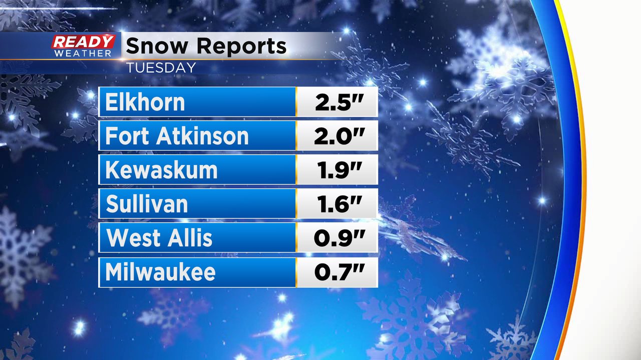
Updated: 5:00 p.m. Jan. 9, 2024
Here are some of the updated snowfall totals from today. We will continue to add to them this evening.

The last of the moderate snow will move through this evening. In addition to the snow, we are expecting strong winds that could gust to 40 mph. Winds will lower visibility. Another few inches of snow is possible before it wraps up after midnight.
Slick roads will still be an issue into Wednesday morning.
______________________________________________________________________________________________________________

Updated: 3:30 p.m. Jan. 9, 2024
The main part of the storm will be moving across our area from now until midnight. Heavy wet snow will continue to create snow covered roads all across southeastern Wisconsin. The lakefront has taken time to change over today, but we do expect snow to impact those areas throughout the evening.
Visibility will be reduced with heavy snow and strong gusty winds up to 40 mph. The snow will weaken after 10 pm and linger until 1 or 2 am.
While the main snow will end, slick roads will remain an issue into the Wednesday morning commute.
______________________________________________________________________________________________________________
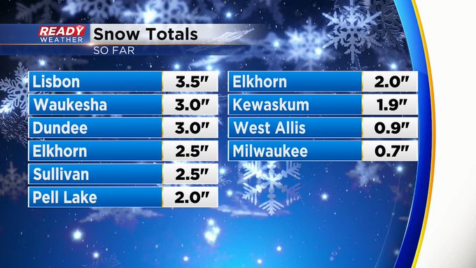
Updated: 12:55 p.m. Jan. 9, 2024
Snow totals so far are trickling in. Here's the latest:
Updated: 9:07 a.m. Jan. 9, 2024
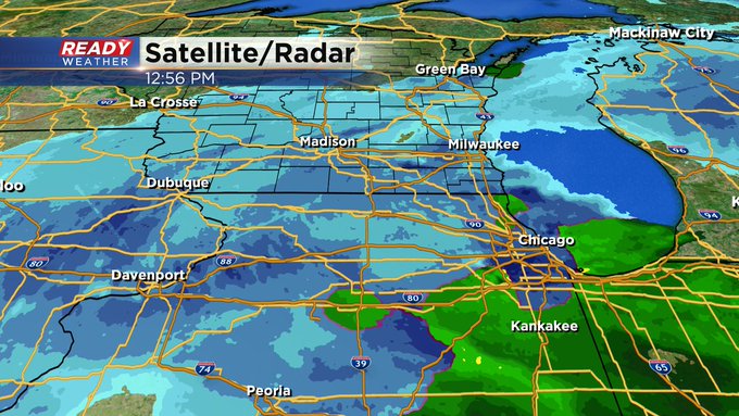
We are still seeing some rain mixing in lakeside with some lighter precipitation moving through. Steadier snow rolls back in towards midday with heavy snow still on track during the afternoon and evening.
Here's a radar image that will update with time:

Some of the first snow reports are coming in. As of 9 AM we've seen 1-3" in our inland and western counties. Lakeside areas saw most of their accumulation during the overnight hours before it switched to a rain, rain/snow mix. Storm total snow is still on track with most of southeast Wisconsin getting over 4" or 5" but some lakeside areas may see just a touch less with the rain/snow mix.
All of this snow is heavy and wet and will easily stick to power lines and tree branches. That wet snow combined with the strong wind could cause some power outages across parts of southeast Wisconsin. Wind gusts during the day Tuesday peak around 30 mph with strongest wind gusts Tuesday night to 40 mph then breezy on Wednesday and Thursday.
Stay on top of the storm with the CBS 58 Ready Weather blog!
------
Updated: 7:05 a.m. Jan. 9, 2024
This storm is still getting started. The steady snow has not arrived yet, but that will change as we go into the morning. Lakeside areas are currently seeing a rain/snow mix with some areas not seeing any snow accumulation at all. Inland counties are a different story with accumulating snowfall across most of Waukesha and Washington County and areas west of there.
We are also seeing some lulls in the action across southeast Wisconsin through Madison but an area of steady snow is quickly approaching.

Watch the wind gusts as well throughout the day with gusts to 30 mph possible during the day but ramping up to 40 mph Tuesday night. You can track wind gusts that will update with time here:

Download the CBS 58 Ready Weather app to track the hour-by-hour forecast and see when the worst part of the storm hits your house.
------
Posted: 4:41 a.m. Jan. 9, 2024
The first major winter storm of the 2023-24 winter season is here. All of southeast Wisconsin is currently under a Winter Weather Advisory but that switches to a Winter Storm Warning at 6 AM Wednesday for our entire viewing area. The warning goes until 3 AM on Wednesday.

Snow is already coming down at a pretty good rate Tuesday morning but we may see some brief breaks or lulls in the action during the early morning hours. By late morning the snowfall rates will pick up and the heaviest snow for southeast Wisconsin is expected during the afternoon and evening with 1" to 2" of accumulating snow per hour. By midnight most of the accumulating snow wraps up with flurries lingering into Wednesday morning.

There are no major changes to our snow forecast for Tuesday. There's been a slight jog to the southeast with the track of the storm which may reduce some of the higher totals in our western and northwestern counties but at least 4-5" still looks good there. Highest totals should be around 9-10". There are still some questions lakeside with a stiff east wind and warmer air temps slightly reducing totals there. But when the wind shifts to the north this evening the snow will quickly accumulate there. Overall 3-5" is expected within a few miles of the lakefront but even the west side of the City of Milwaukee could get over 5".

The heavy snow will be the biggest threat with this storm, but the wind threat is increasing. Wind gusts during the day Tuesday could reach 30 mph with gusts at night to 40 mph. With the heavy wet snow sticking to powerlines and trees this could cause some tree damage and power outages. The Tuesday morning commute is still not expected to be too bad but the evening commute will be awful.

Download the CBS 58 Ready Weather app to track the snow all day!