Heat advisory with our next t-storm chance


After it felt like relief came with cooler temps these past few days, a wind yesterday out of the southwest has pushed the heat right back in!
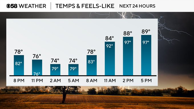
The heat and humidity aren't going anywhere anytime soon, as tomorrow is expected to be even hotter than today, with almost all of us feeling like the triple digits by the afternoon. Because of this, a heat advisory has been issued and will remain in effect until tomorrow late evening.
As hot and humid conditions continue on, this will help fuel our next round of rain and potentially some stronger storms. Overnight, heavy rain and thunderstorms will build in from the northwest bringing in heavy downpours, and the chance to see hail and very gusty winds.
Rain chances will hold up until the lunch hour before things turn quieter for the afternoon. We then have another chance to see storms late tomorrow night into early Tuesday. Another round of t-storms follows that into Tuesday afternoon, and then again into Wednesday.
Behind this system late Wednesday, a cold front will drop in, not only cooling us off, but helping relieve some humidity. As this system clears out, we turn quieter as well, with more sunshine to end the work week.