5pm Update: Snow showers will wind down this evening, but winds remain strong


5pm update:
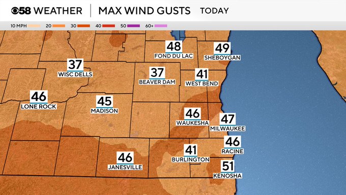
While not much snow has accumulated, it surely was blowing around today with a stark change in weather conditions from yesterday. Look at these peak winds.
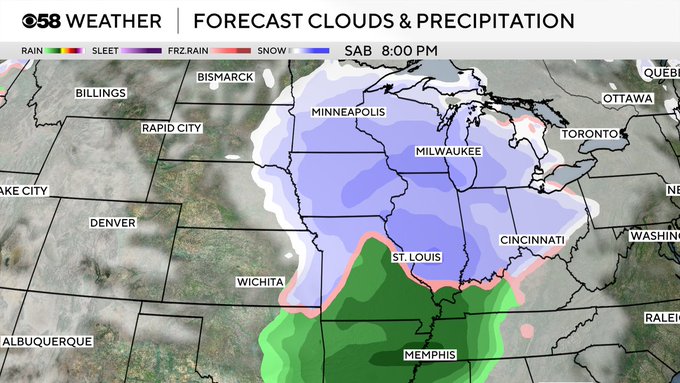
We are also monitoring weekend snow, stay with us for updates on that in the days ahead.
3pm Update:
Both advisories still are active, and light to moderate snow is still continuing to fall. Quieter sky conditions are expected to slowly make their way in after 5-6pm, but windy conditions will hold keeping feels like temps near the single digits by tomorrow morning.
Noon Update:
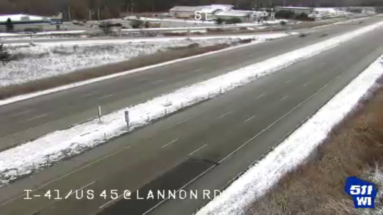
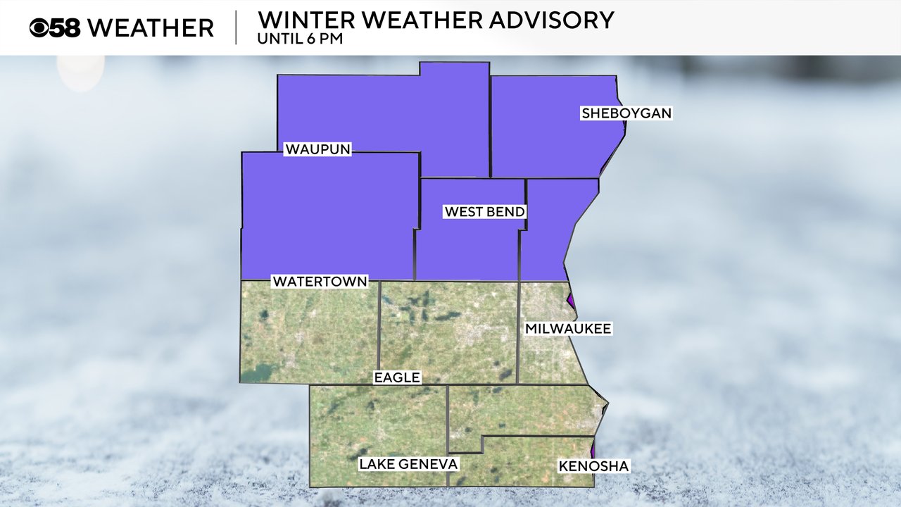
Our Winter Weather Advisory still remains in effect until 6pm this evening, and that is where snow is currently holding heading into this afternoon. While some light accumulation is still possible, road conditions have greatly improved, and most roads are just wet and no longer icy. Slick spots, however, continue to hold up north.
The main story continues to be the gusty winds following this snowy system with gusts at the lunch hour ranging from 40-50mph. This is continuing to blow snow around and reduce visibility. Our Wind Advisory is still in place until 6pm this evening despite the fact that gusty winds will hold for likely the next week.
Updated: 10:01 a.m. Nov. 26, 2-25
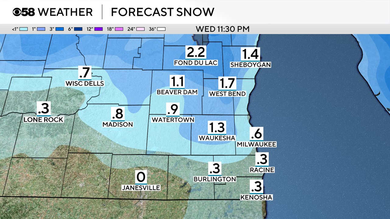
Scattered snow showers are continuing this Wednesday morning. Some bursts of moderate snow have been falling but most of the snow remains fairly light and scattered. These snow showers are expected to continue through the early evening hours. Most areas are still on track to see 1-2" of snow with isolated locations in northern counties seeing as much as 3".
Here is a radar image that will update with time:

So far roadways, especially main freeways, are in good shape and are just wet. Many roads were pre-treated with brine Tuesday night and while snow is accumulating on the shoulders and grassy areas the roads themselves are staying dry. Road temperatures are also pretty mild after a few days in the 50s.
The wind is a bigger issue with gusts frequently over 40 mph so far Wednesday. Gusts could get as high as 50 mph on Wednesday and the Wind Advisory remains in effect until 6 PM.
Here is a map of wind gusts that will update with time:

The rest of the forecast information posted below remains on track, including the bitter cold on the way.
------
Posted: 5:21 a.m. Nov. 26, 2025
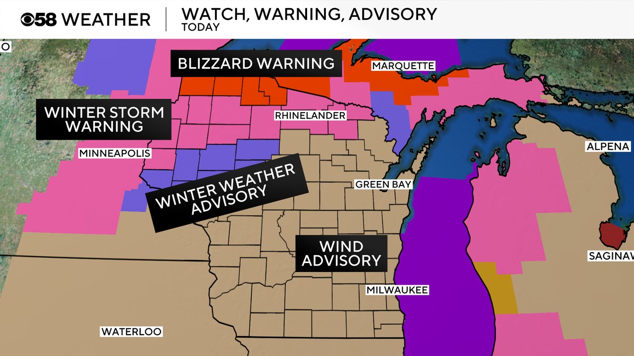
The busiest travel day of the year is here and Wisconsin weather is not cooperating. We have multiple advisories and warnings across the state Wednesday. A winter weather advisory is in effect until 6 PM Wednesday for our northern half of counties including Fond du Lac, Sheboygan, Dodge, Washington and Ozaukee Counties. These are the areas most likely to get 1-3" of snow with strong wind causing blowing and drifting snow.
In addition, a wind advisory is in place for all of southeast Wisconsin, and most of the state, until 6 PM. Wind gusts could reach 50 mph during the day Wednesday.

If your Thanksgiving travels take you into northern Wisconsin or to the northwest towards Minneapolis the weather will get worse. More snow is expected, and especially in the open farmland near blizzard conditions are possible. A Winter Storm Warning is in effect towards Minnesota and a Blizzard Warning is in effect for far northern Wisconsin.
The snow showers are already falling as of early Wednesday morning and likely stay with us most of the day. The snow wraps up by 7 PM in most areas Wednesday. Some of the snow could come down in heavier bursts at times. Given the scattered nature of the snow, some dry time is also possible and roads should stay in decent shape besides the blowing in open areas.
Here is a radar image that will update with time:

Snow totals haven't changed too much from what we showed you Tuesday with the best chance for over 1" north of I-94 where up to 3" is possible. Right along the I-94 corridor from Madison to Milwaukee could get around an inch with just less than that number in our southern counties.
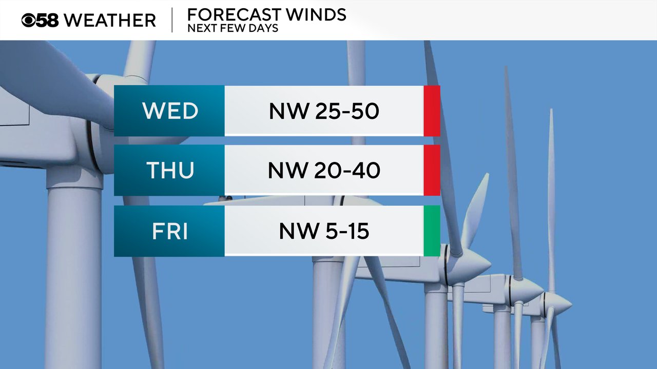
Wind gusts will whip all day long Wednesday as they turn to the northwest and gust from 25-50 mph. Even though no wind advisory is in place for Thanksgiving Day it's still going to be windy with gusts to 40 mph. Thankfully by Black Friday the wind becomes much lighter from 5-15 mph.
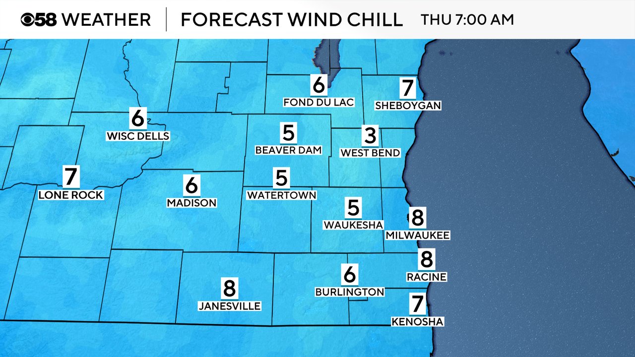
All of that wind will cause some very cold wind chills as temperatures drop. Feels like temps will drop into the teens by Wednesday afternoon. If you are doing a "Turkey Trot" Thanksgiving morning it is going to be COLD with wind chills in the single digits in most areas. Thursday afternoon the wind chills stay in the teens. Friday morning will stay have very cold wind chills for early shoppers but as the wind lightens up during the day Friday the wind chills will warm into the low 20s.
Download the CBS 58 Weather app to track the snow with the interactive radar.