Mid afternoon update: Patchy rain and snow to continue through the afternoon


Updated: Wednesday, April 3rd 3:15pm:
Off and on light rain showers will continue into the early evening with no issues expected on the roads for the PM commute. We'll get a bit of a lull in the precipitation late this evening, but another batch of snow will pivot into SE WI early Thursday morning.

An inch or less of accumulation is expected with this early morning round, but it may create slick spots during the Thursday morning commute.
---------------------------------------------------------------------------------
Updated: Wednesday, April 3rd 1:00 pm:
Patchy rain and snow showers continue to fall across southeast Wisconsin early this afternoon, but the stronger April sun angle is helping temps warm above freezing area-wide.

Additional accumulation through the afternoon will be minor thanks to the warmer temps.
---------------------------------------------------
Updated: Wednesday, April 3rd 11:00 am:
The steadiest and more moderate snow is pushing to the south late this morning.

Lighter, more patchy snow/slush is expected through the afternoon. Since the steady snow is coming to an end, the Winter Weather Advisories have been cancelled early.

Temps will warm slightly above freezing this afternoon which will help with melting and compacting. However, wind gusts of 25-35 mph will continue through the afternoon.

---------------------------
Updated: 9:00 a.m. Apr. 3, 2024
After some pockets of dry time during the early morning hours of Wednesday the precipitation has started to fill in and the mix has transitioned to mostly snow. Steady snow (and some mix) is expected through the rest of Wednesday morning with more snow and mix showers expected Wednesday afternoon and evening then some light precipitation on Thursday.
Here's a look at the radar that will update with time:

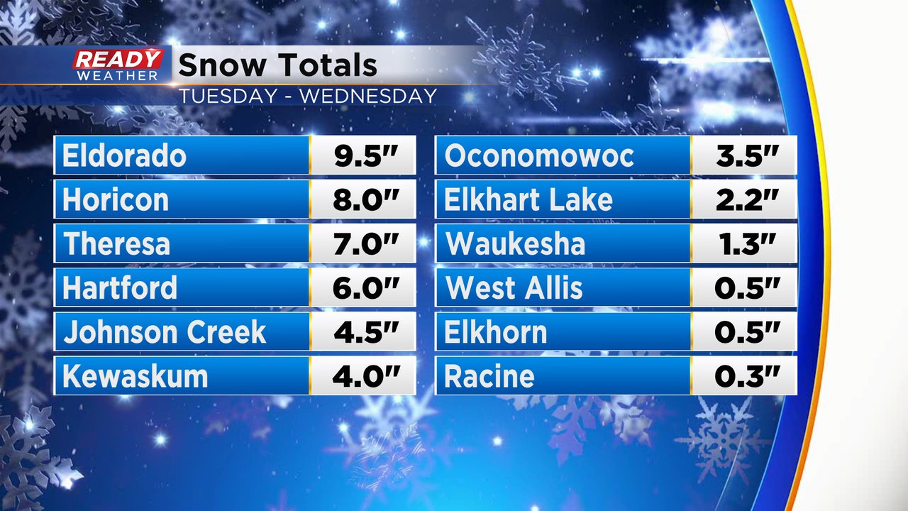
Snow totals so far Tuesday and Wednesday have been on track with the forecast with highest totals in Fond du Lac, Dodge and parts of Washington County where 5-10" of snow has fallen, inland areas picked up 1-4" with only a few tenths in most lakeside communities.
In addition to the snow, the wind is also strong in some localized areas. Fond du Lac and Sheboygan Counties have seen wind gusts Wednesday morning close to 40 mph. Strong winds are possible throughout the next few days.
Here's a look at wind gusts that will update with time:

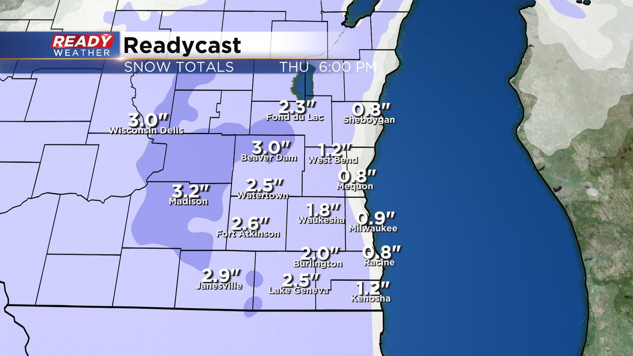
There have been no changes to the advisory outlined below and most areas away from the lakefront could get another 1-3" of snowfall Wednesday and Thursday.
------
Posted: 5:19 a.m. Apr. 3, 2024
What a wet and snowy last 24 hours it has been. We almost set a record for daily rainfall in Milwaukee with 1.38" falling from midnight to midnight Tuesday. The record is just over 2". While Milwaukee and some southern and lakeside communities stayed all rain, we did see a switch to snow in western and northern counties during the afternoon and it came down fast. Snow totals in these areas have already reached 3-6".
Any winter storm warnings have been canceled and replaced with a winter weather advisory. That advisory is still in effect for Fond du Lac, Sheboygan. Dodge, Washington, Jefferson, Waukesha and Walworth Counties until 1 PM Wednesday afternoon.

After some breaks in the snow and mix Tuesday night into early Wednesday we are now starting to see the snow fill back in west and north of the Metro and mainly rain/snow mix in Milwaukee and southern areas. Some steady snow and mix will continue through the morning then the precipitation becomes a bit more showery this afternoon and evening.

We may get a lull in the snow and mix Wednesday night but some lingering light snow and mix lakeside will likely continue through most of Thursday before drying out on Friday and Saturday.
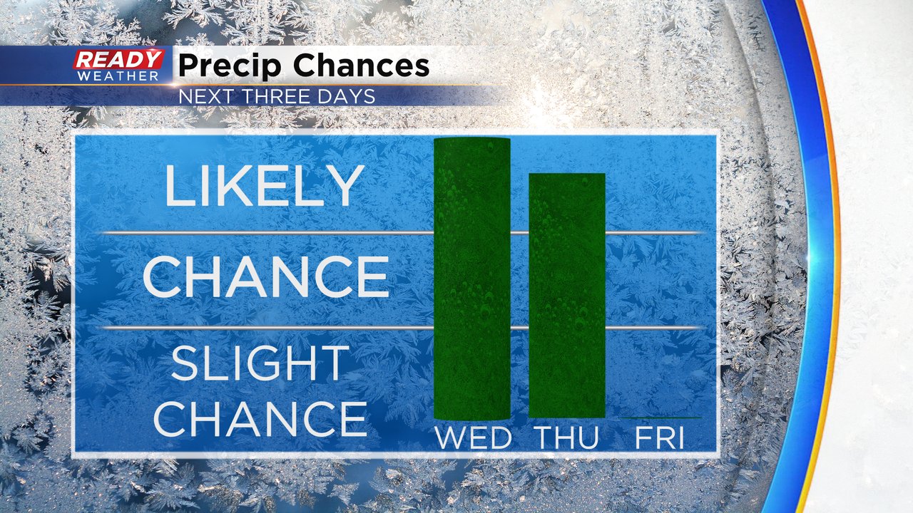
Additional snowfall for Wednesday and Thursday looks like maybe a dusting to an inch of snow on grassy surfaces lakeside but roads staying mostly wet. Inland counties have a better chance to see 1-3" of new snow.
Download the CBS 58 Ready Weather app to track the continued snow and mix with the interactive radar.